|
 Kenya Project

This year 4th
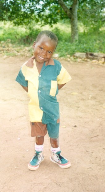
Class is sponsoring a child, Jumaa James Kithi, in Malindi, Kenya. They've also
been finding out a lot about his country.
|

Map of Africa
|

Jumaa James Kithi
|

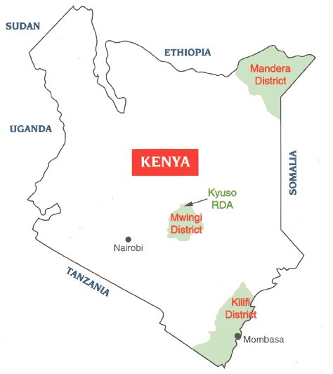
A map of Kenya
|
|
Kenya’s
Geography
Kenya is in East Africa. Tanzania, Uganda, Sudan,
Somalia, Ethiopia and the Indian Ocean bound it. Kenya has many extinct
volcanoes. The Nyika and Tana plains are home to the Lorian swamp. A
famous lake on the border of Kenya is Lake Victoria. Kenya’s only true
desert is the Chalbi desert. Kenya’s highlands are also called White
highlands. Two mountains are Mt. Niandarawa and Mt. Elgon.
30% of the land is Forested and 37% of the land is pasture.
The principal rivers are the Tana or Athi.
By Rosie Kings
|
|
NAIROBI.
Kenya’s capital is Nairobi. The city has a large tourist industry.
During the early 1990’s.Nairobi suffered from civil unrest. Nairobi
was founded in the late 1890’s as a British rail- road camp on the
Mombasa to Uganda railroad. In 1963 Nairobi was made capital of a new
independent Kenya. Nairobi is the fastest growing city in Africa.
Nairobi is in the centre of Kenya. Nairobi has a National Park, museum
and theatre. The Nairobi dam is on the river Gnong.
By Kate Power
|
|
Mombasa
Mombasa is the chief seaport of Kenya. Arab traders founded Mombasa
in the 8th century. Britain took rule of Mombasa in 1895.
It was made Capital of the coastal Protectorate in 1920 and in 1963
it was made part of independent Kenya.
Mombasa has often been a port of call for American naval vessels.
Population Estimate: 425,600
By Rosie Kings
|
|
KENYAS NATIONAL FLAG.
The three major colours in this flag are green, red, and black,
There is also white separating Black and green, the shield is also
red.
THE COLOURS
Black represents the people of Kenya.
Red represents the bloodshed in the fight for independence.
Green represents the fertility of the land.
White represents peace.
The shield of the warrior represents Kenya's pride and tradition.
By Maria Power
|
|
GEOGRAPHY OF KENYA
Kenya is located in East Africa. Tanzania, Sudan, Ethiopia, Somalia
and Uganda border Kenya. The country is divided into seven geographical
regions there names are the coastal strip, the Nyika and Tana plains,
the Kenya Highlands, the Rift Valley, the western plateau. Over 70% of
the country is very dry receiving just 20 inches of rain every year.
RIVERS, MOUNTAINS, TOWNS
Some mountains in Kenya are Mt. Kenya, Mt. Niandarawa, Mt. Elgon, and
the Aberdare Range. The principal rivers are the Tana and the Galana or
Athi. Mombasa is just beside the Indian Ocean. The six biggest towns in
Kenya are Ladwar, Kitale, Eldoret, Nakuru, Nyeri, and Kisumu.
BY:ANDREW EARLEY .
|
|
Tribes.
In the Luhya
tribe, men traditionally
prepare crops or sowing or organize weddings, while he women’s job is
harvesting. Shields are made of whicker, and are large enough to shelter
two grown men. The Luyha tribe makes pottery with beautiful designs, The
tribe grows maize, grain, cotton and tobacco. Women usually made
pottery, while men made basketwork.
The Luo tribe has many cattle and lots of land. The Luo’s clothing
is the most decorative in Kenya. The Luo eat mostly cooked fish. They
also have milk and milk products. Sometimes they eat meat. The Luo have
a one-stringed lyre called ‘ortu’, which plays haunting melodies.
By
Siobhan
|
|
Kenyan tribes- The Kalenjin
The Rift Valley province is the biggest province in Kenya. Three and
a quarter million people live here, half of which are Kalenjin. The
largest in the Kalenjin is the Kipsigis. The second biggest is the Nandi.
Music to accompany dancing derives from the reed flute to the five
stringed lyre, the strings of which are made from a cow gut and
stretched over a bowl covered with dik-dik or goat skin. Witchcraft is
despised and therefore is practised with the utmost secrecy. Today the
Kalenjin are disciplined farmers. A phenomenon not entirely understood
is that almost all the Kenyan great distance runners such as Keino and
Rono are Kalenjin.
Conor
Nolan
|
|
![]()