|
|

Chariotry and the road
systems in the Celtic World
Raimund Karl
Centre for Advanced Welsh and
Celtic Studies, Aberystwyth
 Chariot
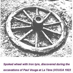
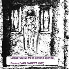
parts seem to exist in abundance from continental Europe
(e.g. VOUGA 1923, VAN ENDERT 1987) and Britain (e.g. RITCHIE
1995) in the La Tène period, backing up the
importance ascribed to chariots in the ancient historical
sources about the Celts - as Diodorus writes in DIO V, 29.1:
"In their journeyings and when they go into battle the Gauls
use chariots drawn by two horses, which carry the charioteer
and the warrior …" (OLDFATHER 1939, 173) Chariot
parts seem to exist in abundance from continental Europe
(e.g. VOUGA 1923, VAN ENDERT 1987) and Britain (e.g. RITCHIE
1995) in the La Tène period, backing up the
importance ascribed to chariots in the ancient historical
sources about the Celts - as Diodorus writes in DIO V, 29.1:
"In their journeyings and when they go into battle the Gauls
use chariots drawn by two horses, which carry the charioteer
and the warrior …" (OLDFATHER 1939, 173)
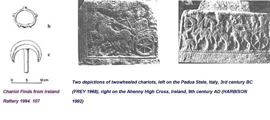
Also,
their existence in Ireland, even though having come under
doubt in the recent years (e.g. RAFTERY 1994), has been
recently demonstrated for at least the Early Medieval
period, and in extenso for the La Tène period as
well, the carpat of Irish literature having been
demonstrated to be a late variant of the type of vehicle
known as carpentum in the ancient historical sources
(KARL&STIFTER 2002). Of course, the few pieces that once
belonged to chariots, that have been found in Ireland
(RAFTERY 1994, 106f.) are hard to interpret and not
especially indicative for the presence of chariots, but in
combination with the much later early medieval literature,
where chariots appear in almost every kind of text, from
epic saga literature over saints lives to legal texts, their
appearance in decorative reliefs on stone monuments
(HARBISON 1992, 11) and bog roads (RAFTERY 1992, 54 ff.)
that fit well with the early medieval legal texts on roads,
clearly demonstrate the existence of chariots in Ireland in
the Iron Age.
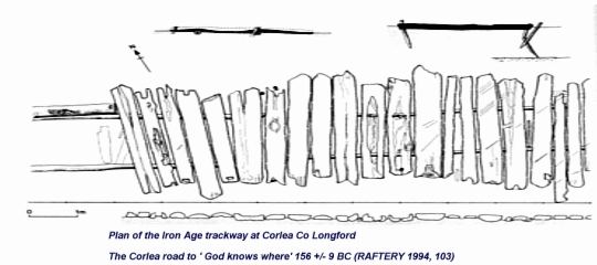
Especially
these roads, roads that seem to, at least in Ireland, lead
to "God knows where", as Raftery (1994, 101) has put it, are
of high interest for understanding not only wheeled
transport in Iron Age and Early Medieval Ireland, but also
travel, trade and communications networks in Iron Age
continental Europe.
Roads to nowhere,
everywhere
The
Irish Lawtexts tell us a lot about roads and road systems in
Early Medieval Ireland. As the road legislation in Early
Irish law stood in direct connection to the carpat (KELLY
1997, 538), and as carpat and roads that fit with these
legal norms can be documented much earlier (RAFTERY 1992, 54
ff.; RAFTERY 1994, 106 ff. und see illustration 5), it can
hardly be assumed that the legal connection between roads
and carpat developed only in Early Medieval Ireland, even
though the Irish road legislation shows, according to Kelly,
some parallels to the chapter 'De itineribus' "on
roads" in Isidor's Etymologies (KELLY 1997, 537). That
something like road legislation must have already existed in
ancient Gaul is evident from Caesar's De Bello Gallico,
where he tells us that the Aeduan Dumnorix had rented the
tolls within the Aeduan territory (DBG I, 18.3). As the term
"portoria", that Caesar uses in that specific situation, can
hardly have been limited to Harbour tolls, given the
geographical situation of the Aeduan territory, road- and
bridge-tolls will probably have made up the greater part of
the tolls rented by Dumnorix. However, as it wouldn't have
made any sense for the tribe to give away the tolls if there
hadn't been any obligation combined with this tolling of
routes, it is most likely that the care for the constant
upkeep of the roads was part of this deal. At least for high
traffic roads, we can be pretty sure that the upkeep of a
sufficent street width was part of this
arrangement.
 That
roads with a sufficent width did not only exist within the
territory of one specific civitas, but also between the
territories of several civitates, thus forming "overland
routes", is yet again evident from Caesar's account. He
writes: "Erant omnino itinera duo, quibus itineribus domo
exire possent. unum per Sequanos, angustum et difficile,
inter montem Iuram et flumen Rhodanum, vix qua singuli carri
ducerentur, mons autem altissimus impendebat, ut facile
perpauci prohibere possent; alterum per provinciam nostram,
multo facilius atque expeditius, propterea quod inter fines
Helvetiorum et Allobrogum, qui nuper pacati erant, Rhodanus
fluit isque nonnullis locis vado transitur. Extremum oppidum
Allobrogum est proximumque Helvetiorum finibus Geneva. ex eo
oppido pons ad Helvetios pertinent." (DBG I, 6.1-3)
"There were but two roads that they could choose for leaving
their homeland. The one led trough the territory of the
Sequani but was, as it ran between the Rhône and the
Jura, that narrow, that hardly a single wagon could be
driven on it; and even more than that, a high mountain range
commanded the road, so that a small number of people was
sufficent to close it. The other one led trough our province
and was much easier and comfortable to use, as between the
territories of the Helvetii and the Allobroges, who have
been conquered some time ago, runs the Rhône, which
can be forded at several places. The last city of the
Allobroges, immediately at the Helvetian border is Geneva.
From this city, a bridge leads into the Helvetian
territory." That
roads with a sufficent width did not only exist within the
territory of one specific civitas, but also between the
territories of several civitates, thus forming "overland
routes", is yet again evident from Caesar's account. He
writes: "Erant omnino itinera duo, quibus itineribus domo
exire possent. unum per Sequanos, angustum et difficile,
inter montem Iuram et flumen Rhodanum, vix qua singuli carri
ducerentur, mons autem altissimus impendebat, ut facile
perpauci prohibere possent; alterum per provinciam nostram,
multo facilius atque expeditius, propterea quod inter fines
Helvetiorum et Allobrogum, qui nuper pacati erant, Rhodanus
fluit isque nonnullis locis vado transitur. Extremum oppidum
Allobrogum est proximumque Helvetiorum finibus Geneva. ex eo
oppido pons ad Helvetios pertinent." (DBG I, 6.1-3)
"There were but two roads that they could choose for leaving
their homeland. The one led trough the territory of the
Sequani but was, as it ran between the Rhône and the
Jura, that narrow, that hardly a single wagon could be
driven on it; and even more than that, a high mountain range
commanded the road, so that a small number of people was
sufficent to close it. The other one led trough our province
and was much easier and comfortable to use, as between the
territories of the Helvetii and the Allobroges, who have
been conquered some time ago, runs the Rhône, which
can be forded at several places. The last city of the
Allobroges, immediately at the Helvetian border is Geneva.
From this city, a bridge leads into the Helvetian
territory."
Thus,
there was at least one road at each side of the Rhône,
which led out of the territory of the Helvetians, of which
the one was that narrow, that hardly a single wagon could
pass it, which tells us not only that the other was much
easier and comfortable to use, but also that it was at least
wide enough for a single wagon to use it most easily, and
this one even led across the Rhône via a bridge at
Geneva.
Considering
the geographical situation along the Helvetian borders, and
also considering that not everywhere in the Celtic world
such geomorphological limitations existed as in case of the
Helvetian territory, it can most safely be assumed that the
territories of the other Gaulish civitates were connected by
more and most probably better developed roads and road
networks that the Helvetians with their western
neighbours.
It
is equally evident that a well developed local road network
must have existed: „Collis erat leviter ab infimo
acclivis. hunc ex omnibus fere partibus palus difficilis
atque impedita cingebat non latior pedibus quinquaginta. hoc
se colle interruptis pontibus Galli fiducia loci
continebant…" (DBG VII, 19.1-2) „It was a gentle
hill, that was almost completely surrounded by swamps of no
more than 50 feet width. The Gauls broke down the bridges
across the swamps and, trusting in the advantages the
territory gave them, remained on the hill."
Obviously,
the Gauls even bridged swamps  ,
and this sufficently solid to have an army march over it,
just to gain access to a gentle, dry hill. Would these
bridges have been simple narrow footmen crossings, that
could have been defended eassily against single enemies
advancing on them, it is hardly imagineable that the Gauls
would have broken down the bridges crossing these swamps, as
such, it is most likely that these bridges actually were
wide enough to allow a wheeled vehicle to access the hill
via them. Now, if several traffic-proof bridges were built
to gain access to a hill that was most likely used for
agricultural purposes only, and if at the same time overland
roads existed that could be used by wheeled vehicles, then
we have to assume a well-developed road system with local
and long distance routes in Gaul at Caesar's
times. ,
and this sufficently solid to have an army march over it,
just to gain access to a gentle, dry hill. Would these
bridges have been simple narrow footmen crossings, that
could have been defended eassily against single enemies
advancing on them, it is hardly imagineable that the Gauls
would have broken down the bridges crossing these swamps, as
such, it is most likely that these bridges actually were
wide enough to allow a wheeled vehicle to access the hill
via them. Now, if several traffic-proof bridges were built
to gain access to a hill that was most likely used for
agricultural purposes only, and if at the same time overland
roads existed that could be used by wheeled vehicles, then
we have to assume a well-developed road system with local
and long distance routes in Gaul at Caesar's
times.
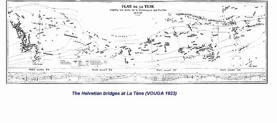
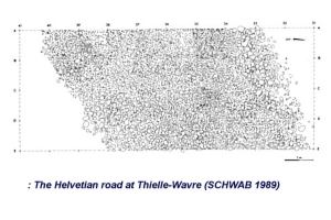
That
such a road system did actually exist, can be documented
even archaeologically within the territory of the
Helvetians. With the finds during the Jura water corrections
at La Tène, Cornaux-Les Sauges and at several other
places along the Thielle and Broye rivers in Switzerland
(SCHWAB 1989) a great number of bridges and even a
surface-metalled road from the La Tène period were
located in an area of several square kilometers.
|

|
In
Britain, the situation in regard to the road system is very
similar: "Et, cum equitatus noster liberius praedandi
vastandique causa se in agros effunderet, omnibus viis
semitisque notis essedarios ex silvis emittebat et magno cum
periculo nostrorum equitum cum his confligebat atque hoc
metu latius vagari prohibebat." (DBG V, 19.2) "As our
cavalry disbanded carelessly, to loot and to destroy the
countryside, Cassivellaunus sent his chariots against them
on all known ways and roads out of the forests, engaging our
soldiers in dangerous fights. From there on, they no longer
roamed the countryside out of fear, "
Even
with a vehicle with a spring suspension, as the carpentum
and most probably the Britsh essedum were, with which a
certain mobility off roads is possible, a serious attack on
cavalry using cattle driving ways or trampled paths is
hardly possible, at least not in an effectivity to strike
fear into Roman cavalry, even if this cavalry is operating
disbanded. Even narrow wagon trails seem to be insufficent
for such an attack, as is strongly restricts the mobility
and turnability of chariots, which would be necessary to
make them dangerous to cavalry, which is very mobile even on
relativy narrow paths. A rapid hit and run tactic, as seemed
to have been applied by Cassivellaunus here, is only
possible if the chariots can turn quickly to run. Even more,
it seems to be especially unlikely that an army, operating
with 4000 chariots, is able to, in the cover of a forest
(!), follow the Roman legions, which are marching on a main
road on open territory. If we do not want to assume that
Caesar invented this whole episode completely, it has to be
assumed that the british army followed the Roman legions on
the other side of the forest, most probably in the next,
more or less parallel valley, on a main, well built road
quite similar to the one the Romans were marching on (an
this road had to be able to take quite some stress, the one
the marching Roman legions and the other a lot of chariots).
From here, along equally well built side roads, connecting
the main roads across the forests separating them, the
British could mount surprise attacks against the disbanded
Roman cavalry, which could develop rapidly enough to
endanger the cavalrists. These connecting side roads must
have existed often frequently enough to allow a sufficent
number of quick surprise attacks, to really become more than
a nuissance to the Roman cavalry, it thus has to be assumed
that they were no more than a few kilometers apart. We,
thus, can assume a welldeveloped local and long distance
road network, with main and local roads being easily useable
with a carpentum or essedum, to have existed at least in
Caesarean Britain.
|
|
Given
that these road systems existed, and that they, in the
archaeological record, seem to fit pretty well with the bog
roads detected in Ireland, we can safely assume that the
road system in Gaul and ancient Britain, at least in its
basic makeup, was very similar to the road system described
in the Irish lawtexts: The "highway", slige, on which
two carpait/carpenta could pass without one having to give
way to the other, the "local road",rout, on which at
least one carpat/carpentum and two riders can pass side by
side  as a regional main road, the „connecting road",
lámraite, a minor road connecting two major
roads, the „side road",
tógraite, leading to a forest or a river,
which private persons could rent, for which they then could
extract tolls from people driving cattle on them ,
and finally the „cow road", bóthar, which
still had to be as wide as two cows, one standing parallel
and one normal to the road
(KELLY 1997, 390 f.).
as a regional main road, the „connecting road",
lámraite, a minor road connecting two major
roads, the „side road",
tógraite, leading to a forest or a river,
which private persons could rent, for which they then could
extract tolls from people driving cattle on them ,
and finally the „cow road", bóthar, which
still had to be as wide as two cows, one standing parallel
and one normal to the road
(KELLY 1997, 390 f.).
The
technique in which such roads, at least the public, larger
ones, were built can also be deducted from the Early
Medieval Irish texts, we are told that they should have a
suface constructed with branches, stones and earth (KELLY
1997, 391). The way to build roads across boggy terrain is
described as well, such a bog road, tóchar, is
described in the old Irish tale Tochmarc
Étaíne as having a foundation made of wooden
planks and branches, their surface consists of layers of
clay, gravel and stones
(KELLY 1997, 392 f.). A similar road construction technique
can be assumed for pre-Caesarean Gaul as well, and is pretty
well documented by the metalled road surface of the road in
Thielle-Wavre (SCHWAB 1989) for instance.
I am of the opinion that we have to assume that, given the
almost perfectly identical use of the carpat/carpentum on
the Continent, in Britain and in Ireland (KARL&STIFTER
2002) and the mostly similar road system in all three
mentioned areas, not only a strong technical similarity
existed within this wider central and western European area,
but that also the legislation in regard to roads and traffic
were mostly similar. Maybe the road categories were not
absolutely identical, perhaps not every class of road was
part of the legislation of every people living within this
area, but different legal types of roads can be safely
assumed, as can a "public" responsibility to keep them in
good repair, a job that required a considerable amount of
manpower several times a year (KELLY 1997, 391 f.).
On the
highways, with traffic running simultaneously in both
directions, where, as can be deducted from the sources,
opposing traffic
had at least to be expected,
traffic regulations must have existed, to reduce the risk of
accidents,
traffic regulations that at least determined on which side
of the road one had to drive on when going in a certain
direction. Even though we have no legal text telling us
about this, it is still possible to conclude at this traffic
regulations from the Irish epics. The passage that
demonstrates this most clearly is from the Táin
Bó Cúailnge, where the warrior Etarcumul wants
to attack the hero of the tale, the famous Cú
Chulainn: "Imsoí in t-ara in carpat arís
dochum inn átha. Tucsat a clár clé fri
airecht ar amus ind átha. Rathaigis Láeg.
‚In carpdech dédenach baé sund ó
chíanaib, a Chúcúc,' ar Láeg.
‚Cid de-side?' ar Cú Chulaind. ‚Dobretha a
chlár clé riund ar ammus ind átha.'.
‚Etarcumul sain, a gillai, condaig comrac cucum-sa
..." (O'RAHILLY 1984, 44) "The charioteer turned the
chariot again towards the ford. They turned the left board
of the chariot towards the company as they made for the
ford. Láeg noticed that " The last chariot-fighter
who was here a while ago, little Cú,' said
Láeg. "What of him?' said Cú Chulainn. "He
turned his left board towards us as he made for the ford.".
"That is Etarcumul, driver, seeking combat of me..."
(O'RAHILLY 1984, 183)
From
this passage it is as clear as it could possibly be that at
least the heroes of the Irish epics, and thus most likely
also the people who heard the tales about them, thought it
to be an invitation to combat to show the left side-board of
the chariot to another charioteer.
From this can easily be deducted that, at least in Early
Medieval Ireland, it was expected that people drive along
the left side of the road, turning their left side-board
away from the road, as else many a fight would have resulted
from simply driving along a road, as every time two carpait
would have met, the nobles on them would have assumed that
they had been challenged to combat. As it is unlikely that
this tradition would have developed in Early Medieval
Ireland, we can be pretty sure that, wherever the road might
take one, it was right to drive on the left side of the road
on the Continent and in Britain as well.
"In my rear view mirror, the
sun is going down, sinking behind bridges in the
road…"
If
I now look back to ancient Gaul, Britain or Ireland with the
results of this paper in mind, I cannot help but see the sun
sinking behind bridges in the road. In my opinion, the
question is not which specific road led where, but rather
why we have largely ignored that closely knit network of
main, secondary and local roads that needs to have
criss-crossed ancient Europe, forming the backbone of what
was an early TransEuropeanNetwork for travel, trade,
communication and commerce.
 Raimund Karl
Literature
DBG G.I. Caesar, De Bello
Gallico.
DEISSMANN 1980 M. Deissmann, De
Bello Gallica/Der gallische Krieg. Reclam-Taschenbuch
Nr.
9960, Stuttgart 1980
(bibliographisch ergänzte Ausgabe 1991).
DIO Diodorus Siculus, Bibliotheke
historike.
FREY 1962 O.H. Frey und W. Lucke,
Die Situla in Providence (Rhode Island). Ein Beitrag
zur
Situlenkunst des
Osthallstattkreises. Römisch-Germanische Forschungen
Band 26,
Berlin 1962.
FREY 1968 O.H. Frey, Eine neue
Grabstele aus Padua. Germania 46, 1968, s.
317-320.
HARBISON 1992 P. Harbison, The High
Crosses of Ireland. 3 Bd., Bonn 1992.
KARL&STIFTER 2002 R. Karl, D.
Stifter, Carpat - Carpentum. Die keltischen Grundlagen
des
„Streit"wagens der irischen
Sagentradition. In: A.Eibner, R.Karl, J.Leskovar,
K.Löcker, Ch.Zingerle (Hrsg.)
Pferd und Wagen in der Eisenzeit. Arbeitstagung
des
AK Eisenzeit der ÖGUF
gemeinsam mit der AG Reiten und Fahren von 23.-
25.2.2000 in Wien. Wiener
keltologische Schriften 2, Wien 2002.
KELLY 1997 F. Kelly, Early Irish
Farming. Early Irish Law Series vol. IV, Dublin
1997.
KINSELLA 1990 Th.Kinsella, The
Tain. (15th impression) Oxford University Press, Oxford
1990.
OLDFATHER 1939 C.H. Oldfather,
Diodorus of Sicily. The Library of History. Books
IV.59-VIII.
Harvard University Press 1939 (1993
reprint).
O'RAHILLY 1984 C.O'Rahilly.
Táin Bó Cúailnge from the book of
Leinster. DIAS, Dublin 1984.
RAFTERY 1992 B. Raftery, Irische
Bohlenwege. Arch.Mitt. aus Nordwestdeutschland 15,
1992,
s.49-68.
RAFTERY 1994 B. Raftery, Pagan
Celtic Ireland. The Enigma of the Irish Iron Age. Thames
and
Hudson, London 1994.
RITCHIE 1995 J.N.G. Ritchie and
W.F. Ritchie, The army, weapons and fighting. In: M.J.
Green
(ed.), The Celtic World. London
1995, s. 37-48.
SCHWAB 1989 H. Schwab, Les Celtes
sur la Broye et la Thielle. In : 2e correction des eaux du
Jura.
Archaeologie fribourgoise 5,
Fribourg 1989
VAN ENDERT 1987 D. van Endert, Die
Wagenbestattungen der späten Hallstattzeit und der
Latènezeit
westlich des Rheins. BAR
International Series 355, Oxford 1987.
VOUGA 1923 P. Vouga, La
Tène. Monographie de la station. Leipzig
1923.
 NB more than 1 Mb

|
|
 .
.