Table of Contents
Brief Outline
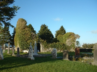
Cargin Cemetery, perched on a hill overlooking Cargin Castle and Lough Corrib with Illauncarbry just offshore is in a spectacular setting. The old graveyard was a circular enclosure about 70 metres in diameter. Within the boundary, the walls of a medieval chapel are situated which were in ruins when the first land surveys were undertaken here in the 1630s. Cargin is a civil parish which was once based on an old church parish and this was the focal point of that parish in medieval times. According to the Archaeological Inventory of Co. Galway, a Children's Burial Ground exists within the ruined walls of the church. This does not tally with local tradition however. A newer cemetery, to the west of and adjacent to the old, was opened in the 1960s.
Cargin Cemetery is old, probably the oldest extant man-made structure in this area since the birth of Christ - even older than Cargin Castle a few hundred metres to the south-west. The chapel is probably of 10th/11th century origin while the Norman castle dates from the 13th century.
Today only the original east and west gables along with the southern wall form part of the original structure. There is no legend of any saint associated with this site ( as St. Fursey was with Killursa and St. Enda with Killeaney, for example ). In fact William Wilde had this to say about Cargin church in 18671 :
"The old church of this parish is of no great interest or antiquity, and neither to it nor to this parish itself is the term "Kill" applied, but the ruin is called Séipéal an Carraigín, "The Chapel of Cargin," and in all probability it was a chapel of ease to some of the saints' churches in the neighbouring parishes. Around it are the remains of a circular rath, and beside it a Killeen, or children's burial ground, of which class of cemetery there are great numbers in the West, but especially along the shores of Loughs Corrib and Mask."
The 1840 Ordnance Survey and 1855 Griffith's Valuation maps indeed show a Children's Burial Ground to the southwest of the old circular enclosure, in what is either now a local farmer's field or just inside the wall of the south-east corner of the new cemetery. There is no surface indication of this Lisheen. Local tradition also states that unbaptised children were later buried east of the ruined chapel within the boundary walls of the graveyard as late as the 1940s, quite unusual in itself. The earlier map also shows a 'cave' in the north-west corner of the cemetery and local folklore states that it was the entrance to a tunnel that connected the cemetery to the Norman castle on the lakeshore several hundred yards to the south-west. The cave opening was obviously closed in when the National School was built nearby to stop curious children exploring a dangerous underground cavern.
Medieval History
The Books of Survey and Distribution2 show entries for several townlands in the Cargin area. Lugganvoghannon ( Luggawannia ), Ballyconlagh ( Ballyconlought ) and Baltiheile ( Ballyhale ) are listed. The most interesting entry however is for Cargine ( Cargin ) which lists it as "142 acres good", "184 acres wooded" and "56 acres bog". What ties down this entry precisely is the following statement :
"A Small parcell of Gleabe whereon doe Stand the ruinous walls of a decayed Chappell within which Some burials have been lately made"
The Church is actually marked on Petty's 1683 map of Galway - see map below with Cargin highlighted.

It is also interesting to note that these townlands were not listed under Killursa parish but in Annaghdoone ( Annaghdown ) parish. Therefore it is reasonable to assume that Catholic parish topography was much different in 1641 than it is today. Annaghdown was a diocesan centre until the 15th century when it was absorbed into the Archdiocese of Tuam. It now transpires that Cargin was indeed the seat of the Archdeacon of Annaghdown diocese until its disbandment. The old civil parishes once coincided with church parishes but as the church in Cargin was in ruins in 1641, the Cargin church parish must have existed long before this time ( 10th to 15th centuries ). Cargin is mentioned in an Edwardine Taxation3 list in 1306 and again in the land grant to the Earl of Clanricarde in 1611.
Last 200 Years
In the late 18th and early 19th centuries, as a consequence of large population shifts due to famine and emigration, the Catholic church reorganised its parish system and now all the Cargin townlands south-west of Headford are in the Catholic parish of Killursa & Killower - some in each of two half-parishes ( Claran and Headford ).
Most families from the local townlands have burial plots in Cargin old cemetery. They are clustered to the south and west of the ruined chapel with the main centrepiece being the large celtic cross standing over the railed crypt of the Lynch-Staunton family - the former landlords of Clydagh Estate which consists of the surrounding townlands, including Cargin. The oldest stone inscription discovered to the present time is dated 1817.
In 1802, the absentee Landlord of Clydagh, Sir George Thomas Staunton, while visiting his Estate commented in a letter4 to his mother in England :
"It is, on the whole, a delightful romantic spot. The Lake, the Islands, the Wood, the distant mountains, the ancient church and castle form a 'tout ensemble' of picturesque beauty seldom to be met with anywhere, especially in Ireland."
Another noteworthy grave in the old cemetery is that of Louis Darcy, a freedom fighter from the Irish War of Independence. He was shot by the Black and Tans near Oranmore in March 1921. He was Commandant of the North Galway Brigade of the IRA. Darcy was just 23 years old. His gravestone is inscribed in Irish and a major commemoration ceremony took place at his graveside in 1966 to mark the 50th anniversary of the 1916 Easter Rising.
Work commenced in 2001 to make a large car-park to the roadside of the old cemetery, in land kindly provided by a local farmer, and to make a proper entrance and pathway into the old and new cemeteries from that location. As has been the case over the years with Clydagh National School, the Clydagh Gymkhana Committee and the local Loggawannia Group Water scheme, this is a community effort with most, if not all of the labour, being supplied on a voluntary basis. A plan is now in place to raise funds and to care for the cemetery on an on-going basis. Likewise a plan is being devised to initially investigate and later preserve the ancient church ruins and other archaeological items of heritage concerning the cemetery. The latter work is kindly supported and partly funded by the Irish Heritage Council and Galway County Council Heritage Department.
Over 1,000 years later the history of Séipéal an Carraigín is still being written!
Text and Photographs are Copyright © 2004, Michael H. Carroll