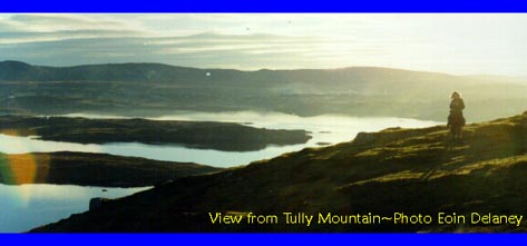
| Brief Description: This is an easy walk with relatively little navigational difficulties. The summit of Tully mountain offers views onto the islands of Inis Bofin and Inis Turk to the west and north west, and the Ben Choona mountain range to the south.
Route Description: From the quay, walk towards Tully mountain for about 1 km. You should notice a grassy mound on the East side of Tully. Access to the grassy mound is through the gate or over the fence. The ascent along this grassy slope is a fairly easy one. This brings you to the cairn at the summit. This is a good place for a short break, taking time to admire the view. Continue South West along the broad summit ridge for another 1 km or so. The summit ridge consists of small lakes or tarns, tiny valleys and rocks. Continue further west to the next summit (1 km). You can begin you ascent from this point to the end of the small road at Leitir Beg (Leitir Beag). Once you have reached the road walk along it back to the quay. I recommend Veldon's pub in Leitir Frack (Leitir Fraic) for good food and drink. |