Return to the village by turning left on the N56. On the right 60 yds. Further is St. Columba's Church (Catholic, 1896) with the national school opposite. Further again, at the junction with the Hornhead Road, is the Garda Station. Holy Trinity Church hall, school and church (C. of Ireland) is a few yards up the Hornhead Road on the left.Top
B. Kill Church (2 miles) WALK WITH CARE out of Dunfanaghy on the N56, Letterkenny direction, passing on the right the Presbyterian Church. Turn right at the first side road, about ẅ mile from the village. Along this road is the ruined former parish church, with a fascinating epitaph on a tombstone inside the church. Just before the church and on the same side look out for a small iron gate leading to a grassy enclosure: this is the Famine Graveyard. Continue walking along the road and turn right at the T-junction. A short walk takes you back to Dunfanaghy Market Square with its distinctive Market House.Top
2. Ards Forest Park and Friary (4 miles) A booklet is on sale at the park gate showing the many trails in the park and walks can vary from short strolls to the 8 mile circuit of the whole park. This walk links most of the beaches and begins at the car park where there is a map. Take the sign-posted path to the beaches. At the log shelter leave the path and follow the track along the headland on your right, climbing up towards the wall on the brow of the hill. Follow the path through a gate and descend to the beach on your right. At the end of the beach a path leads to a gravelled walk which ends at the Friary. Return by the same route or walk back a shorter way through the forest park by taking the road to the right of the Friary and then the second turning to the right. Walk this narrow road for 400 yds. And take the second gate to the right from where the path leads directly and very steeply down to the car park. Beautiful beaches, superb views.Top
Horn Head This head-land projects north from the village of Dunfanaghy and bounds Sheephaven Bay on the west. It has 600" chiffs jutting out into the Atlantic and is home to several colonies of sea birds. There is a tarred road around the eastern side with magnificent views of the sea, mountains, islands and the village of Dunfanaghy.
 3.
Hornhead -road walk (Longer version 7 Ẅ miles, short
version 4 Ẅ miles) Longer version begins in Dunfanaghy. Take the Hornhead
Road which forks to the right at the southern end of the village and follow
round to the road on the left sign-posted Hornhead. The shorter version
begins here where parking is possible 100 yds. Beyond the junction. Walk
up the road ahead ignoring the signed road to the left and follow this
circular road around the headland WITH CARE.
3.
Hornhead -road walk (Longer version 7 Ẅ miles, short
version 4 Ẅ miles) Longer version begins in Dunfanaghy. Take the Hornhead
Road which forks to the right at the southern end of the village and follow
round to the road on the left sign-posted Hornhead. The shorter version
begins here where parking is possible 100 yds. Beyond the junction. Walk
up the road ahead ignoring the signed road to the left and follow this
circular road around the headland WITH CARE.
A detour to the sign-posted coastguard station is recommended and it is
possible to walk further (an additional 2 miles) around the cliff path
to the ruined signal tower and even to the horn itself. For this STRONG
SHOES AND GREAT CARE NEAR CLIFF FACES ARE NEEDED. THIS PARK OF THE WALK
IS NOT SUITABLE FOR SMALL CHILDREN. Steep gradient, superb views.Top
To do the latter you can begin at the visitors centre or take the bus for the 1 Ẅ mile journey to the castle. Take the path behind the castle and walk along the lake beware of midges on windless days in summer! This path continues beyond the end of the lake and climbs right to the head of the glen, passing several waterfalls; from the castle to the end of the path and back again is about 7 miles. Another lovely walk is from Glenveagh to Gartan via a gravelled path which winds gradlually over the hill between these two very different lakes - a lovely taste of true Donegal moorland. The path starts about 400 yds. before the castle.
To Gartan and back is about 8 miles but you could arrange to be met at the Glebe Gallery at Gartan which is reached by turning right when you reach the main road at Gartan and walking 400 yds. Wonderful scenery and interesting places to visit.Top
 which
is all downhill on mainly quiet roads. .Leave one car in the car park at
Doe Castle (off the road from the N56 to Carrigart) and drive in the other
car towards Carrigart. Cross Lackagh Bridge and take the road to your right
sign-posted Glen. At Glen turn right, then immediately left, following the
road to Lough Salt.
which
is all downhill on mainly quiet roads. .Leave one car in the car park at
Doe Castle (off the road from the N56 to Carrigart) and drive in the other
car towards Carrigart. Cross Lackagh Bridge and take the road to your right
sign-posted Glen. At Glen turn right, then immediately left, following the
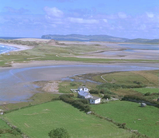
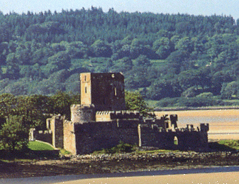
road to Lough Salt. The road climbs to the Lough and follows it along to a parking bay which gives magnificent panoramic views of Sheephaven Bay with a backdrop of mountains from Muckish to Errigal. Park here and walk down to Doe Castle, retracing the route taken by car. The old-fashioned pub in Glen is well worth a visit, as is the castle and nearby graveyard. Drive back from Doe to collect the car at Lough Salt.Top
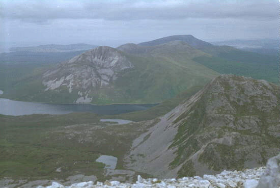 moderate
fitness, walking boots and a wary eye on the cloud base. NOT SUITABLE FOR
YOUNG CHILDREN and young adults may need to be supervised closely at summit.
Access is from R251, off N56 at Dunlewey. About 2 miles beyond the Lakeside
centre a sign (walking man) indicates start of the walk, through any route
up the grassy / boggy slope is feasible.
moderate
fitness, walking boots and a wary eye on the cloud base. NOT SUITABLE FOR
YOUNG CHILDREN and young adults may need to be supervised closely at summit.
Access is from R251, off N56 at Dunlewey. About 2 miles beyond the Lakeside
centre a sign (walking man) indicates start of the walk, through any route
up the grassy / boggy slope is feasible. Going up becomes hazardous about a third of the way up where the only route possible is along a scree-strew track. The first summit is connected by a narrow ridge to the second, difficult in strong wind. Choose a clear day with maximum visibility to give the magnificent views which make the hard climb worthwhile.Top