 |
You can follow Inishbofin's history chronologically or use the
following menu to see a specific period (left column). You can also go to the webpages
devoted to the main buildings of the island's heritage (right column). Don't forget to
read the death of Inishark (article from the Daily Mirror of 1960). |

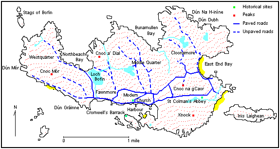
The offshore islands of Inishbofin (Inis Bó Finne), Inishlyon (Inis Laigleán) and
Inishark (Inis Áirc) lie roughly 8 km of the Northwest Connemara coast. Of the three,
Inishbofin is the largest measuring approximately 5.5 km long by 3 km wide. It is also the
only one inhabited today. The islands are strategically located midway along Ireland's
western sea routes.

| The origins of the island's initial colonisation
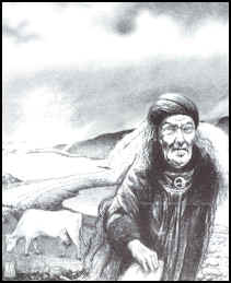
are still obscure. The most common and basis version relates how two fishermen lost in
fog, landed on an enchanted island and lit a fire. The flames broke the spell and the mist
lifted to reveal an old woman driving a white cow along a shingle beach, which ran between
a lake and the sea. She was observed to strike the cow, whereupon it turned to stone.
Another tradition has that the old women and the cow emerge from the lake every seven
years or alternatively to forewarn of some impending disaster. The lake in question is
Loch Bo Finne (Lake of the White Cow) in West Quarter village. |
|
Whatever the truth of the legend, it is clear that the
islands have drawn fishermen, farmers, monks, soldiers and adventurers for over 6,000
years. The population has fluctuated widely over the millennia surging to a peak of
sixteen hundred people prior to the great famine in the mid-nineteenth century. It has
fallen steadily ever since. In 1991 there was a slight increase again to the present
figure of 212 persons.
It is not yet clear when settlement on these islands
commenced. In contrast to the Connemara mainland the island has yet to produce diagnostic
evidence of a Mesolithic presence and until now displayed only circumstancial evidence for
a significant Neolithic presence. There is a marked absence of typical Neolithic and
Bronze Age ritual and burial monuments, such as megalithic tombs, stone alignments or
standing stones. It would appear that the social, economic and religious conditions may
have been different from those pertaining on the adjacent mainland where these monuments
were abundant.
These islands possess an abundance of natural
resources, large fish stocks, fertile soils, a plentiful supply of fresh water and a
superb and easily defended mile long harbour. In addition substantial deposits of valuable
soapstone or steatite are present. In times past this would have been a invaluable
non-food resource for trade and exchange. This malleable, easily worked rock was a highly
prized substance and is commonly found in Early Christian and Viking age sites. An old
soapstone quarry is still pointed out on the shore in West Quarter and until recently
island fishermen used soapstone to make weights for their nets.

 Kitchen Middens
These islands possess a number of Midden sites though they
remain undated as yet.
Possibly the earliest remains of human habitation on the
islands were evident in the sandhills opposite Inishlyon in the town land of Knock. During
the Clare Island Survey of 1911-1914, it was noted that these middens contained charcoal,
peat quantities of limpets, periwinkles, oysters, mussels and broken bones. A hammer stone
was also found at the same position. This hints at a possible early date for these sites.
However, these middens are almost non-existent today due to
coastal erosion and intensive rabbit habitation. Other sites have been identified in Braid
at the south end of the Harbour.
 The neolithic
period
Despite the apparent absence of Mesolithic and Neolithic
sites it is clear from analysis of lake sediments that Neolithic sites communities had an
impact on the landscape of these islands. The presence of a saddle quern in the town-land
of Knock provides sound archaeological evidence in support of the sediment analysis
results.
| The field systems that were uncovered in the more marginal
and rough land of Bofin may date from the Neolithic to Medieval times. These consist of a
profusion of substantial house sites with coeval field systems, terraces and fulachta
fiadha. Two of the more important settlement complexes are located on the south side of
Inishlyon and the north shore of Inishark. Those and the site in West Quarter are pre-bog
sites and suggest an older period than others on the island. The field systems located at
Middle Quarter, Knock hill and Bunamullan suggest intensive farming and a large
population. |
 |
The ancient stone terraces are thought to be of Bronze age
origin. The widespread distribution of these terraces, house sites and fulachta fiadha
point to a huge expansion of population during the late Bronze Age which may have led to
marginal areas being taken in to cultivation. This in turn may have resulted in the
exhaustion of the island's more fragile soils, to their abandonment and subsequent
envelopment in peat.
Coastal Promontory Forts thought to be of The Iron Age are
common on these islands, the most dramatic been Dun Mor in West Quarter. This fort
"consists of a wall of masonry, curving around a natural terrace, half way up the
slope of the headland with several hut sites around the low hill eastwards from the
Dun". The rubble from the original defence wall is still visible. Such forts were
built for defence purposes along the cliff edge with a complete view of the surrounding
water.
There are at least 3 others on Inishbofin, Dun na h-Inine,
Dun Dubh, and Dun Graine. The latter is said to have been occupied by Graine Uaile who
from there defended the entrance of the harbour against intruders. The discovery of a
medieval window fragment on this site recently provides us with the sole surviving
artefact of this long lost O Máille Castle.

Close to the tiny harbour in Inishark there are a number of
feature associated with the monastic site founded by St. Leo. There is a small cashel
called Clochan Leo, traces of a medieval Church Foigh Leo and a small holy well, Tobar
Leo. With regards to Inishbofin St Colman dominates from as early as the 7th
century. He was of Connacht origin and defended the Celtic Custom on the dating of Easter
at the Synod of Whitby in 664. The Synod condemned the Celtic Way and this Paschal
controversy led Colman to leave Lindesfarne with all the Irish Monks and thirty English.
They sailed to Bofin via Iona and landed here in 665.
In the townland of Knock they established another a
monastery. Before long discount arose within their community between the Saxons and the
Celts. Colman removed the English to the mainland of Mayo and established another
monastery there. He died there on August 8th in 674.
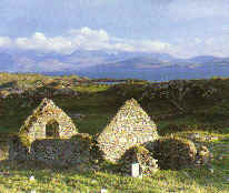
| Today there remains a ruined
stone chapel on the site of the original St Colman's monastic site, which dates to the
14th century. The original structure was probably a wooden one was sacked and burned in
1334. There is also a bullaun stone and two early crosses. |
 |
St Scaithin is also reputed to have had a settlement on
Inishbofin. This site is situated in West Quarter in the old children's burial ground. In
the medieval period these islands like most of Connemara lay beyond the direct Norman
influences and were held alternatively by the O' Flaherty and the O Malley sea lords. The
islands no doubt participated in the extensive business of trading and raiding that
typified maritime pursuits in the medieval period along the western seaboard.

The strategic importance of these islands ensured that they
attracted the attentions of both National and English forces during the major upheavals
caused by the 1641 Rebellion. During this time Inishbofin became a pivotal stronghold in
the West and was the last to fall.
Royalist forces held out here with French aid from the Duke
of Lorraine and made a last ditch campaign of resistance. After some initial success,
which included retaking the Aran Islands, the resistance finally crumbled and the islands
surrendered in somewhat controversial circumstances. The Cromwellian regime built the
imposing and wonderfully intact Star-Shaped artillery fort at the mouth of the harbour,
circa 1656. It is known locally as Cromwell's
Barracks and Don Bosco's fort. The latter is reputed to have been a Spanish pirate and
ally of Graine Uaile. Together the pair kept out intruders from the harbour. Being
raiders, they could also use the same technique to trap merchandised ships in the harbour
and avail of their treasures for themselves.
To the east lies an impressive cresentic shaped medieval
harbour, which still stands over 3m in height at low tide.
With the Cromwellian occupation the islands entered a new and
somewhat bizarre stage. The Fort was used as a penal holding for Catholic priests and many
remained until the restoration of Charles 11. During the Jacobite wars the fort was again
in Irish hands and held out until after the battle of Aughrim in 1691, when they
surrendered on good terms to the Williamite forces.

In the eighteenth century, the islands then owned by the
Burkes entered a period of relative tranquillity and benign neglect. The islanders
resorted to the old age practice of ship wrecking and smuggling. A surviving warrant of
1741 gives a fascinating description of the wrecking of a ship, the Kitty Briggs who was
bound for England with a rich cargo from Antigua in the West Indies. She was attacked in
Inishbofin harbour by three O' Flaherty brothers, one being a priest.
In the nineteenth century fishing supported an enormous
population of over 1600 people which included the hunting of seals and basking sharks. The
Irish language continued to be spoken on these islands up to the 1900s when it was
gradually replaced by English. In recent times the growth of the tourist industry has
brought fresh life into Inishbofin and this should revitalise the economic life of this
most picturesque of islands.
Reference:
Inishbofin, Through Time and Tide.
Edited by Kieran Concannon.
Inishbofin Development Association
1993 (Reprinted 1997)
Cost £10.00 plus postage |


