![]()
|
PLACES OF INTEREST IN BANTRY • Armada Exhibition |
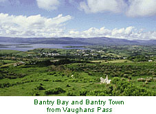
 The town of BANTRY is located at the northern end of the bay to which it gives its name. In olden times called Kilgoban after its patron, St. Goban, the present name Bantry is said to derive from Beant-Mac-Farriola, a descendant of the O’Donovans and O'Mahonys, chieftains of the area.Today Bantry is a market town, port and tourist centre.
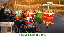
BANTRY BAY Bantry Bay featured prominently twice in the naval history of Ireland; in 1689 when a French fleet entered the bay to aid James II, and again in 1796 to assist the rebellion by the United Irishtmen. FRENCH ARMADA 1796In the late 1700s the Irish patriot Theobold Wolfe Tone of the United Irishmen, enlisted French assistance to overthrow British rule in Ireland. In December 1796 a French Armada with 15,000 troops left Brest in France for Bantry Bay. However, severe winter weather conditions scattered the fleet and only 19 ships with 6,500 troops arrived in the bay off Bere Island. Fierce easterly gales prevented a landing and blew the ships out to sea. By New Year’s Day 1797, 12 ships with 4,500 troops were anchored off Whiddy Island. After many attempts and failing to land in Ireland, the fleet returned to France. One old frigate, 'La Surveillante' was left behind because of storm damage and was scuttled off Whiddy Island on January 2nd 1797. The story of this ship and the unsuccessful French invasion is related in an exhibition at Bantry House. FISHINGThe main commercial fishing fleet in Bantrv Bay is based at the port of Castletownbere. With a smaller fleet at Bantry, Castletownbere is one of the chief commercial fishing centres in Ireland. Fish species regularly landed include cod, haddock, herring, mackerel, plaice, whiting and shellfish such as lobster, prawn, shrimp and scallop. BANTRY BAY MUSSEL FARMING In recent years Bantry Bay has become the most important area in Ireland for the production of mussels, which are grown on rope rafts in sheltered sections of the bay. Processing for sale takes place in local factories. ISLANDS OF BANTRY BAY 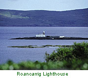 Within the vast open Bantry Bay there are a number of islands. The largest, Bere Island, is inhabited and has a long and interesting history. For many years it was an important British military and naval base. It is used today by the Irish army for training. Garinish Island lies within Glengarriff Bay. It is famous for its Italian gardens, and is well worth a visit by boat from Glengarriff. A low rock, Roancarrig, is the site of the only lighthouse in Bantry Bay. Whiddy Island is the location of a large oil terminal and is home to several families who farm the fertile land. SIGHTSEEING of BANTRY BAY
The oil terminal on Whiddy Island was constructed in 1969 by Gulf Oil. It was established at a time when the Suez canal was closed to shipping. Large crude-oil tankers known as supertankers, sailed from the Middle East via the Cape of Good Hope to the Whiddy terminal to discharge their cargo. With large size and deep draft, many of these tankers could not enter most world ports. However, Bantry Bay could accommodate them. The first oil tanker to discharge at the terminal was the supertanker Universe Ireland. In 1979, the Betelgeuse was the last to discharge its cargo. BETELGEUSE OIL TANKER A single-point mooring buoy for loading and off-loading has been installed since.
|
|
|
Size: A5 (148 x 210 mm) 64 glossy pages (200g/sm) contains over 200 photographs all in splendid colour. Glossy cover with foldout colour map over two pages. Price |
© Earleybird Productions 1998
Email
Website Design: C. Nidecker 1999
Email
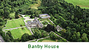 BANTRY HOUSE