|
Carrauntoohil |
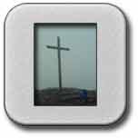
Walk Grade Strenuous with scrambling in places, can be done in less than 5hours at a brisk pace. Access From Killarney take N72 in direction of Killorgan. At Beaufort turn left off N72 in direction of Gap of Dunloe, Kate Kearney's cottage. Continue on this road for a little over 2km and take the right fork at GR(88.0 90.3). Continue on this road for a little over 5km turning left at GR(83.05 89.20). You must pass by an earlier signpost for Carrauntoohil as this takes you to a different starting point. Following left turn at GR(83.05 89.20) proceed to starting point at Lisleibane GR(82.53 87.48) Walk Features Carrauntoohil is the principal mountain of the Macgillycuddy Reeks and the highest mountain in Ireland at 1039m. The Macgillycuddy Reeks is characterised in many places by jagged peak rock structures and knife edged ridges, which provide a type of rugged beauty. It is thought that many of the peaks over 700m have this characteristic as they escaped the glacial erosion of the last ice age. One of the photographs below illustrates this type of characteristic. The existing metal cross on the summit was erected in 1976 to replace the previous wooden one which was first put up in 1950.The surface of the cross has a blackened charred appearance as a result of numerous lightening strikes. This walk, which follows a standard route up and down, does contain one or two areas, which are difficult to negotiate. For reasons of safety an experienced mountain leader should accompany walkers. This area is covered in OS Discovery Series Map No 78. Walk Details From Lisleibane GR(82.53 87.48) walk through farmers gate in southerly direction to the hills. Rather than take path on the left cut straight up the hillside and rejoin path again at about GR(82.79 86.98). Follow stony path for about 1.5km as it tracks along the side of the River Caddagh taking you in a southerly direction into the Hags Glen. At about GR(82.13 85.49) move off path in a south-westerly direction towards the mountains on your right. You will now gain height with the stream on your left hand side. Also you are on the north side of Lough Gouragh moving in a more westerly direction. Go around the edge of Lough Couragh without initially trying to gain height.As you gain height you will need to do some climbing over rocks and boulders with a little scrambling . After this initial climbing you should get to GR(80.91 84.89). Here the ground is flatter and you can see a scree track leading up with a small water channel running down the slope to the right.Follow the scree track ahead which takes you up to another level at GR(80.61 84.75). Your objective is to get to a small lake GR(80.31 84.82), which involves a further climb of 85m from the last grid reference. This lake is at 695m and could be a suitable place for a break. From the lake swing up to your left into a very wide gully which is the initial approach to O'Sheas Gully.Do not take the gully directly facing you as you look across the lake.This part of the climb involves an ascent about 240m in total, mainly on scree tracks with patches of grass which is reasonably safe, but can be quite strenous. The wide approach to O'Sheas gully leads you to a choice of three gullies to reach the summit. O'Sheas gully is to the right and is straightforward to climb. The other gullies to the left which are known as Curved gully and Central gully, are more difficult and dangerous.When you reach the top of O'Sheas gully at GR(80.09 84.54) turn to your left and you will have about another 110 metres in height to reach the summit.Care is required at this part of the walk as you may experience strong winds as you leave the shelter of the gully. From the summit follow a very stony path down in a south-easterly direction. At approximately GR( 80.53 83.87) go to the left away from the path. Continue in a north-easterly direction and you will pick up a small track at about GR(80.68 84.13), which will take you towards the heavenly gates. You will now have some steep sections to descend as you follow the path down. A good view of Lough Gouragh will open out on you right hand side. At the top of the heavenly gates GR(80.74 84.43) there are some good photographic opportunities but great care must be taken with regard to safety. As you descend from the heavenly gates you will pass a small rescue hut on your left. Continue on past the hut and you will need at one stage to track back in order to take a path down the side to get down to a lower level, also you will have to get down an awkward rock section, which you had climbed earlier in the day.Eventually you will meet the path you came up on at about GR( 81.01 84.87). The path to Lisleibane is now fairly straightforward as it is an exact retrace of your incoming path. |
Click on any Image to Enlarge it. |
|
|
|
|
Lough Callee |
Scree Track and Water Channel |
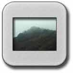
Jagged peak formation |
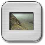
Approach to O'Sheas Gully |
 |
 |
 |
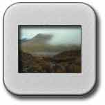
The cross in the mist |
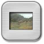
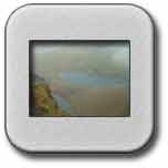
View of Hags Glen |
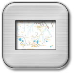
Route of Walk |
![]()