Many Thanks to new member Brian McNamara who got this
page going. It is a work in progress as Brian is a 'Southsider'
and we should give him 2 points every week for just
finding the Sign on !!!!!
Thanks to Brian for the sketches & the map references
and to Fred for precise lap distances & Maps
<Link to Lap & Complete Race
distances in Miles & Km>
_________________________________________________________________________________________________________________
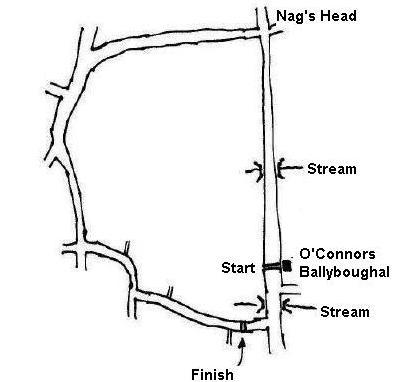
Ballyboughal CP
(? x 9mile laps)
(Early season 2 laps, mid season 3)
<Detailed>
How
to get there from Swords:
Traveling North up the Main St of Swords, turn left at
the Castle in the direction of Ashbourne on to the
Rathbeale Road. After 2.5 Miles there is a RH turn
signposted Ballyboughal. Ballyboughal is a small village
about 3 miles up this road (direction of the Naul).
Church on the left, sign on & park 100 yards up hill
at Ballyboughal GAA Club
How to get there from M50
Take the exit off the M50 for the M1 Belfast.
Take the exit off the M1 for Rush/Skerries/Donabate.
Turn right on the roundabout at the end of the exit
heading for Balbriggan.
Go straight past the turn off (Blakes Cross) for Rush and
Skerries, there will be an Esso Service station on your
left called Blakes Cross Service station.
About 100 yards after this station there is a left hand
turn signposted for Balyboughal, take this turn.
Keep going straight all the way until you reach
Balyboughal village.
Route Description:
Start outside O'Connor's pub, facing north. Go up the
drag (& hill) to the Nag's Head (need to dig deep
just before the corner!), and turn left , where you'll
quickly descend. Then there's a rise again, and you come
to the second turn left (a sweeping turn at the bottom of
the decent). Keep going along this road (a little bit
windy, so keep well in to the left), until you get to the
next turn, another left with a slight rise out of the
corner (at Xroads). Keep going along here , slight
sweeping right hand bend and then left, follow the road,
to the left hand bend at the 1798 monument, around this
bend and you're in the finishing straight straight, or on
the first lap you get to the bridge in Ballyboughal and
you're turning left again up the drag.
_________________________________________________________________________________________________________________
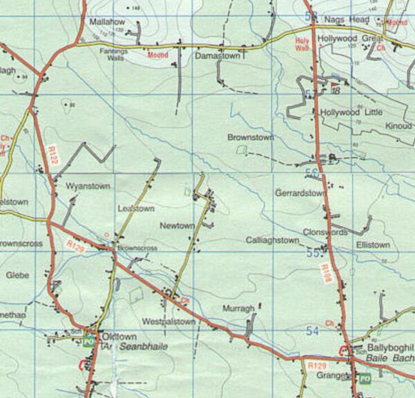
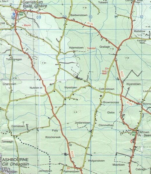
Oldtown 10 MileTT (or Oldtown CP)
(Sign
on & Park at Oldtown Church - Starts & Finishes
at Graveyard)
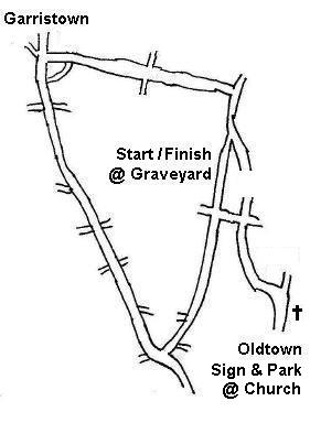
<Detailed>
How
to get there:
Traveling North up the Main St of Swords, turn
left at the Castle in the direction of Ashbourne on to
the Rathbeale Road. Keep travelling down this road, past
the turn for Ballboughal, past the Rolestown Inn, past
the Texaco Garage and 4.7 Mile from Swords, you come to a
Xroads with the right turn signposted 'Oldtown'. Turn
right and after about 2.5 miles you will come to Church
on your RHS. Sign on & park here.
Route Description:
Starts and finishes from the Graveyard. This is approx 1.5
miles from the Sign on. From the Church, down to the next
Xroads, left, up a slight rise and right
at the next Xroads.
Starting from the Graveyard, after about 300 yards you
are out onto the backend of the Ballyboughal circuit.
Take the next left at the next signposted 'Garristown'.
Couple of miles up this road and you come up a slight
hill into Garristown where you turn left. Next section
has some fast and slightly windy bits until you take to a
very sharp left off the main road. The sign at this
junction points to Swords 11km (but you're not going to
Swords!!!! - you're are turning left).
Straight on from here, after a about 2 miles thru a
Xroads to finish at the Graveyard.
(Course is 'slightly' longer than 10 Miles).
________________________________________________________________________________________________________________
Bog of the Ring
CP
(Early season 4 laps, mid season 5)

How
to get there:
Travel North on the new Motorway, and take the
turn off for Balbriggan which would bring you into
Balbriggan from the south side of the town. You come off
the Motorway on the left hand slip road, come to a small
roundabout, turn right to coss over on the
bridge and turn for Balbriggan on the other side. You are
now on the old Balbriggan Road. A few hundred yards and
straight through a small roundabout and past this there
is a left turn for Bog of the Ring and Ring of Commons
Sports Centre (for start & sign on)
---------------------------------------------------
Corduff CP (? x 12 mile laps + 3
miles)
(Early season 2 laps, mid season 3)
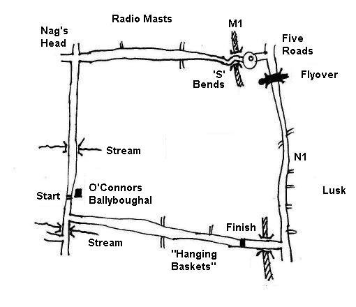
<Detailed>
How to get there
from Swords:
Traveling North up the Main St of Swords, turn left at
the Castle in the direction of Ashbourne on to the
Rathbeale Road. After 2.5 Miles there is a RH turn
signposted Ballyboughal. Ballyboughal is a small village
about 3 miles up this road (direction of the Naul).
Church on the left, sign on & park 100 yards up hill
at Ballyboughal GAA Club
How to get there from M50
Take the exit off the M50 for the M1 Belfast.
Take the exit off the M1 for Rush/Skerries/Donabate.
Turn right on the roundabout at the end of the exit
heading for Balbriggan.
Go straight past the turn off (Blakes Cross) for Rush and
Skerries, there will be an Esso Service station on your
left called Blakes Cross Service station.
About 100 yards after this station there is a left hand
turn signposted for Balyboughal, take this turn.
Keep going straight all the way until you reach
Balyboughal village.
Route
Description:
Sign on and Start
is in O'Connors pub in Ballyboughal, facing south,
turning left at the bridge in Ballboughal, heading for
the old Swords/Balbriggan road, heading north, turning
left at the Five Roads, up past John Shorts house, on up
the hill, and then descending, arriving at the Xroads at
the top of the Nags Head, and down into Ballyboughal. Two
laps of this circuit and the finish is on the circuit
past Ballyboughal, past the 'Hanging Baskets' and on a
bit more, with the finish just before the flyover over
the motorway, road widens slightly, slight rise with good
visibility.
Safety
considerations for this particular route:
1. When coming out on to the Swords, Balbriggan road,
keep well into the left.
2. Caution on the left turn at the top of the Nags Head
as you will be decending. Both these turns are a good
distance from the finish so no need to take unneccesary
chances. Also there is a square manhole cover on this
corner (slippery when wet).
3. After fiinshing please take a minute or two before
riding back along the route as other riders may be still
'steaming' towards the line.
Alternative Finish:
As per 2004 & 2005 Swords Grand Prix and proposed to
be used in this years Swords CC Club C/ships would finish
on the Nevitt ie on the long climb.
---------------------------------------------------
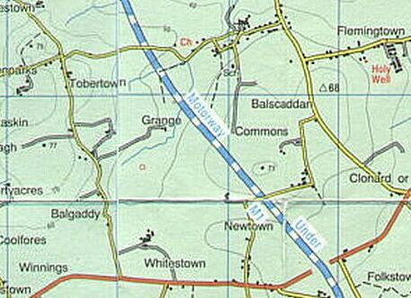
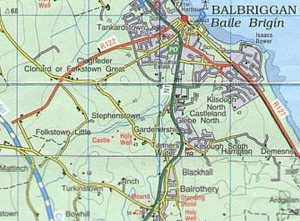
Balscadden CP (New
Course 2006)
4/5/6 laps (5.71 miles & .75 mile to finish)
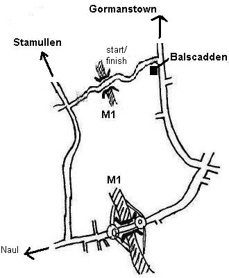
How
to get there:
Travel North on the new Motorway, and take the
turn off for Balbriggan which would bring you into
Balbriggan from the south side of the town. You come off
the Motorway on the left hand slip road, come to a small
roundabout, turn right to coss over on the
bridge and turn for Balbriggan on the other side. You are
now on the old Balbriggan Road. A few hundred yards and
straight through a small roundabout and straight. The
Balrothery Inn is on the RHS about a mile up this road.
About 300 yards past the Balrothery in there is a left
turn signposted Balscadden & Gormanstown . (This is Turn 1 on the Balrothery CP). Follow this road up
to the Xroads, straight accross, up a long drag. At the
crest of the hill there is a left turn for Balcadden.
(Alternatively: Travel north through Balbriggan,
past the town turn left at 'The Hunstman Inn'. A
few hundred yards up this road there is
right hand turn for Stamullen. Ignore this turn but
instead keep going with Gromanstown College on your right
up the hill. At the top of the hill turn left for
Balscadden.
Route Description:
This race starts (or may start in Balscadden itself) and
finishes on un uphill stretch of road the far side of
Balscadden and travels in a clockwise direction in the
opposite direction to the course we used to use taking in
the other half of the old Stamullen big lap. Starts and
fiinshes on the new stretch of road over the Motorway on
the far side of the village. Up the hill and left,
downhill towards Naul Balbriggan road, through the mini
roundabouts and left up the hill. Top of hill left for
Balscadden, through village, half a mile to the start/finish
line
<Link to Detailed Map>
---------------------------------------------------
Balrothery CP
(Early
season 5 x 4 mileslaps, mid season 6/7)
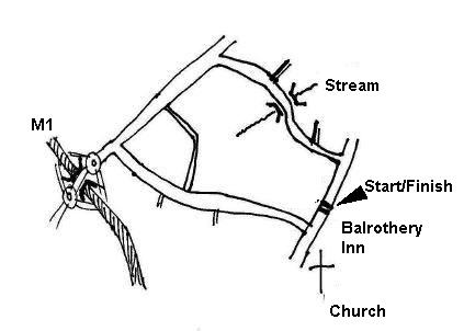
<Detailed>
How to get there:
Travel North on the new Motorway, and take the turn off
for Balbriggan which would bring you into
Balbriggan from the south side of the town. You come off
the Motorway on the left hand slip road, come to a small
roundabout, turn right to coss over on the
bridge and turn for Balbriggan on the other side. You are
now on the old Balbriggan Road. The Balrothery Inn is on
the RHS about a mile up this road.
Route Decription:
The race starts & finishes accross from The Pub and
about 200 yards towards Balbriggan. It takes
the first left, climbs a very short hill, quick & and
sharp decent and and up another short hill, left at
the next xroads(although it looks like a T-Junction on
the map?). A draggy bit of road and left again. Slight
downhill, slightdrag, and slightdown hill again coming
out facing the Balrothery Inn, and then about 300 yards
to the start finish line. Lap is 4 miles.
---------------------------------------------------
Stamullen CP (The big lap)
3 laps: 24 miles
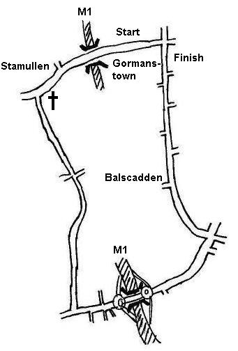
<Link to Detailed Map>
How
to get there:
Travel North on the new Motorway, and take the
turn off for Balbriggan which would bring you into
Balbriggan from the south side of the town. You come off
the Motorway on the left hand slip road, come to a small
roundabout, turn right to coss over on the
bridge and turn for Balbriggan on the other side. You are
now on the old Balbriggan Road. A few hundred yards and
straight through a small roundabout and straight. The
Balrothery Inn is on the RHS about a mile up this road.
About 300 yards past the Balrothery in there is a left
turn signposted Balscadden & Gormanstown . (This is Turn 1 on the Balrothery CP). Follow this road up
to the Xroads, straight accross, up a long drag. At the
crest of the hill there is a left turn for Balcadden, but
are going straight down the hill. Slight bend at the
bottom, and you are in the finishing straight. College on
left, shop on the right. Sign on is around the next left.
(Alternatively: Travel north through Balbriggan,
past the town turn left at 'The Hunstman Inn'. A
few hundred yards up this road and turn
right for sign on)
Route Description:
Starts heading for Stamullen, takes a left, narrow &
bend, and onto the climb. Down far side and left, flat
& fast, next left and up a drag. Fast decent, slight
bend, 400 yards to the finish line, next left comlpetes
first lap.
_________________________________________________________________________________________________________________
Stamullen -
Balscadden CP (The smaller lap)
6 laps: 26 miles

<Link to Detailed Map>
How
to get there: (Sign on Start & Finish same as
Stamullen CP)
Travel North on the new Motorway, and take the
turn off for Balbriggan which would bring you into
Balbriggan from the south side of the town. You come off
the Motorway on the left hand slip road, come to a small
roundabout, turn right to coss over on the
bridge and turn for Balbriggan on the other side. You are
now on the old Balbriggan Road. A few hundred yards and
straight through a small roundabout and straight. The
Balrothery Inn is on the RHS about a mile up this road.
About 300 yards past the Balrothery in there is a left
turn signposted Balscadden & Gormanstown . (This is Turn 1 on the Balrothery CP). Follow this road up
to the Xroads, straight accross, up a long drag. At the
crest of the hill there is a left turn for Balcadden, but
are going straight down the hill. Slight bend at the
bottom, and you are in the finishing straight. College on
left, shop on the right. Sign on is around the next left.
(Alternatively: Travel north through Balbriggan,
past the town turn left at 'The Hunstman Inn'. A
few hundred yards up this road and turn
right for sign on)
Route Description:
Starts heading for Stamullen, takes a left, narrow &
bend, and onto the climb. Left at the top of the climb,
down a narrow road, fast bit where you cross the motorway
and slightly uphill through the small village of
Balscadden, then left at the T-Junction and down far side.
Fast decent, slight bend, 400 yards to the finish line,
next left comlpetes first lap.
_________________________________________________________________________________________________________________
Batterstown :
Mullagh
(2
Laps of Mullagh circuit -25.6 Miles)
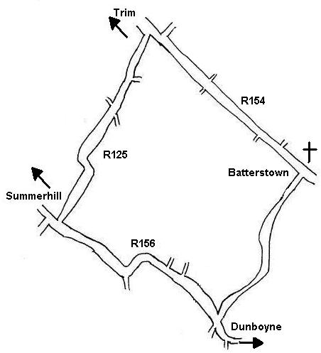
This course is sometimes used for
our Club 25 Mile TT, but more usually of late we use of
the Dunsany (Green sheds) circuit using a Start/Finish
line that is approx half a mile past the disused Garage
in Batterstown. This course as used by the IVCA is
exactly 25 miles
25 Mile TTs
(Latest most accurate - Out & Back)
In 2008 we used the IVCA measured course for the 25 mile
TT. Sign on was in Batterstown but the Start and Finish
are clearly marked 2km on the Dublin side of the road on
the Dublin side of Batterstown. Note the Start and finish
are slightly staggered by approx 10 yards.
The TT travels 12.5miles out to the first small
roundabout short of Trim
How
to get there from M50:
Come off the M50 at Blanchardstown and travel
north in the direction of Navan. Through the first
roundabout at Blanch, past the turn offs for the
Blanchardstown Centre and past the turn off for Clonee.
You should now be past the end of the Dual Carriageway.
Past next left (which would bring you into Dunboyne),
past two more minor left turns still travelling north.
Just past the major right turn (now served by a new
roundabout) whch would bring you to Fairyhouse/Rathoath,
take the left turn heading for Trim and Batterstown is
approx 3 miles up this road. Park & sign on &
start finish just past the Church on the RHS.
For the record the point where you turned off the Navan
road heading for Batterstown is called Black Bull (although
you wont see this on any sign post)
How to get there from Swords:
Top of Main St, turn right at the Castle and
travel along the Rathbeale Road all the way accross until
you come to the Ashbourne Road, where you go straight
accross roundabout and head for Rathoath. Into the
Village and take the left turn, past Fairyhouse and keep
going until you come ot the Navan Road. (now served by
new rounabout) . Take the exit straight across onto the
Trim road. Three miles from here (Black Bull) to
Batterstown.
Route Description:
If you're looking for a fast 25 - forget it!!!! The
course is 2 laps of the Mullagh which includes a wee bit
of a hill and its a little longer than 25 Miles (all good
training though). Course starts at the Old Garage,
direction of Trim and takes a left after about 3 miles.
Slight downhill, and bit of a climb. Accross to the
Dunboyne/Summerhill road, left in the direction of
Dunboyne and left for Batterstown after about 4 miles
coming out facing the Church to complete lap 1.
A good testing course which sometimes is used for CP's ,
so its worrth doing even if you hate time trails!!!!!
_________________________________________________________________________________________________________________
Batterstown :
Green Sheds (Dunsany)
(3
Miles to Green Sheds - 10 mile laps)
(2 lap
race=26 miles)

How
to get there from M50:
Come off the M50 at Blanchardstown and travel
north in the direction of Navan. Through the first
roundabout at Blanch, past the turn offs for the
Blanchardstown Centre and past the turn off for Clonee.
You should now be past the end of the Dual Carriageway.
Past next left (which would bring you into Dunboyne),
past two more minor left turns still travelling north.
Just past the major right turn (now served by a new
roundabout) whch would bring you to Fairyhouse/Rathoath,
take the left turn heading for Trim and Batterstown is
approx 3 miles up this road. Park & sign on &
start finish just past the Church on the RHS.
For the record the point where you turned off the Navan
road heading for Batterstown is called Black Bull (although
you wont see this on any sign post)
How to get there from Swords:
Top of Main St, turn right at the Castle and
travel along the Rathbeale Road all the way accross until
you come to the Ashbourne Road, where you go straight
accross roundaboutand head for Rathoath. Into the Village
and take the left turn, past Fairyhouse and keep going
until you come ot the Navan Road. (now served by new
rounabout) . Take the exit straight across onto the Trim
road. Three miles from here (Black Bull) to Batterstown.
Route Description:
When this course is used for a CP, the Start/Finish is
from the disused garage in Batterstown. Three miles to
the right turn at the Green sheds (ok they are no longer
green!!!) and you are onto the 10 Mile loop. Up past the
shop and its actually the third left (sharpish turn) and
straight down to the T-junction at Dunsany. up a draggy
bit of road to come back onto the Trim road, up a bit of
a rise at Warrenstown, and back to turn left at the Green
sheds to start on lap 2.
When this course is used for a 25 mile TT, there is a
start/finish used by the Vets about half a mile past the
disused gargage with 2 laps of the 10 mile loop making up
the 25 miles
_________________________________________________________________________________________________________________
Boot Inn
( 6
lap race=28 miles)

How
to get there from M50:
Take the exit for the Airport. Turn right at
main Airport roundabout direction of Swords. Turn right
at the next roundabout (just past the Coachmans Inn.
Follow the road until you come to another small
roundabout, taking the first exit, and turn left after
about 100yards. The Boot Inn is about half a mile down
this road.
How to get there from Swords:
Heading from Swords towards the Airport.Turn
right at the Coachmans roundabout, which is the
roundabout before the main Airport roundabout. Follow the
road until you come to another small roundabout, taking
the first exit, and turn left after about 100yards. The
Boot Inn is about half a mile down this road.
How to get there from Ashbourne Road
Heading North from Finglas (N2) direction of
Ashbourne. Turn right at the lights at timber yard. Come
to a roundabout, straight through. Follow road (Airport
Runway on your right) for about 1.75 miles to Boot Inn.
Route Description:
Race starts outside the Boot Inn and takes a sharp left
onto the R122 after half a mile. Long straight (although
map shows a bend) to a medium sized roundaboud when we
once again turn left and travel along with the Airport
runway on your RHS. The finish line is on this stretch of
road. Past the finish line the road turns left and
towards the Boot Inn and so onto the next lap. Laps are
approx 5 miles. On the map the circuit looks square, but
it as it has three turns it feels triangular. This
circuit is flat (& fast!!!) but can be quite
difficult in windy conditions due to the lack of cover.
On a windy day, you get to experience a tailwind,
crosswind & headwind on each lap.
You can be grovelling at 17mph into a crosswind then turn
down the runway leg spinning a 53x12.!!!
________________________________________________________________________________________________________________
Man-O-War(2005 New
circuit)
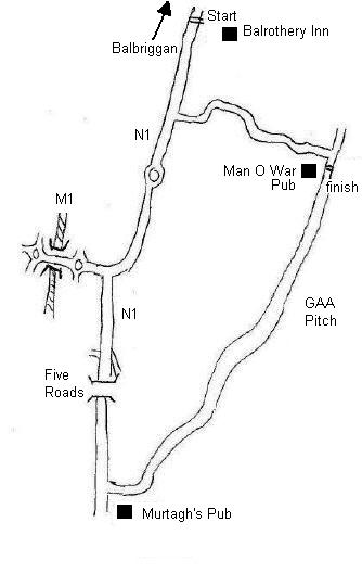
How
to get there:
Travel North on the new Motorway, and take the turn off
for Balbriggan which would bring you into
Balbriggan from the south side of the town. You come off
the Motorway on the left hand slip road, come to a small
roundabout, turn right to coss over on the
bridge and turn for Balbriggan on the other side. You are
now on the old Balbriggan Road. The Balrothery Inn is on
the RHS about a mile up this road.
Route Decription:
This is a new Man-O-War circuit this year (2005) and is
different to both versions previously used in recent
years. The race can start either outside the Balrothery
Inn and heading south (direction of Swords) where it will
turn left at Murtaghs Pub for the first of 3 laps. (Alternatively
the sign on & start can be the Man O War). Finish in
both cases out Man O War pub
Race sets off for Knock Cross,
and proceeds to left turn at
Ballough, just before Murtaghs, along Balrothery-Swords
road.
Ballough to Man O'War - long drag!
Left after Man O'War for fast twisting plunge past
Courtlough back to Knock X.
Finish is at the Man O'War on the fourth lap.
Distances
Balrothery to Knock X - 1.5Km
Loop - 11Km app.
Knock X to Man O'War [finish] - 8Km app.
Any suggested improvements on the
directions or route discriptions appreciated
Hugh @ swordscc@eircom.net
|