Fishing in Mayo is a fisherman's paradise, with its empty river banks, full rivers and the cleanest air and water in Europe. The waterways are set against a backdrop of natural beauty and offer both to the experienced angler and the enthusiastic beginner some of the best fishing in the world.
Rivers:
The River Robe
The river Robe is nearly 40 miles long. It rises near Ballyhaunis
and flows west past Claremorris, through Hollymount and Ballinrobe
and enters Lough Mask north of Cushlough. This rich limestone
river was drained in the early 1980's but has now recovered well
with the help of rehabilitation works carried out by the Western
Regional Fisheries Board. It holds a fair stock of brown trout
- some very good ones to over 6lb. and is a firm favourite with
many dry-fly anglers. It has good hatches of olives and mayflies
and a prolific hatch of sedges. The banks are well developed and
have stiles erected by the fisheries board on all the good trout-fishing
water from downstream of the town of Ballinrobe right up as far
as Castlemacgarrett, near Claremorris.
Access is reasonably good, either from the bridges or at points
where the river flows close to the public road. One stretch is
virtually inaccessible, midway between Hollymount and Foxhall
bridge. Fortunately, this is mostly deep water and holds very
few trout. Another short stretch with no access lies midway between
Robeen bridge and Ballinrobe. Some parts of the river can suffer
from an algae problem in summer.
From Brickens, where the Robe rises to Hollymount the river follows
a course roughly parallel to the road and crisscrosses it at several
points. It is a well known brown trout river and it also has some
very good pike as well as perch and eel. Crossboyne is one of
the better sections for trout. The best areas are from Hollymount
to Hollybrook and from Curraghadooey to Castlemagarrett.
From early April the river offers excellent sport for the Fly Fisher. Hatch includes Olives, May flies, reed Smuts, and a variety of Sedges.
Open Season: March 1 to September 30
Size Limit: 12 inches( 30.48)
No Bag Limit: All Legitimate Angling Methods
The Pollagh River
This river has pike, perch, eel and brown trout. Take the Claremorris/Kiltimagh road, go under the railway bridge at Mureen: the first river that you cross is The Pollagh River. The right hand side (Claremorris to Kiltimagh) is the best for pike.
Coarse Fishing in Claremorris
Here in Claremorris we are surrounded by some of the most underfished coarse-fish lakes in the West. We have pike, trench, bream, and eel all within twenty minutes drive from the town. all fishing is free and no licence is needed. Ireland has no closed season for coarse fish. there is a limit of two dead pike per fisher person, that may be taken from the water.
Lakes
Lough Nanannagh
This Lake has pike, eel and perch. Access is good as you can drive to the side of the lake. Near the Knock road is best for pike.
Drumady Lake
This Lake is very shallow. It has pike, perch and eel. Access is over one field and you fish off what is known locally as "The Island". The lake is on the right-hand side of the Claremorris to Mayo Abbey road.
Mayfield Lake
Mayfield Lake also known as The Station Lake has bream, pike, eel and perch. Access to the lake is from lower James St. or from the railway station.
Clare Lake
Clare Lake, a wild life haven situated within walking distance of the town, Where many plants, mammals, birds and insects - now rare in Europe - can be enjoyed and appreciated.
Derry Lake
Derry Lake is situated in the townlands of Derry, Rockfield, Knockbawn and Maraboy. It's an obivious dividing line between the townland of Knock and Kilcolman (Claremorris). Knock parish is approximately a mile from the parish of Knock. The Lake covers 70 acres of land and ranges in depth from 5 - 40 ft deep. The flooring of the Lake is 2/3 marble-lime and 1/3 bog.
History of the Lake.
Derry Lake is famous for its wonderful display of Forest Oak. There is evidence at the lake that the oak trees have been there for hundreds of years. Derry lake was orginally used as a settlement area for the Celts. They built a Crannog on the lake which was constructed with the oak nearby. The Crannog was discovered in the 80's and a Preservation Order was put on the Lake immediately. The Crannog is on the Rockfield side of the Lake and a hundred yards from the shore. It's possible to get inside through its entrance two feet under the water. Many artefacts were discovered there including arrow heads and cooking appliances.
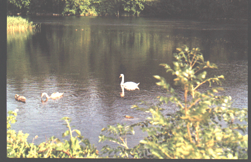
Lough Carra
Lough Carra is a limestone lake, 4000 acres in area, situated
10 miles from Claremorris. The May fly appears in early May and
excellent trout fishing is to be had at this time. Lough Carra
is renowned for its trout fishing, its scenic beauty and the clarity
of its water.
It is the largest marl lake in Ireland. Lakes were widespread
after the ice age but fen vegetation and raised bog have covered
over many of them. The water is mainly produced from springs and
mostly at depths 5 to 10 feet, the 60 foot depth of 'The Black
Hole' ( on arceological trail) is of great interest. The Lough
covers almost 4000 acres. i.e. 1500 hectares and is connected
to Lough Mask by the keel canal ( on Partry- Ballinrobe road).
It is six miles long and two miles at its widest though its ragged
outline contains many promontories and Islands. Doon premonitory
fort almost divides the lake in two. It lies just within the western
boundary of the limestone region. famous for the purity of its
waters and the colours produced by the marl. You can see limey
encrustation on the shore which line rocks in summer when the
water level decreases. Deeper down, the soft soapy chalk prevents
the growth of aquatic vegetation . Even the growth of reeds is
poor. Lough Carra is accredited as of national and international
importance based on its ornithological (birds), botanical (flora)
and zoological interest (about 13 species of wild animals).
Botanists: Amongst the noted Botanist who have reported on the wildlife of Lough Carra are Praeger (1906); Kelly (1973); Shackeiton (1975) Roger Goodwillie and a comprehensive report available from the local Forest and Wildlife Representative. An 1837 record of Flora is also known. The habitats here show an interesting contrast to their more southerly and coastal equivalents in The Burren. The most northerly limit of the Spring Gentian centiana verna, and dense flowered orchid neotinea intacta lies here. There are 24 species of Orchid listed for Ireland 19 of these are found around Lough Carra ( keep this a secret , as in Britain, Orchid fanatics are known to dig up Orchid as their hobby; they die quickly (the orchid I mean! ) when they are removed from their habitat.Lough Carra is a Wildlife Sanctuary. The chain of lakes running from Kiliala Bay to Galway ( Conn, Cullin, Carra, Cask, Corrib) is a regular and habitual line of migration of migrants ( mainly waders and wildfowl) and wandering seabrids when travelling along our western seaboard and as they enter Countries Galway and Mayo. It is the wintering ground for whooper swans, bewick's swans, snipe, woodcock, waders and occasional Geese. It holds the record for 150 pairs of breeding Mallard. The resident population is increased in winter by migrants from Iceland, Canada and Northern Europe. A mallard survey started in 1968 is ongoing and some of those ringed here were found in England, Sweden, Denmark and France. In Autumn large congregations of mallard are to be seen on open sheets of water and in Winter they emerge from the reeds on disturbance where they roost in daytime. Their breeding ground is within a 12 mile radius. During breeding from late February onwards the females are secretive. The main predators are the hooded crow, the greater black-headed gull and when lake levels are low, mammals may gain access to the islands.
![]()
![]()