Drives from Emlough House
Claddaduff-Clifden: This alternative route to Clifden, beside Streamstown bay, is the same length (8m) as through Cleggan. There is a pleasant view of the mountains in the Clifden direction and of the small islands (Friar island, High island) in the Claddaduff direction.
Sky Road: The Sky Road from Clifden out the Eyrephort penninsula provides breathtaking views to the Atlantic over Inishturk (not the larger Inishturk off Mayo) and Talbot island. The road can be taken either as a circle or continued on to Streamstown Bay where it meets the Westport Road beside the turn to Claddaduff.
South to Roundstone: The drive from Clifden through Ballyconneely to Roundstone passes the Coral strand (short of Ballyconneely), great views of the wild Connemara landscape and sea views, and a great view of Dog's Bay. Right at Ballyconneely is the road to Slyne head with Grace O'Malley's castle, Bunowen pier, and Connemara Golf Club. Before reaching Ballyconneely there is a turn to the right which goes out beside Mannin Bay. This leads to some magnificent beaches with great views back to the twelve Bens. The beaches look innaccessible, but if you persevere out a few miles (veering left at the first cross) there is a track to the right steeply down to a gate which leads out to a commonage of grass providing direct access to the beach and a very pleasant walk along the shore.
Roundstone itself is very picturesque and a trip to Malachi Kearns gift shop (famous for his bodhrans)at the old monastery site is worthwile.
The Bog Road: The return journey from Roundstone can be back by the coast giving the possibly even more impressive views in this direction. There is also the bog road which is shorter but meaner; and is also very impressive in its own way, totally rugged without a single house. This is reached by continuing through Roundstone and turning left at the T junction about two miles beyond the town.
Ballynahinch river, Ballynahinch castle, Cashel House hotel: Alternatively you can return by the scenic Ballynahinch river and joining the main Galway-Clifden Road. This way you can visit Ballynahinch castle which is good for soup/sandwiches/tart and has extensive walks around the grounds & river. Turning right when you meet the river brings you to Cashel. Cashel house hotel again has very striking gardens; it is not as informal as Ballynahinch castle but if anyone is energetic enough to climb Cashel hill the less energetic can sit in the lovely conservatory with afternoon tea/drink during the climb (about 1 hour).
North to Killary Harbour: A lovely circuit can be made through Letterfrack, Tully Cross (turning right), magnificent atlantic views along the coast with a great beach. The road eventually turns right, past Lough Fee to great views of the mountains. The road meets the Westport-Clifden road. The turn left down Killary harbour (Ireland's fjord) to Leenaun is well worth the diversion to the round trip. Returning back towards Clifden passes a unique modern church which should be visited for the tranquility and the framing of the mountain view. The road passes Kylemore Abbey before reaching Letterfrack where the circuit began.
Inagh Valley: The Inagh valley lies between the twelve Bens on one side and the Maam Turk mountains on the other with Lough Inagh in between. Unfortunately the weather means that it is often in rain or cloud; but on a fine day it provides lovely mountain landscape. Take the Galway road to Recess, turn left and follow the road through the valley turning left to Letterfrack when it meets the Clifden-Westport road.
Renvyle: Renvyle hotel (once Oliver St. Johnn Gogarty's home) is beyond Tully Cross. Further out there are great views around Renvyle point.
Lough Nafooey: This drive was described by Bob Montgomery as "Great Roads No5" in the Irish Times, Wednesday, 3/5/06. This is his description:
Through glorious valley to sandy shore
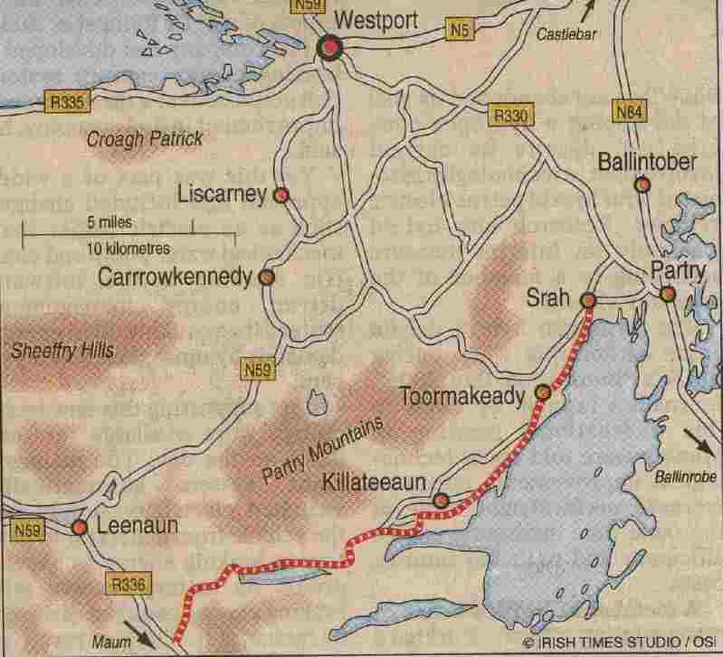
Once again, the area around Leenaun has provided us with another wonderful road. From Leenaun at the eastern tip of Killary Harbour take the R336 signposted for Maum. This is the road that we kicked off the first 'Great Roads' series with last year.
After 7kms take the left turn - signposted with a brown sign for Lough Nafooey. This is the beginning of our drive.
Initially, the road climbs slowly up a valley flanked by the heights of Bunnacunneen to the east and Rinavore to the west. There's the occasional house dotting an increasingly mountainous landscape as the road heads north before turning east.
By now the isolated houses have all but disappeared from the landscape, but cresting a ridge the vista opens out to a very attractive view over Lough Nafooey. Descending towards the western end of the lake the road runs alongside a river cut deep into the mountainside before meeting a tight hairpin and doubling back on itself for a short distance.
Everywhere the surface is good and the road is a pleasure to drive, even in a car with low ground-clearance such as the supercharged Lotus Exige we're driving today.
The road now follows the northern shore of the Lough which has a small sandy shore on its western end. Near the other end of the Lough the road begins to rise above the water, and we take the left road at the junction signposted for Ballinrobe. Now commences a really attractive section of this route with a series of sweeping corners rising all the time. Pause to look back over the valley and Lough Nafooey from one of the several viewing points before leaving this glorious valley - and its road - behind.
The steep cliffs of Cappanacreha and Buckaun now tower over the landscape towards the northwest but our road heads northeast towards the shores of Lough Mask, whose large expanse now spreads before us.
From here the road's character changes as it runs beside the shore passing through the village of Toormakeady and on towards Srah where it turns east once more towards the main Ballinrobe to Castlebar road - the N84, where we finish this exploration at Partry.
Although different in character to the road around Lough Nafooey, this is a satisfying road to drive, often with very good surfaces, and attractive glimpses of Lough Mask along most of its length.
This whole region of Galway and Mayo has relatively few roads on account of its mountainous nature, but the roads that do exist are often through areas of immense grandeur. We left the Lough Nafooey road promising ourselves that we would return to explore this region in detail on a future occasion not too far in the future.
A winding tour of mountains and lakes
In Ireland, roads which traverse mountain ranges are relatively rare. Which is a pity, as where they do occur, they tend to prove to be exceptional journeys, not to mention fine examples of the road-maker's art.
For this journey I travelled along a road new to me which I discovered quite by chance when exploring the road from Leenaun to Delphi, itself a fine road which we'll return to later in this series.
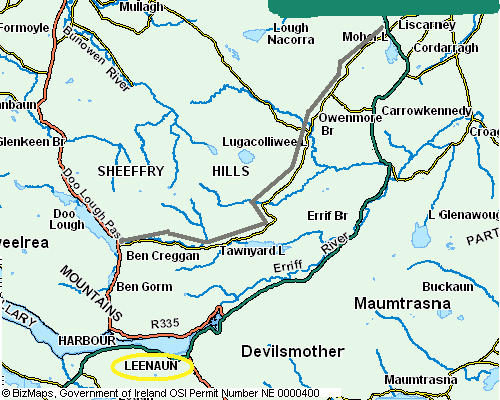
To be truthful, the road from Doo Lough to Drummin does not traverse the mountains; rather it winds its way, at times in spectacular fashion, through a series of valleys between the peaks of Ben Creggan and Ben Gorm on its southern side and the Sheeffry Hills on its northern side.
I began my journey at the signpost for Liscarney on almost the southernmost tip of Doo Lough about two kilometres along the R335 from Delphi travelling towards Louisburg.
This is a spectacular part of County Mayo but at first the road taken does not look promising. Little more than a single vehicle road - although there are plenty of places to pass - it has a good surface all along its length.
But after about a kilometre make sure and pause to look back the direction you have come and you'll see the spectacular bulk of the Teevaree Rocks, part of the Mweelrea Mountains, rise up behind. To the north, running down almost to the road itself, is a spectacular river and waterfall. Clinging to the lower slopes of Ben Creggan (693m) the road winds through a spectacular and wild landscape. Having looked back and seen this spectacular scene, the mood is set for the rest of the journey.
The road now continues in similar vein until after about five kilometres it begins to climb over Tawnyard Lough which presents a complete contrast to the landscape already traveled.
As so often in Ireland, within just a few short kilometres the whole feel of the landscape alters and as the road climbs one finds oneself looking out over a sylvan landscape surrounding the lough and its islands.
The road then begins to travel northeast leaving the lough behind, and as it does so crests a brow to unexpectedly reveal spectacular cliff scenery looking towards Glenlaur to the west.
Here the road clings to the mountain's edge and the signs warning of rock falls are to be heeded - one had evidently happened not long before I made my passage of this portion of the road.
After this spectacular part of the journey the road travels through the tiny village of Drummin which is really the end of our journey. Continue on to get to the main Leenaun to Westport road, the excellent N59, via Owenmore Bridge, then turning east shortly afterwards at the signpost for Carrowkennedy.
As I left this wonderful road and its spectacular mountain passage I was struck again and again by the 'Paul Henry-esque' landscapes which surrounded me on all sides.
Perhaps it was just the day that was in it - a bitterly cold March day with spectacular cloudscapes between the showers of hail - whatever it was, this was a journey that brought me close to the painter's landscapes of the Connemara wilderness.
And that in itself is a good reason to seek out and explore this spectacular road. Enjoy.
Crossing the Mayo Mountains, Doo Lough to Drummin : This drive was described by Bob Montgomery as "Great Roads No2" in the Irish Times, Wednesday, 22/3/06. This is his description: