 A 10 Minute O-tour of Ireland
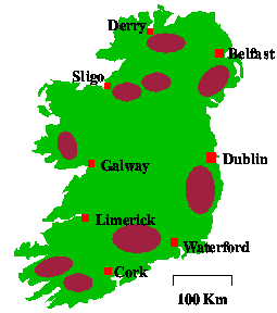
I've knocked together a bit of a map to help explain where everything is.
It's not great but it'll do. The brown regions are the main O areas. They also
correspond quite well to many of the upland areas of Ireland.
In General
Despite having one of the best climates for growing trees, Ireland has one of
the lowest percentage of forested land in Europe (about 7%). Therefore, much
of Irish orienteering is done on open hillside.
Ireland is almost bowl shaped, with most of the upland areas near the coast
and an almost flat, lowland area in the middle. I tend to describe the midlands
as the boring bit you have to drive through to get to the coasts, but this is
a disgraceful generalisation. Much of the east coast is very pretty but most
of the north, west and south coasts are beautiful.
The Tour
We'll start in Dublin for no particular reason.
- Dublin is a city of approx. 1 million people and is the capital
of Ireland. Dublin orienteers do most of their orienteering in county Wicklow
and other areas, but there are several maps in Dublin itself. Many are of parks
like Phoenix park (the largest enclosed park in Europe) and Newbridge
Demesne, but there are also forests in the Dublin Mountains.
- South of Dublin is Wicklow. Most of Wicklow is made up of rounded
granite hills (up to 1000 m high) with extensive areas of plantation forest.
Almost anything that is mapable in Wicklow has been mapped. The whole area is
very scenic.
- I'll pass through the scenic Co. Wexford, as there isn't much orienteering
there, and move on to Waterford. Waterford has a small but active club
that organises events in Wexford, Waterford, Kilkenny and Tipperary. The
brown blob, just west of Waterford, covers the Comeragh, Knockmealdown and
Galty mountain ranges. These are similar to Wicklow but, perhaps, a little
steeper. The Comeraghs also boasts many fine Cwms and Corries.
- On now to Cork. Co. Cork is the largest county in Ireland, and Cork
city is the second largest in Ireland. Orienteeringwise, Cork is made up
of the north and east whare the maps are mainly small steep forests and the
west. West Cork contains some of the best terrain in the country. It is
almost exclusively very complex open moorland. You can find snippets from a
couple of maps from this area in the Shamrock
O-Ringen page.
- Heading north, we reach Kerry, probably the most beautiful county
in Ireland. This contains similar terrain to West Cork, plus the highest
mountains in Ireland.
- Moving north again, we get to Limerick. Once there, we keep going north
to Clare. Clare is not famous for orienteering but it is famous for the
Cliffs Of Moher and the Burren and so is well worth a visit. The Burren is
an almost unique area of bare limestone. Above ground it is home to many rare
flowers, below ground is a huge network of caves.
- North of Clare is Galway. For some reason everybody (including
me) likes Galway City even though it rains there most of the time. Again, Co.
Galway can be split into the east with small flat forests and the west where
the scenery is spectacular. There are only a couple of (very good) maps here
but Galway is worth a visit in any tour of Ireland.
- Heading north again, through the blanket bogs of Mayo, we reach
Sligo. Sligo boasts some of
the almost frightening O terrain in Ireland. It stretches from Union Wood
through Ballygawlay, Killery Mountain and on into Co. Leitrim. There isn't
a self respecting orienteer in Ireland who hasn't been completely lost in
this area at some time.
- At the far North-West of Ireland is our "Undiscovered Country" of
orienteering, Donegal. Donegal has almost everything except people.
It has great scenery, hundreds of beaches, great surfing, great
terrain, but it's so remote that there are very few O maps.
- Heading east, across the border into Northern Ireland, we come to Derry
. There is a very active club based in Limavady that organises good events
in areas such as Binevenagh (used in the 1990 Irish Champs) and Banagher.
- We'll take a short detour, south, into Cos. Fermanagh and Cavan
. These counties boast some good terrain, some great waterways and some
excellent caves.
- Going back to the North-East we reach Antrim. I don't know much
about orienteering here, but the Giant's Causeway, Fair Head and the Glens of
Antrim are sights not to be missed.
- Heading south through Belfast, we reach Co. Down.
Here we find good maps such as Slieve Croob and Slieve Martin. Down also
boasts the Mourne mountains, home of the Mourne Mountain Marathon, some
bleak but beautiful scenery and some good climbing crags. I hope to add
a Mourne Mountain Marathon page later in the year.
- Back across the border to Co. Louth. Most orienteering here is in
the Cooley mountains and the best map is of Carlingford mountain. This was
first used for the Irish Champs in 1993.
- That about gets us back to Dublin and the end of the tour
I hope you've enjoyed this tour. There are 32 counties and I've only
mentioned 19 of them. That doesn't mean that there is no orienteering in them
or that they are totally uninteresting. In fact, two of my favourite maps,
Mullaghmeen and the Curragh are in counties not on the tour.
If there's anything that you'd like added, changed or omitted then please
let me know.
