![]()
ATC & Meteorological Services
![]()
Weather Forecast
|
|
|
ATC & Meteorological Services |
|
|
|
Weather Forecast |
|
24 hour Air Traffic Services |
|
Navigation and landing aids include: |
|
VOR |
DME |
|
ILS Category II |
Radar (SSR) |
|
Primary Surveillance Radar |
Monopulse Secondary Surveillance |
|
NDB's |
|
Two NDB based IFR holding Patterns are available. |
|
Approaches |
|
ILS Category II to Runway 24 |
VOR/DME to Runway 24 |
|
ILS/DME to Runway 06 |
VOR/DME to Runway 06 |
| The Shannon Air Traffic Control Centre has established procedures whereby westbound aircraft departing Shannon have equal access to optimum flight and route levels as overflying traffic. | ||
| Extensive radar coverage to the west facilitates aircraft climbing to optimum flight levels and tracks. | ||
|
Air Traffic Routes and Navigation Services |
| The principal traffic area on the North Atlantic is along or close to the Great Circle Track between Shannon and New York. 60% of all North Atlantic traffic passes through the Shannon UAC area. Technical landings at Shannon for such traffic involve minimum overall added distance. | ||
|
Meteorological Services |
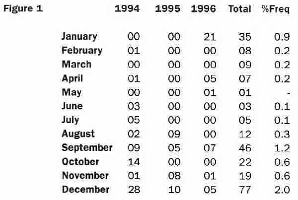
| Shannon Airport is generally favoured with good flying weather. Figure 1 (below) shows the number of hourly occurrences of horizontal visibility less than 400 metres during the five year period, 1992-1996. Percentage frequency of the total for each month is also give. The incidence of snow at Shannon is negligible. The number of days on which snow of depth 1 cm or more was reported at Shannon in the same five year period was two. the greatest depth in the period was 6 cm. |
| - Forecasting and observing staff are on duty throughout the 24 hours. | ||
| - Meteorological services, in accordance with ICAO procedures, is provided for long and short range flights. | ||
| - Shannon Airport is the location of the Central Aviation Office providing meteorological services for all aerodromes in Ireland. | ||
| - The office is connected to the Meteorological Operational Telecommunications Network Europe (MOTNE) which provides operational meteorological information (OPMET) for the European Region. It also has access to European and Washington data banks which provide OPMET information on a world wide basis. | ||
| - A link with the European Meteorological Telecommunications Network (EMTN) provides basic information for chart purposes. | ||
| - World Area Forecast System (WAFS) charts are received by landline facsimile from the Regional Area Forecast Centre in Bracknell, U.K. Other charts are received from the European Centre for Medium Range Weather Forecasting (ECMWF) in Reading, U.K. | ||
| - A 10 cm digitised weather surveillance radar is sited at the Airport. | ||
| - Weather satellite reception of geostationary satellites is also available. |
|
|
|
|