
|
||||
|
|
|
Inis Oírr (also spelt Inis Thiar, Inishere and Inisheer) means Eastern Island. Its five villages are clustered close together and are situated on one side of the island. They are called West Village (around the pier), Lurgan village (TEAS), Chapel Village, Castle Village and Formna Village. The island measures two and a half by one and a half square miles. It has a population of 304 people (532 in 1891), and Irish is the daily language of the islanders.
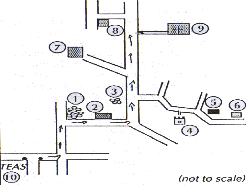
1. Cnoc
Raithni (Hill of Ferns)
After you've enjoyed your tea and scones
at TEAS, turn right at the gate and then left. Ahead you will see a circular
mound with two vertical stones in the centre. This is called Cnoc Raithni.
During the great storm of 1885 sand was blown away from the Hill and a
very important archeological site was revealed. The mound that remained
comprised a two-tier cemetery. The lower level dates from the Early Bronze
age (c. 1600 - 1400 BC) and the upper level from the early Christian period.
A bronze pin was discovered close to the site, but the more interesting
finds were two burial urns, which covered cremated human remains. The urns
are now in the Nationnl Museum in Dublin.
As you continue on your tour your eyes
are naturally drawn to O'Brien's Castle. You will notice that Castle Village
is situated on a terrace. Millions of years ago the three Aran islands
were joined to the north western corner of Clare. The terraces in Inis
Oirr can be matched geologically with the terraces of the Burren. As in
the Burren, the limestone rock lies in vast layers. The stone is easily
split and levered from the layers and all the old cottages (including TEAS)
were built from the stone of the island. Nowadays most houses are built
with imported blocks.
2. Camping
Site
On your left you pass the Camping Site
and public toilets. This was built by the island cooperative in 1987. The
island co-op was started in 1971 by some islanders who wanted to improve
the facilities on the island. There is a manager and four people who work
full-time and a committee of 12 islanders who oversee the work of the co-op.
3. Ruins
of Saint PauI's Church
There is nothing now but a few stones
marking the site of a church dedicated to Saint Paul. Today every funeral
stops and rests here on the road for a few moments of silent prayer. The
pause seems strange to visitors who are not aware of the tradition. The
church was known to have existed as late as 1685.
4. O'Brien's
Castle
Fram the rond you cnn see O'Brien's Castle.
It was built by the descendants of Brien Boru, the High King of Ireland,
who defeated the Danes in Clontarf in 1014. The castle was built in the
late l4th century, within the existing fort of Dun Formna. This fort was
built a thousand years before O'Brien's Castle. The Castle originally had
three storeys. The ground floor has three apartments; the two upper floors
were of timber and no longer exist. The south-east corner was destroyed
by the Cromwellians in the mid l6th century. The O'Briens ruled the islands
from the end of the l3th century. They protected Galway Bay from pirates
and for this service the merchants of Galway paid them anannual tribute
of twelve "Tuns" of wine. A tun was 252 gallons. The O'Flahertys of Connaught
defeated the O'Briens in 1565. The O'Briens then appealed to Queen Elizabeth
I of England. She expelled both the O'Flahertys and the O'Briens from Aran
and took over the islands herself on the basis that Ararn was church property
and so belonged to neither of the families. (Aran has been a monastic settlement
for 500 years since the arrival of Saint Enda in 483 AD). She granted the
islands to an Englishman on condition he maintain a force here.
5. Signal
Tower
Behind O'Brien's Castle is the Signal
Tower. It was built by the British in the time of Napoleon, when they feared
an attack by the French. After Waterloo (1815) it was no longer needed
and fell
6. Ruins
of Old School
Behind the Signal Tower are the ruins
of the school that lasted from 1889 - 1942. At the end of the l9th century
the British government wanted a school to be built on the island. The landlord
did not want the children to receive an education and refused to give any
land. However a law was passed in London forcing him to donate Iand for
a school. In revenge he gave a plot of land on the highest point of the
island, forcing the Iittle children to make two long climbs every day.
7. Scoil
Caomhán
On your Ieft, before the airstrip, you
pass the national school named after the patron saint of the island. This
school was opened on 4th February 1942. There are at present 44 pupils
and two teachers, one teaches from infants up to second class and the principal
teaches third class up to seventh.
8. Aer
Árann
Behind the school lies the airstrip. In
1971 Aer Arann came to Inis Mór and two years later to Inis Meain
and Inis Oirr. Thereare three flights daily to the island, in the morning
and the evening. The plane usually only operates during daylight, so in
the winter the second flight is in the early afternoon. At Christmas, Easter
and holiday times there are many more flights. The plane flies to Inverin
in Connemara and a minibus takes the passengers on to Galway. The plane
flies in most weather except fog.
9. Saint
Caomhán's Church
Leave the road and turn right and head
up a steep sandy incline towards the cemetery. The great mass of shells
underfoot is the remains of an early Christian or medieval kitchen midden.
The graveyard itself is a large sand-dune with layer upon layer of burials
to a depth of 20 feet or so. Saint Caomhán, a disciple of Saint
Enda, is the patron saint of the island. His feast day is l4th June and
Mass is celebrated on that day in the church. The church dates from the
l0th century; its structure has been much altered through the ages. Next
to the church Iies the grave of Saint Caomhán. This is known as
the Bed of Caomhán. In recent years a structure was erected over
the Bed to prevent it being buried under the sand. People believe that
if they lie on the Bed they will be cured of illnesses, especially on the
vigil of the Saint's feast.
This is the end of the tour. You can however
continue past the airstrip and the Formna village towards the Iake. Further
on you can see the wreck of the freighter "Plassy", which was wrecked on
8th March 1960 on the Carraig na Finnise reef. All the crew were saved
by the islanders. Heavy seas later moved it up to where it is now resting.
10. TEAS
Or you can return to TEAS for a slice
of homemade apple tart and whipped cream and a refreshing cup of tea or
coffee.