
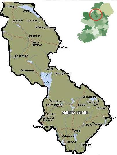
"Tourism in Leitrim" |
Click on the region that you wish to find out more about:
South Leitrim is an area of lough's and rivers, the greatest of which, the mighty River Shannon,
flows along the region's western boundary. It is a fisherman's paradise, but a rambler's haven too.
Rising above the waters is a series of small hills, or drumlins, and there is a large area of flatland
peppered with historic ruins and grand houses.
Carrick on Shannon
Leitrim Village
Drumsna
Jamestown
Back to the Map
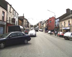
Carrick on Shannon/Cora Druma Rúisc
 The "weir of the marshy ridge", with a population of 2,500, is the smallest county town in Ireland,
and its inhabitants are well outnumbered by the local cormorants and swans.
For centuries it was merely a crossing point on the River Shannon, but in the early 17th century
it was fortified and garrisoned to protect the new settlers.
The "weir of the marshy ridge", with a population of 2,500, is the smallest county town in Ireland,
and its inhabitants are well outnumbered by the local cormorants and swans.
For centuries it was merely a crossing point on the River Shannon, but in the early 17th century
it was fortified and garrisoned to protect the new settlers.
Carrick's lock and waterworks date from the early 1800's, and it was a bustling centre
in the early 19th century when water transport was vital and when recurring famines meant
cheap labour. Today it is a popular centre for Shannon cruising.
To go boating not more than a mile from the town is to explore an unspoilt and tranquil wilderness:
the river glides past ghostly castles, ravaged stone crosses and deserted hamlets.
Boats can be rented from the town, for days or weeks at a time.
 At the junction of Bridge and main Streets is Irelands smallest church, the Costello Memorial Chapel, which measures only 16ft long, 12ft wide and 30ft in height. The chapel was built in 1877 by Edward Costello, a wealthy merchant, as a memorial and burial vault for his wife Josephine. The interior is lined with yellow Bath stone. On both sides of the ornately tiled aisle is a sunken space, each of which holds a coffin lined with lead and covered with slabs of thick reinforced glass. The remains of both Edward and Josephine lie in them.
Back to the Map
Leitrim/Liatroim
This quaint little village gave its name "grey hil" to the county, a reflection of its past importance to
the county as a major stronghold of the O'Rourke cheiftains. Their castle in the village was captured
by the British in 1603 at the end of the Nine Years War, and as a result, only part of the castle remains intact.
With the old vllage pump still stending under a spreading chesnut tree, Leitrim seems to have been left in the
19th century, except for the Ballinamore-Ballyconnell canal, which joins the Shannon here.
Their meeting point can be seen from the bridge. Leitrim is surrounded by rivers, canals and woodland,
making a great place for the tourist looking for some peace and quiet.
Drumsna/Droim ar Snámh
The often lazy, lordly Shannon hurries with suddenly unaccustomed vigour through Drumsna,
as if anxious to reach the sea. Visitors should avoid making the same mistake, if only to
take in reminders of the celebrities who lived in the village overlooked from the north by Slieve Anierin.
Novelist Anthony Trollope, then a senior civil servant, was sent here in 1843 to investigate
the affairs of the postmaster who "had come to some sorrow" over his money. While he was there
he wrote his first novel The McDermotts of Ballycloran, published in 1847.
A plaque marks the house where he stayed, now the village pub.
Adjoining the churchyard are the remains of a preaching house founded by John Wesley.
The brothers George and William Strawbridge were worshippers there and later were to travel
to North America, in 1760, where they helped to establish Methodism, with a following today of 20 million.
Back to the Map
Jamestown/Cill Srianáin
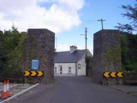 At Jamestown the River Shannon pauses in its 215 mile journey to the sea and sweeps back on itself to
run north for 100yds or so. Sir Charles Coote founded the town in 1625 to safegaurd the Shannon crossing
and named it after James 1. Despite the fortifications, the town was occupied by the O'Rourkes,
a powerful local clan, in 1642. Only the lower part of one gateway survives as a memento of the
17th century town wall, spanning the old Dublin-Sligo road.
At Jamestown the River Shannon pauses in its 215 mile journey to the sea and sweeps back on itself to
run north for 100yds or so. Sir Charles Coote founded the town in 1625 to safegaurd the Shannon crossing
and named it after James 1. Despite the fortifications, the town was occupied by the O'Rourkes,
a powerful local clan, in 1642. Only the lower part of one gateway survives as a memento of the
17th century town wall, spanning the old Dublin-Sligo road.
Today, Georgian houses line Jamestown's wooded river banks. Towards the river, from the Jamestown
Arch, the last remains of the O'Rourkes Castle can be seen.
Back to the Map
The spectacular Lough allen, the historic Shannon an a score of other waterways embroider this
patchwork of land, cutting through mountains and accross meadows where it is possible to wander
for miles without encountering another person. It is ideal country for messing about in boats,
biking up a mountain, walking in the glens or simply admiring the scenery.
Ballinagleragh
Drumkeeran
Drumsahmbo
Keshcarrigan
Ballinagleragh
Dowra
Back to the Map
Drumkeeran/Droim Caorthainn
The spectacular road to Drumkeeran, "the ridge of the quicken tree", skirts
the winding shores of Lough Allen. Boat trips are run to the 6acre island of
Inishmagrath, on which lie the ruins of an ancient and disused graveyard.
The island lies about 400yds from the Lough shore and, for centuries,
people in the district buried there dead there. In bad weather,
when crossings were impossible mourners would gather at Dead Mans Point
on the mainland and keep watch over the dead until the weather had subsided.
Back to the Map
Drumshanbo/Droim Seanbhó
Drumshambo, at the south of Lough Allen, gives access to some of the best scenery in Ireland.
Bordering the Lough, to the northwest; are the Arigna mountains, and to the northeast Slieve Anierin
(the mountain of Iron), one of a range of heather-clad mountains pierced by steep-sided valleys that
echo to the cries of grouse, pheasant, wild duck and a host of other wildlife. The Lough Allen Scenic
Tour starts and finishes its 30 mile circuit of the lake, which is 8 miles long and 3 miles wide, in the town.
The name Drumshanbo comes from "the ridge of old huts", a somewhat unromantic name for what has become
a beautiful town, and a favorite hideaway for honeymooners. An excelent audio visual show at the Slieve
Aneirin Visitor Centre tell the story of a bygone time in the area, of life on the Ballinamore-Ballyconnell
Canal (recently redeveloped), iron and coal mining, and of the railway and lakes nearby.
Drumshanbo is also host to the oldest festival n Leitrim, the famous An Tostal,
a week long Festival of Traditional Irish music, song and dance. In happens in early July.
Outside the town itself, at Barnameenagh, is the stone of the legendary Fionn MacCool, whic legend has
, he hurled at his enemies from the Arigna side of Lough Allen to near the top of Slieve Aneirin.
You can see indentations on the rock where it is said Fionn gripped it, and it is said that by
placing your fingers in these holes, you will be rewarded with the gift of stamina, useful indeed
if you intend to walk or cycle around the nearby hills. If the ancient tales are to be believed,
Fionn's warriors, the Fianna, are said to be lying asleep in the mountainbs, awaiting his next call to battle.
Lough Allen and the surrounding lakes and rivers are one of the major coarse anglling and fly-fishing
centres of Europe.The lakes are constantly re-stocked with trout, so don't worry that you'll catch them all.
North of Drumshanbo is the Poor Clare Convent where nuns kneeling in pairs, offer continuous Adoration
of the Blessed Sacrement, day and night. Pilgrims travel the world to come here to join in the prayer.
Back to the Map
Ballinagleragh/Baile na gCléireach
In the northeast corner of Lough Allen is "the peaceful angling town of the clergy" because it
has been the birthplace of so many clerics. Among them was the local legend Father Charles "Racey"
Reynolds, who lived in Ballinagleragh in the late 18th century. A great sprinter,
he is said to have been chased by pursuers for 7 miles before leaping over a chasm
called Poll an Chait. He said of this feat: "Ah sure, I had a good run at it…seven miles or so."
Back to the Map
Mohill
Fenagh
Carrigallen
Ballinamore
Newtowngore
Cloone
Back to the Map
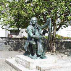
Mohill/Maothail
 Streets that weave in and out of each other with a bar or quaint shops around almost every corner make
Mohil an appealing place to wander around. Commanding the town centre is a life-size bronze
bust of the blind harpist Turlough O'Carolan (1670-1738).
Streets that weave in and out of each other with a bar or quaint shops around almost every corner make
Mohil an appealing place to wander around. Commanding the town centre is a life-size bronze
bust of the blind harpist Turlough O'Carolan (1670-1738).
Nearby is lough Rynn House, one of the homes of the Earls of Leitrim. The mansion, built in 1832,
has been fully restored to its original glory and the grounds are being constantly upgraded and
will soon become one of the major gardens of Europe. William Sydney Clements, 3rd Earl of Leitrim,
was one of Leitrim's most notorious characters. He was eventually ambushed and assassinated in 1878
and after his death was accused in the House of Commons of exercising the droit de seigneir
the right to sleep with a bride on her wedding night before her husband did!
 The estate covers more than 100 acres of woodland, ornamental gardens and open pasture.
There are also 600 acres of lakes, and a lakeside turret house with memorable views of the countryside.
The terraced walled garden, dates from 1859 and covers 3 acres. The arboretum contains many exotic trees,
including tulip trees, Californian redwoods and the oldest monkey puzzle (Araucaria)tree in Ireland.
The estate covers more than 100 acres of woodland, ornamental gardens and open pasture.
There are also 600 acres of lakes, and a lakeside turret house with memorable views of the countryside.
The terraced walled garden, dates from 1859 and covers 3 acres. The arboretum contains many exotic trees,
including tulip trees, Californian redwoods and the oldest monkey puzzle (Araucaria)tree in Ireland.
Picnic sites with supervised play areas have been laid out near the old sawmill that once generated much of
the estate's income. Nature trails are signposted and lea to various sites offering views across the lakes
and countryside. One of the lakes has a 4000-yesr-old artificial island, or crannog.
And on a hill within the grounds is a druidic altar on which human sacrifices were offered.
Mohill lies in the heart of Leitrim's lakeland at the head of Rinn lough, surrounded by the low-backed
drumlin hills. The lakes abound with coarse fish, and a match stretch has been laid out on the lakes
for the international fishing competitions.
Lough Rynn House And Gardens.
May/Sept, daily 11am-7pm. Tel (078) 31427.
Back to the Map
Fenagh
All that remains of the site of the monastery founded by St Caillín are the ruins of two old churches.
The southern church has a 14th century doorway, while the northern one which was built in the 15th
century has dressed stones from the pre-Norman era. You can also see the remains of the paths between
the monks cells in nearby feilds. The Book Of Fenagh , completed at that monastery in 1516
contains a list of all the lands and privilages of the monastery as well as a collection of "wonders"
alleged to have been performed by St. Caillín. It can now be viewed in the Royal Irish Academy in Dublin.
On the Mohil road, outside of Fenagh, a Giants Grave, a Stone Age two-court cairn can be viewed.
Furture on the same road is a ballroom that once held the biggest bands from around throughout the 1950's.
Sadly its now in ruins as the money gained was spent in two other ventures,
a wall of death (for motorcycles) and an unheated swimming pool.
Back to the Map
Carrigallen
Ballinamore/Béal an Átha Móir
Many Loughs and several miles of river lie within easy reach of Ballinamore, making it an ideal touring centre.
And the many low-backed ridges, called drumlins, that dot this landscape also attract ramblers.
But the village has its own places of interest, including the Leitrim Heritage Centre which deals
with enquires from people who wish to trace ancestors that came from Leitrim.
Ballinamore was the first town in Ireland to provide this service and now answers quires from all around the world,
tracing relatives through registers dating from the early 1800's.
The Heritage Centre shares the same building as the town library and the museum.
In its collection is the shirt collar worn by the patriot Sean MacDiarmuid,
when he was executed in 1916 for his part in the Easter Rising.
Other museum exhibits include old farming and kitchen implements.
Leitrim Heritage Centre Mon-Fri 10am-1pm, 2pm-5pm.
Museum Mon, Wed, Thur 9.30am-5pm; Tues, Fri 9:30am-8pm.
Back to the Map
Once, the glen of this land of battles echoed to the sound of the cries of warriors,
and it was here that the abduction of the "Helen" of Ireland brought about the Anglo-Norman
invasion that devestated the Ancient Kingdoms. Now the valleys are disturbed by little more
then the sounds of wildlife and the rustle of trees, and the only fierce battles these days
are fought between the fishermen and salmon or pike.
Manorhamilton
Glenfarne
Drumahaire
Back to the Map
Manorhamilton/Cluainín
Four mountain valleys sweep down to Manorhamilton which sits on plain, or "little feild"
as the name means in Irish.Many of the surrounding peaks rise to near 1500ft so you can
find alpine plants, such as saxifrage and mountain avens growing near the top.
The town itself was founded b Sir Frederick Hamilton, one of the many Hamiltons to come
over to Ireland from Scotland. He was granted 5000 acres of pastureland and 10,000 acres
of woodland by Charles I in 1630. You can still see the ivy coloured remains of Sir Fredericks castle,
a great example of a 17th century baronial mansion.
The town is a base for some brilliant scenic walks and is nearby to the sea and five other countries.
The famous Wild Rose Festival is held in the town every August at which the Wild Rose Colleen is chosen.
The festival is in comemeration of the romance between Caitlin Ní Cuirnin, the wild rose of Lough Gill,
and Edmund Tracey, foster son of Owen O'Rourke, chieftain of Dromahair
in the 1960sCandidates for the title are chosen from throughout Ireland, and also from
London and Madrid, places where Caitlin is said to have traveled. The prize is a piece of
handcrafted Irish Crystal.
Back to the Map
Glenfarne
Drumahair/Droim dhá Thair
Kinlough
Askill
Kiltyclougher
Back to the Map
Kinlough
Askill
Kiltyclougher
Back to Main Page
|
|---|