TRANSLATE
THIS PAGE AUTOMATICALLY BY COMPUTER
|
||
| Home |
TRANSLATE
THIS PAGE AUTOMATICALLY BY COMPUTER
|
||
| Home |
|
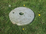 QUERN STONE FOUND NEAR GRANGE: The item
of cut-stone on the right was found some time ago within a short distance of the ruined
building at Grange (shown above). It is believed that it belonged to the monks who once
lived there. For the reasons given above the monks at Grange probably left in a great
hurry: taking with them only their lighter and more valuable possessions. This stone is
thought to be part of a hand-mill for grinding cereals of the kind used in bread making.
In olden times it would have been called a quern. Monks of the
time would normally be fully self-sufficient as far as the provision of food for their
communities was concerned. The local person who found the stone expressed the thought that
local school children might enjoy (and benefit) from seeing it, and consequently it is at
present (May 2000) on display in one of Finnerty's shop windows. The wish has also been
expressed that at some later date this stone might be returned to the area
where it was found, possibly as part of a small, simple monument in memory
of the community of monks who once lived and worked at Grange. The newly formed New
Inn Local Community Council has been informed, and it is hoped that its
members will give some thought to this idea. The person who found the stone would prefer
to remain anonymous. QUERN STONE FOUND NEAR GRANGE: The item
of cut-stone on the right was found some time ago within a short distance of the ruined
building at Grange (shown above). It is believed that it belonged to the monks who once
lived there. For the reasons given above the monks at Grange probably left in a great
hurry: taking with them only their lighter and more valuable possessions. This stone is
thought to be part of a hand-mill for grinding cereals of the kind used in bread making.
In olden times it would have been called a quern. Monks of the
time would normally be fully self-sufficient as far as the provision of food for their
communities was concerned. The local person who found the stone expressed the thought that
local school children might enjoy (and benefit) from seeing it, and consequently it is at
present (May 2000) on display in one of Finnerty's shop windows. The wish has also been
expressed that at some later date this stone might be returned to the area
where it was found, possibly as part of a small, simple monument in memory
of the community of monks who once lived and worked at Grange. The newly formed New
Inn Local Community Council has been informed, and it is hoped that its
members will give some thought to this idea. The person who found the stone would prefer
to remain anonymous. |
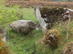 PORTAL TOMB?: Less than a mile from
Grange, the stones shown on the left can be seen at a place called Cloonbenes. This
place-name is thought to be derived from the Celtic words cluain
binneas - literally "meadow sweet", but meaning
"sweet meadow". They are just inside a gate by the roadside. It is
thought that this collection of stones might be the collapsed
remains of a portal tomb. Portal tombs are now believed to be
above-ground burial chambers for the remains of people cremated in very ancient times.
They normally consist of 3 to 7 upright stones which support one (or sometimes two) really
heavy capstones. These monuments are also referred to as dolmens - a
word which has evolved from the two Old Breton Celtic words "tol mén":
which literally mean "table of stone". Some believe that dolmens were also used
as alters by the Celtic druids of long ago. Several of the portal tombs examined
scientifically are now believed to be in the region of 5,000 years old. PORTAL TOMB?: Less than a mile from
Grange, the stones shown on the left can be seen at a place called Cloonbenes. This
place-name is thought to be derived from the Celtic words cluain
binneas - literally "meadow sweet", but meaning
"sweet meadow". They are just inside a gate by the roadside. It is
thought that this collection of stones might be the collapsed
remains of a portal tomb. Portal tombs are now believed to be
above-ground burial chambers for the remains of people cremated in very ancient times.
They normally consist of 3 to 7 upright stones which support one (or sometimes two) really
heavy capstones. These monuments are also referred to as dolmens - a
word which has evolved from the two Old Breton Celtic words "tol mén":
which literally mean "table of stone". Some believe that dolmens were also used
as alters by the Celtic druids of long ago. Several of the portal tombs examined
scientifically are now believed to be in the region of 5,000 years old. |
 CAIRN: The stones shown on the
right, which are just by the roadside, are located 5 miles or so to the north
east of New Inn village near a place called Alloon
(which is close to Ballymacward). As there is a fairly large
river in the area, Alloon is probably a corruption of the Celtic words Áth Lúain, meaning Luan's Ford. Some may
be interested to know that a slightly different corruption of the same two words has
produced the much better known Irish place-name Athlone. The stones in this
photograph form a very small part of what is called a court cairn.
Some archaeologists believe that court cairns may be the very oldest form of Irish burial
monument. CAIRN: The stones shown on the
right, which are just by the roadside, are located 5 miles or so to the north
east of New Inn village near a place called Alloon
(which is close to Ballymacward). As there is a fairly large
river in the area, Alloon is probably a corruption of the Celtic words Áth Lúain, meaning Luan's Ford. Some may
be interested to know that a slightly different corruption of the same two words has
produced the much better known Irish place-name Athlone. The stones in this
photograph form a very small part of what is called a court cairn.
Some archaeologists believe that court cairns may be the very oldest form of Irish burial
monument.
Radiocarbon tests (believed to be accurate to within a few hundred years) indicate that one such cairn at Ballymacdermot (Co. Armagh, in Northern Ireland), was constructed in 4975 B.C., making it somewhere in the region of 6,975 years old. This would mean that structures of this kind were being built in parts of Ireland (including Alloon?) well over 2,000 years before the first of the great pyramids of Egypt was constructed. The Pyramid Age, Dynasties III to VI, during which all of the really spectacular pyramids in Egypt are believed to have been built, was between 2686 B.C. and 2181 B.C.. In so far as we know, and as seems to be the case with dozens of other ancient monuments in the local area, there has never been any significant archaeological study of the cairn near Alloon. For those who are interested in seeing it, its exact location is shown on current editions of Map 46 in the Discovery Series of the Ordnance Survey of Ireland (which is compiled, published and printed by The Ordnance Survey Office, Phoenix Park, Dublin). Many of the larger newsagents in the Republic of Ireland stock copies of this particular series of maps. The Cairn at Alloon is listed under the name "Annagh an Teanach" (reference number 1026) on pages 4 and 5 of the book entitled "Archaeological Inventory of County Galway (Volume II)" - which was published in 1999 by the Government Stationary Office in Molesworth Street, Dublin 2. It is referred to using the word "Tumulus": suggesting that it is very old - possibly from the Neolithic period. Unfortunately, the part shown above on the right has been badly damaged, and this Government publication contains the following statement: " ... the SW half was completely removed in 1977 during road widening". |
Turoe Stone | Top of this page | Corruption of Irish names
More about Irish archaeological sites
VISITOR |
NUMBER |
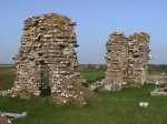 RUINS AT GRANGE (New Inn): The
two parts of the building shown on the left are all that remain (above ground at least) of
the monastery which is thought to have been inhabited by Cistercian monks several
centuries ago. The Cistercians were introduced to Ireland by St. Malachy - with the help
of St. Bernard at Clairvaux in France (where St. Malachy used to stay on his way to and
from Rome). The first Cistercian settlement began in Ireland in 1142 at Mellifont (near
Droheda). Between 1538 and 1542 many sites like those at
Grange were looted and damaged by soldiers who took their instructions from King Henry
VIII of England: a man who appears to have had few qualms about physical violence, and who
had Anne Boleyn (his own wife) beheaded. Sometime during this 4 year period, it is thought
that the monks at Grange may have suddenly fled in fear for their lives to nearby
Derrynamanagh. The place-name Derrynamanagh is in all probability a corruption of
the Celtic words Doire na Manach,
meaning The Wood of the Monks. It is noted in at least one reference book that
the Cistercian monks did have a liking for lonely wooded places. Parts of the village of
New Inn can be seen in the background between the two stone columns above. Several members
of the local Finnerty family are buried close to the ruins in the photograph above,
including the oldest known member to have lived in the New Inn area; he was Michael
Finnerty, who was born in 1796 and died in 1870. (For information on the older parts of
Grange, please click
RUINS AT GRANGE (New Inn): The
two parts of the building shown on the left are all that remain (above ground at least) of
the monastery which is thought to have been inhabited by Cistercian monks several
centuries ago. The Cistercians were introduced to Ireland by St. Malachy - with the help
of St. Bernard at Clairvaux in France (where St. Malachy used to stay on his way to and
from Rome). The first Cistercian settlement began in Ireland in 1142 at Mellifont (near
Droheda). Between 1538 and 1542 many sites like those at
Grange were looted and damaged by soldiers who took their instructions from King Henry
VIII of England: a man who appears to have had few qualms about physical violence, and who
had Anne Boleyn (his own wife) beheaded. Sometime during this 4 year period, it is thought
that the monks at Grange may have suddenly fled in fear for their lives to nearby
Derrynamanagh. The place-name Derrynamanagh is in all probability a corruption of
the Celtic words Doire na Manach,
meaning The Wood of the Monks. It is noted in at least one reference book that
the Cistercian monks did have a liking for lonely wooded places. Parts of the village of
New Inn can be seen in the background between the two stone columns above. Several members
of the local Finnerty family are buried close to the ruins in the photograph above,
including the oldest known member to have lived in the New Inn area; he was Michael
Finnerty, who was born in 1796 and died in 1870. (For information on the older parts of
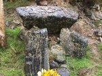
Grange, please click 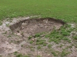 One hundred yards or so behind the mound with the stones shown immediately
above, there is a piece of ground (approximately 12 feet in diameter) which appears to
have sunk down to varying depths of between 1 to 3 feet roughly (please see photograph on
left). When it rains heavily this depression takes in a flow of water (similar to a
drain). This might indicate the presence of a partly collapsed subsidiary chamber
of the kind often associated with court cairns. If there is a partly collapsed subsidiary
chamber underneath, it may be linked underground to the main cairn mound, and it may be
just one of a number of subsidiary chambers.
One hundred yards or so behind the mound with the stones shown immediately
above, there is a piece of ground (approximately 12 feet in diameter) which appears to
have sunk down to varying depths of between 1 to 3 feet roughly (please see photograph on
left). When it rains heavily this depression takes in a flow of water (similar to a
drain). This might indicate the presence of a partly collapsed subsidiary chamber
of the kind often associated with court cairns. If there is a partly collapsed subsidiary
chamber underneath, it may be linked underground to the main cairn mound, and it may be
just one of a number of subsidiary chambers.