|
|
|
|
|
|
|
|
|
 .
.

The patterns of settlement in Early Christian County Down
|
|
|
|
|
|
|
|
|
The patterns of settlement in Early Christian County Down
The question of where Early Christian people lived and why is fundamental to understanding their society. Of all the factors which influenced settlement in the past, the physical environment must have been one of the most important and there are three main factors which should be considered when examining settlement sites in relation to their surrounding landscape:
To analyse the effects of these elements on the Early Christian settlement of County Down a GIS package, SPANS, was employed to overlay the archaeological sites on base maps illustrating these environmental factors.
Early Christian sites in County Down.
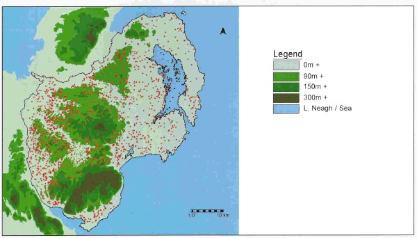
Classifying the Early Christian Settlements in County Down. The sites in this study were classified using information from the Sites and Monuments Record compiled by the Environment and Heritage Service (Department of the Environment, N.I.). There is a total of 2800 sites recorded for County Down and from these the probable Early Christian sites were placed into a total of eighteen categories, shown in the table below.
Classified Early Christian sites in County Down
|
Thesis code |
Site Type |
Total number of sites |
|
1 |
Rath |
1121 |
|
2 |
Probable rath |
53 |
|
3 |
Platform rath |
37 |
|
4 |
Raised rath |
15 |
|
5 |
Rath and souterrain |
13 |
|
6 |
Large rath |
6 |
|
7 |
Conjoined raths |
2 |
|
8 |
Rath pairs |
10 |
|
9 |
Bivallate rath |
19 |
|
10 |
Trivallate rath |
6 |
|
11 |
Large enclosure |
33 |
|
12 |
Cashel |
62 |
|
13 |
Crannog |
46 |
|
14 |
Mound |
11 |
|
15 |
Souterrain |
57 |
|
16 |
Ecclesiastical site: Pre-Viking |
16 |
|
17 |
Ecclesiastical site: Pre-Norman |
17 |
|
18 |
Ecclesiastical Site: Probably Pre-Norman |
12 |
A few of these categories require some explanation:
Large raths
Proudfoot (1970, 37) has described these sites as 'larger and more complex than the usual rath yet not as large or obvious as hillforts'. It is uncertain what particular function, if any, these sites performed, although they may be similar to the 'Cluster Four' sites identified by Stout (1991, 218).
Large enclosures
These are earthen enclosures with a bank and ditch, measuring over fifty metres in diameter, and which have not been identified by the SMR as large raths. The term 'large enclosure' represents a varied group of sites and their location ranges from hilltops to lower valley slopes. Davies (1947, 10) suggests that the majority may be cattle enclosures of the Early Christian period. Whatever their function, these sites form a distinct class of unusual enclosures and have been defined as a separate class so that their location may be compared with that of the other site types.
Ecclesiastical sites
This study followed the classification of ecclesiastical sites as used by Hamlin (1976) which is based on dating evidence rather than episcopal / monastic divisions.
Excluded site types
Several site types were excluded from this study due to the very small number definitely identified, or because they were associated with other sites which are already included in the list. This category includes hill forts (2), field systems (2) and horizontal mills (3).
Environmental basemaps
Four maps which encompassed the environmental factors were used as basemaps: unfortunately due to the expense involved the digital versions of these maps could not be purchased from the Ordnance Survey (NI) but had to be manually digitised.
Contours
The contours were digitised from the 1:63,360 scale third edition series maps of Ireland, sheets 313, 314, 320, 321 and 327, published by the War Office in 1942.
General Soil map
The General Soil Map of Ireland (first edition, 1969) was compiled and published by the National Soil Survey, Soil Division, An Foras Talúntais.
Land Classification map
The Land Classification Map of Northern Ireland was prepared by the Land Utilisation Survey of Northern Ireland, and was published at a 1:375,000 scale by the University of London Press in 1963. This map provides information on how land is classified today and without the modern chemical fertilisers or heavy agricultural machinery an Early Christian farmer may not have regarded the land in quite the same light. However, the Soil map does not necessarily always show us the full picture, i.e., two areas consisting of the same soil type may in fact be of different quality, depending on slope, drainage, aspect, etc. This Land Classification map can therefore be used in conjunction with the Soil map to give us a more rounded picture of the potential of the land within County Down.
CORINE Land Cover maps
CORINE stands for the Co-ordination of Information on the Environment. This was a project carried out between 1985 and 1990 by the European Environment Agency and the maps were created using satellite images. Forty-four classifications are used, although this has been simplified for use in this study and the smallest areas are twenty-five hectares - much more detailed than the other soil and landuse maps.
By using these three sources of information on land potential, combined with the contour map, it was possible to build up a comprehensive view of the relationship between settlement patterns and the physical environment in County Down.
Unfortunately, due to the limitations on the number of colours and symbols available for display within the GIS package the site types had to be divided into two groups and displayed on two separate copies of each basemap.
The physical environment of County Down
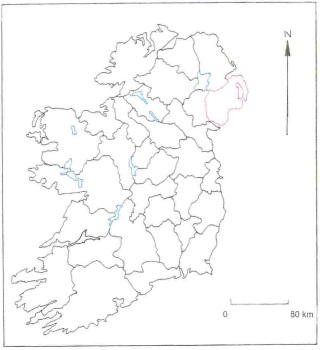
County Down is located in the north-east of Ireland (Figure 2) covers an area of approximately 2,630 km2.
The location of County Down within Ireland
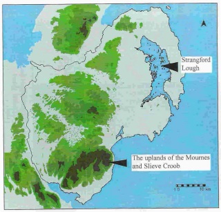
Within this area the highest points are Slieve Donard in the Mournes to the south-east of the county, which reaches 850 metres and Slieve Croob towards the centre at c. 600 metres. These uplands together account for less than one sixth of the total area of the county. County Down also has an extensive drumlin belt and a long stretch of coastline, including the shores of Strangford Lough. This lough however is enclosed at the southern end by the strong currents of the tidal race and to the north the tide goes out to expose wide tracts of dangerous mud, somewhat restricting its potential. These physical features of County Down can be clearly seen in Figure 3.
The physical environment of County Down
Soils
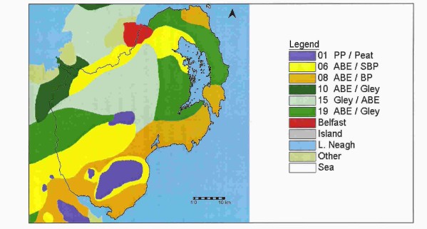
There are four basic soil types found in various combinations in County Down. The properties of each of these are examined below (after Mitchell 1986, 70 - 71) and their distribution can be seen in Figure 4.
Soil map of County Down
(after the General Soil map of Ireland, 1969)
Brown earths
Brown earths are some of the best soils in Ireland, suitable for growing crops. Acid brown earths, however, are less fertile and require limestone and fertiliser to be added to bring them up to this quality. There are many references in the Early Christian law tracts to the manuring of land, but no references, however, to the use of ground limestone or shells in this period. If these techniques were used to correct the natural deficiencies of the acid brown earths then they would have been useful agricultural soils with wide capabilities and very suitable for the Early Christian farmers needs. These acid brown earths can often be found on well-drained drumlins and this is where the majority is found in County Down.
Brown podzolics
Brown podzolics are usually quite heavy but can also be well-drained soils. The introduction of the coulter and mouldboard to the plough during the eighth century, however, would have allowed even these heavy brown podzolics to be cultivated (Kelly 1997, 470). The sandy brown podzolics are lighter and tend to have better drainage and would have been very much suited to the Early Christian farmer's needs throughout the period. On the whole these are productive and useful agricultural soils.
Gleys
A gley is formed when the movement of ground water through the soil is very slow, resulting in a wet water-logged soil. Because of this poor drainage and heavy, silty texture gleys are not suitable for growing crops but, depending on the drainage, they can be very suitable for pasture. With careful management Stout (1997, 107) has suggested that during the Early Christian period, pasture on predominately gley soil could still have been capable of supporting one cow per hectare.
Peat
As today, peat is generally not suitable for any agricultural use, although it was exploited for fuel.
Table 2 below lists the properties of these soils, (Gardiner and Ryan, 1969). From this we can surmise that the best soils in County Down are those with a combination of acid brown earth and brown podzolic, classified as type 6 and 8 soils on the General Soil Map of Ireland, and found in the rolling lowlands, towards the south of the county. Those soils which are a mixture of acid brown earth and gley, classified as types 15 and 19 on the General Soil Map of Ireland, and found within the drumlin belt, would have been used as pasture.
Throughout this study the soil types are referred to by the numeric code used on the General Soil Map of Ireland (1969) source map, followed, in brackets, by the characteristics of that code, with the principle soil followed by the associated soil, as detailed in Table 2. The following abbreviations are used:
PP Peaty podzol
ABE Acid brown earth
SBP Sandy brown podzolic
BP Brown podzolic.
The characteristics of the soil types in County Down
(after Gardiner and Ryan, 1969)
|
Soil code |
Principle /Associated soil |
Physiographic division |
Limitations to agricultural use |
Use range |
Area in Co. Down |
|
1 |
Peaty Podzols(75%) Climatic Peat (25%) |
Mountain and hill |
Very strong |
Extremely limited |
165.5 km2 |
|
6 |
Acid Brown Earths (60%) Sandy Brown Podzolics (40%) |
Rolling lowland (dry mineral soils) |
Moderate |
Somewhat limited |
551.8 km2 |
|
8 |
Acid Brown Earths (60%) Brown Podzolics (40%) |
Rolling lowland (dry mineral soils) |
Slight |
Wide |
551.2 km2 |
|
10 |
Acid Brown Earths (90%) Gleys and Peaty Gleys (10%) |
Rolling lowland (dry mineral soils) |
Not available |
Not available |
51.5 km2 |
|
15 |
Gleys (60%) Acid Brown Earths (40%) |
Drumlin (wet mineral and organic soils) |
Moderate / strong |
Limited |
509.5 km2 |
|
19 |
Acid Brown Earths (60%) Gleys and Peaty Gleys (40%) |
Drumlin (drier mineral and organic soils) |
Not available |
Not available |
405.5 km2 |