![]()

![]()
![]()
![]()
![]()
![]()
![]()
![]()
![]()
![]()
![]()
|
|
Click on the map below to visit some places around Kildare.
Kildare has grown considerably in recent years; the population of the county increasing from 71,977 in 1971 to 122,516 in 1991. There are more people living in the county now than at any time in its history. Part of this growth is due to a close proximity to Dublin, with towns such as Leixlip and Celbridge serving as dormitory towns. The other main centres of population in the county are Newbridge, Naas, Athy, Monasterevin, Kildare, and Maynooth. The chief industries are peat production, bloodstock, the manufacture of rope and carpets and Newbridge Cutlery, as well as food processing and textiles.
|
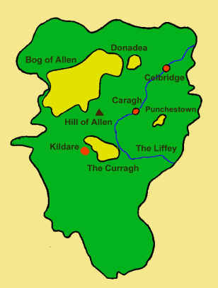
 County Kildare is located in Leinster, a region of rolling farmland on a
limestone base, containing the Curragh Plain and the vast
Bog of Allen. Kildare
is bounded to the south-west by Wicklow mountains and by Counties Meath to the
north, Dublin to the east, Carlow to the south and Offaly and Laois to the west
and southwest. Two major rivers cut through Kildare soil, the Liffey, which
flows in a loop from the Wicklow mountains through Co. Kildare and into Dublin,
and the Barrow, which flows through Athy.
County Kildare is located in Leinster, a region of rolling farmland on a
limestone base, containing the Curragh Plain and the vast
Bog of Allen. Kildare
is bounded to the south-west by Wicklow mountains and by Counties Meath to the
north, Dublin to the east, Carlow to the south and Offaly and Laois to the west
and southwest. Two major rivers cut through Kildare soil, the Liffey, which
flows in a loop from the Wicklow mountains through Co. Kildare and into Dublin,
and the Barrow, which flows through Athy.