Land
Rent Book
 In
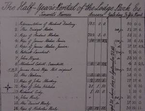
the last century most farmers did not own their farms. They rented the land
from landlords. One of the biggest landlord in this area was Edward Warren of
Lodge Park Estate. These pages are from the Lodge Park Rent Book which dates
from 1856 to 1898. They show the tenants of the estate and their annual rent.
Edward Warren also recorded the deaths of tenants and sometimes, details about
where they were buried. Some of the family names are still in the same townlands.
The Lodge Park Estate passed to Purdons early this century and the present owners
are the Burns Family.
In
the last century most farmers did not own their farms. They rented the land
from landlords. One of the biggest landlord in this area was Edward Warren of
Lodge Park Estate. These pages are from the Lodge Park Rent Book which dates
from 1856 to 1898. They show the tenants of the estate and their annual rent.
Edward Warren also recorded the deaths of tenants and sometimes, details about
where they were buried. Some of the family names are still in the same townlands.
The Lodge Park Estate passed to Purdons early this century and the present owners
are the Burns Family.
Source: Burns Family.
[Top of page]
Land Commission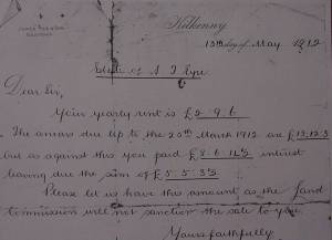
Towards the end of the nineteenth century a number of Land Acts
were passed by the Government. The last of these was the Wyndham Land Act (1903).
These acts made it possible for farmers to buy out their land from landlords.
Farmers were no longer paying rent to the landlords. They had
to make yearly payments to the Land Commission. This letter was sent to Gerry
McCarthy in 1912 and it relates to the purchase of land from the Land Commission.
He had rented the land from the local landlord, S.J.Eyre, and
had to pay any rent arrears that were still due before he could buy the land.
These yearly payments to the Land Commission were called "annuities".
It was like paying off a loan.
Source: Lil McCarthy.
[Top of page]
Land Purchase Account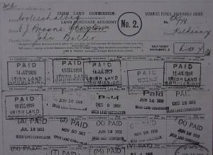
This is a page from the Land Purchase Account of land annuities
paid from 1911 to 1916 by the Butler family of Cooleshall. Their land had been
part of the E.J. Browne Clayton Estate, Freshford.
Source: Peggy Hamilton.
[Top of page]
Land Purchase Agreement
This is part of a land purchase agreement between Michael Grace
of Rathbeagh and Major General Nixon of Clone. Major General Nixon was a local
landlord who lived at Clone House and Michael Grace signed this agreement in
March 1908, to purchase 41.5 acres of land from him. The purchase price was
£464, which was just over £10 per acre.
Source: Mick Grace.
[Top of page]
Land Survey Book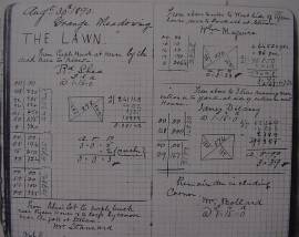
This page is from a land survey book of Michael Cuddihy, who taught
at Lisdowney N.S. at the end of the nineteenth century. He lived in the teacher's
residence, which was part of the school. Mr. Cuddihy came from Blackwood. His
family home was where Bergins now live.
He measured land for farmers throughout this area. This page refers
to a field called "The Lawn" in Grange. Sometimes the land was measured
before being sold, but usually it was measured so that it could be divided up
and rented out to other farmers. Mr. Cuddihy also calculated the rent they had
to pay.
The land was measured with chains. Each field was divided into
triangles and the area was calculated by adding the area of the triangles. The
set of chains used by Mr. Cuddihy are now owned by Larry Hamilton. The chains
are still in good condition and can still be used.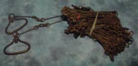
A land surveying chain had 100 links. It had little brass markers
to mark 10, 20, 30, 40 and 50 links from each end. The markers were like one,
two, three, four fingers and then a circle for 50 links - the centre.
The length of the chain was 22 yards (4 perches). One square chain
was 484 square yards (22 X 22). Ten square chains equalled one acre (4840 square
yards). this is English or "statute" measure.
There is also an Irish acre which is larger and Mr. Cuddihy also
had a chain for measuring in Irish acres. An irish chain measured 28 yards (4
Irish perches) and 10 square chains measured an Irish acre (7840 square yards).
An irish acre was sometimes called a "Planter's acre".
[Top of page]