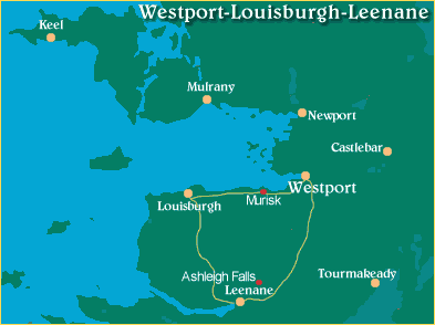
This tour will take you through some of the most varied and scenic landscapes in Ireland.
Leave Westport taking the R335 to Louisburgh. As you pass the Quay it is worth visiting the Clew Bay Heritage
Centre located at the Harbour. The centre provides a genealogical service and accommodates a wide selection of
historical and archaeological artefacts.
On leaving the Centre continue on the Louisburgh road. On your right enjoy the breathtaking views of Clew Bay
with its numerous islands, (tops of submerged drumlins) and to your left, the glory of Croagh Patrick, "Irelands
Holy Mountain" and one of Irelands most famous landmarks, soaring to a height of 762 metres. St. Patrick is
reputed to have spent forty days and nights praying and tasting on the reek in 441 A.D. as part of his efforts
to convert pagan Ireland to Christianity. A recent archaeological survey has shown that the summit of Croagh Patrick
was a Bronze Age Hillfort, complete with stone ramparts and dwellings.
At Murrisk approx. 6 miles from Westport on the right hand side of the road opposite Croagh Patrick is the
National Famine Monument, unveiled by President Mary Robinson in 1997, which commemorates all those
who died in the Great Famine of 1845 - 49. The road to the right leads to the ruins of the 15th century
Augustinian Murrisk Friary, on the shore of Clew Bay.
Towards Louisburgh there are many tine Blue Flag beaches along the coastline, Bertra, Old Head, and Carrowmore.
Louisburgh, (the name in Irish, Cluain Cearban, means The Meadow of the Buttercups), was renamed after the uncle
of the Marquis of Sligo who, in 1758, helped capture the French fortress of Louisburgh on Nova Scotia.
In Louisburgh, visit the Granuaile Visitor Centre and relive the fascinating story of Grace OMalley, whose exploits
form part of Irish folklore. The Centre also has an exhibition dealing with the great Famine, during which Mayo lost
over 100,000 of its population through death and emigration.
From Louisburgh take the R335 for Leenane, passing between the Sheefry Hills on the left and the Mweelrea Mountains
to the right. You will experience a succession of magnificent landscapes as you pass by Glencullin Lough and especially
Doo Lough, a long sheet of water with mountains rising steeply from all sides. To our left at Doo Lough, a small stone
monument reminds us of about 40 people who died in the region during 1847, at the height of the Great Famine, after
walking in vain from Louisburgh, seeking assistance at a Board of Guardians meeting being held at Delphi Lodge.
Continue on this scenic valley by the north shore of Killary Harbour this location was used in the making of the film
"The Field", which starred Richard Harris. The next stop is Leenane, a most picturesque village, where you can stop
for morning/afternoon coffee and visit the craft shop. Situated just above the village of Leenane on the N59,
the Westport-Clifden road is the Leenane Cuftural Centre. This Centre interprets the local sheep and wool industry.
Over 20 different breeds of sheep graze on lands around the centre and visitors can watch wool handcrafts, including
carding, spinning, weaving and the use of natural dyes. A wool craft shop and restaurant are some of the other
amenities provided.
On leaving the Leenane Cultural Centre you can either turn right and return to Westport on the N59 or turn into
the village of Leenane and turn right for Kylemore Abbey.
|

To see the next or previous drive click on the buttons below...

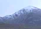
"...soaring to a height
of 762 metres...
Croagh Patrick"
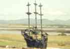
"Famine Monument"
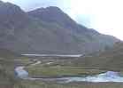
"Doo Lough"
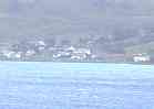
"Leenane on the"
shores of Killary Harbour..."
|