Doneraile Park, former residence of the St. Legers, Lords Viscounts Doneraile, has been developed into an amenity park, firstly by the Forest and Wildlife Service of the Dept. of Fisheries and Forestry, and subsequently, by the Dept of Public Works. This is just a brief account of the historical background of Doneraile Court, mainly making information from many scattered sources more readily available.
Historical Background.
Situated in the middle of Munster on a rich vein of land, the Doneraile area has been inhabited from an early period and according to local lore, played a role in the disputes of some ancient famous people. (1) In pre-Norman times, it formed part of what was described as "the noblest tuath" in the western part of the ancient territory of Fermoy (Fear Muighe), (2)" the tuath of Magh Finne in which is Cathair Dubhagain" (Caherduggan).(3) We are further told that " Ard gCeannais" (Scardgannon) and "Dun ar Aill" are one baile and (4) that from it are Hi Fhaelin(O'Phelan) and Hi Uirisi. The tract then states that Cill Fhada is the burial ground of this Tuath and it was (Mochaemoc) Mac Congairb that blessed the church.
Coming down further to the Norman period, the good land naturally attracted the invaders, and they settled in strength between the Nagle Mountains and the Ballyhouras. From an article published in 1909 by Mananaan MacLir, we learn that the Norman Synans settled in Doneraile and built castles in the area. This account is said to be derived from ancient documents of the Synan clan. We are told..."the Synans, of princely extraction in Wales, came to assist DeCogan and Strongbow as a body of bowmen in the invasion of Ireland in 1172. They eventually settled in Shandrum, Kilbolane and Rathgoggan (Rathluirc) in Co.Cork,and afterwards occupied Doonerfoyle or Doneraile."
A Giolla Chreest Synan founded a church at Rathgoggan and when he moved to Doneraile he built Teampaill a Carrig ( Carrigtemple) near Oldcourt house. Conor Synan (Roe) built another church at Cloustogue. To quote Mananaan Mac Lir again " their original dwelling place at Doneraile was a fort near Byblox built by Garod Synan head of the clan,and from thence they went out and,having waxed mighty,MacRichard Synan (Oge) built Richardstown castle, and Geoffrey Synan (Roe) built Castlepook.The Manor of Lisnagrough was was also built by William Synan. MacWilliam Synan Mor built Doneraile Castle A.D. 1402. It was this man who took particular care to have the family annals compiled.
In the fiants of Elizabeth, it is apparent that the Synans were embroiled in the wars of the Desmond Rebellion, and the clan suffered as a result. Portions of their land, which they held under the Roches, were granted to the Featherstonehaughs of Doneraile who held them until 1630 (MacLir). However in the year 1600 one Nicholas Synan was affluent enough to present a richly gilt silver chalice to the Friars minor in Buttevant.(Mac Lir).
The Synans hold on the lands of Doneraile was finally broken in 1636 when they released their interest in Doneraile to Sir William St. L:eger, Knight, Lord President of Munster, for "the sum of Three hundred pounds sterling current money of and in England in hand payed to us ". The lands mentioned in the release were:- "Downerayle, Ballyellis, Ballyandrew, Byblocks, Castlepooke, Knockshrahan, Kilbrack, Carkerbeg, Ballynorussell, Ardgillibert,Ardadam and Carrigines ..conteyning by common estimation Thirteen plowlands bee they more or less and now in the actual and real possession of the said Wm. St. Leger." The release is signed by " Nicholas Shinan" and " Cateline Shinan " and (their marks) "Francis Synan" and " Andrew Synan.
Though no longer lords of the land, the Synans maintained a presence in Doneraile. In 1642 they built the Red House, also called Doneraile House and afterward, Oldheadinn, in the Main street of Doneraile, where a branch of the family lived until 1830. The house was demolished in 1830 by the Creaghs.(Mac Lir)
St. Legers.
The St. Legers were a Norman family who accompanied William the Conqueror to England, and settled in Kent. Sir Anthony St.Leger was sent to Ireland in 1537 by Henry VIII to oversee the dissolution of the monasteries, and in 1540 succeeded Lord Leonard Grey as Lord Deputy of Ireland. His grandson Sir Wareham St. Leger was chief Governor of Munster and died on the 1st. March 1600 from wounds received outside Cork, where he met in single combat Hugh Maguire - Lord of Fermamagh - who also died in the encounter. Sir Wareham's son, Sir William St. Leger was made Lord President of Munster by Charles I on April 4th. 1627, when he resided in Mallow. In 1627 Mallow was exempted from a tax to support the army because Sir William resided there !. Amongst other things he ordred a ban on football and hurling on the streets of Cork, which the Corporation are said to have carried out.
The transfer of Doneraile to the St. Legers is best traced from 1593 when the Synans leased Doneraile to " Francis Wainman of Mallo, gent." and enfoeffed it to Sir Thomas Norreys for £50.In 1595 Sir thomas Norreys, thomas Butler and Nicholas Shinan "of Newtowne Donerayle Co.Cork, gent." granted to Francis Waynman of Donerayle, Co.Cork,esq. " the castle, manor and four plowlands of Donerayle". In 1623 Sir Sir Frauncis Wainman of Donniraile, Co. Cork,Kt. son and heir of Frauncis Wainman, esq. deceased granted to "Thomas Bettesworth of Moallowe, Co.Cork,esq. and Andrwe Arnold of Moallowe, gent.,the castle town lands and tenements etc in Downeraile".
In 1629-30 a conveyance by "Sir Francis Wenman of Caswell, Co.Oxon., Kt., and Thomas Bettesworth of Moyollo to Sir William St. Leger,Kt. and Lord President of Munster, for £1,800 , of the castles, towns and places called Downeraile, Ballyellis etc. etc."gives us the first involvement of the St. Legers in Doneraile.Other deeds listed in the Doneraile papers show them buying out the interest of any other party having a claim in Doneraile, culminating in the release by the Synans in 1636 noted above. Their hold on the lands of Doneraile and parts of Tipperary were further strenghtened by a grant from Charles 1 in 1639, called the "Black Letter Patent of Doneraile Estate" The St. Legers were to retain unbroken possession of Doneraile Park and Court down to 1969, when the Dept.of Lands took over the remnants of the estate. ( Cork Examiner 28/11/69).
The St. Legers and Doneraile Castle.
Having come to Doneraile, Sir William St. Leger made his castle the abode of the Presidency Court of Munster. As such it must have been the period when Doneraile was of greatest official note. Around the castle we can see the settlement of officials and artisans expanding, with accomodation perhaps for litigating parties who would have to come here with their legal wrangles during that period. There must also have been accomodation for a respectable garrison,and across the road we have the townland name of Horseclose, which could have its origin in the castle stables.In recent years, during tree planting operations large areas of paving stones were encountered north of the castle site,between the Beech Walk and the main avenue, as well as some road paving under the soil leading eastwards into the North park.
When the 1641 rebellion broke out, St. Leger took to the field at the head of his army, but ill health soon ended his career. While he was acknowledged to be a good soldier, he was also very hasty, and his indiscriminate hanging of innocent and guilty during this campaign is said to have helped spread the rebellion in Munster. After his death in Doneraile in 1642, his son in law Lord Inchiquin took over the government of Munster, bur the office of Lord President was allowed to lapse owing to the turmoil in England. In 1645 the Irish Confederate army under Lord Castlehaven captured Doneraile and burned the castle and part of the town.
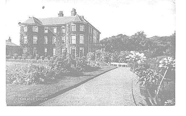
Meanwhile St. Leger's eldest son, another Sir William,was killed in the battle of Newberry in England in 1644, and the estate in Doneraile went to his second son, John , a captain of the local militia. The castle was rebuilt during the 1660's and garrisoned against the threat of a French invasion ,and later when the St. Legers had moved to Doneraile Court, it was used to garrison a troop of horse. John St. Leger died on the 31st of March 1696and was succeeded by his eldest son Arthur. On the 23rd. June 1703,Arthur St. Leger was created Baron Kilmayden,in Co. Waterford and Viscount Doneraile, Co.Cork. He died on the 7th. July 1727 when he was succeeded by his son Arthur, the 2nd. Viscount.The St. Legers were now established in Doneraile Court on the south side of the Awbeg river. It has not been firmly established when the St. Legers moved house, and information on them between 1645 and 1727 is very scanty. The date1725 on the front of Doneraile Court has lead to the belief that it was built on that date, but this is challenged on two fronts. First we have the story of the Lady Freemason. This relates that a daughter of the first Viscount overheard a meeting of the Freemason Lodge No. 44 being held in Doneraile Court. On being discovered, it was considered necessary to induct her into thee Freemasons to secure her secrecy. The room in which this event is said to have taken place is traditionally pointed out as being on the right hand side of the present entrance hall of Doneraile Court.The Lady Freemason's tombstone records this event as having taken place in 1712. Secondly it is the opinion of some people that the architectural features of the basement area put the building back into the late 17th. century at least. The most likely theory then, is that the original house on the site of Doneraile Court was the home of some of the St. Legers from the 1690's at least, and that 1725 is a date of major renovation. Whether John St. Leger reared his family here we do not know, but the 1st. Viscount may have occupied it soon after 1690, when he got married. Hopefully, architectural historians will some day read the history of its walls from the vaulted basement of the central house to the 19th. century bows and front porch.
Doneraile Park contains 400 acres within its wall today and its sweeping landscapes echo the days of landlord grandeur when the Lord of the Manor was the law of the land in the locality, and had the power to plan and implement the decoration of his residence on a grand scale. It also reflects a rather bleak era for the Irish people, but today the wheel of fate has turned, and the ordinary people can divert themselves in, and enjoy the beauties of, the park that former landlords created.
LANDSCAPING.
From the historical point of view, within the confines of Doneraile Park can be traced the development of estate-landscaping over a period of three hundred years.Starting with the 17th. century walled and terraced garden centred around the old castle,we can trace a gradual process of change to the late eighteenth and early nineteenth century layout. This landcsaping on a grand scale, which was brought to perfection in England by people like "Capability " Brown, is still the dominant feature in Doneraile today. Based on the centre piece of Doneraile Court, great vistas radiate out over the landscape, using water in the hollows,and uninterrupted grassland reaching off around groves of trees to the perimeter woods. Into this framework less spectacular changes have been introduced, as new species of exotic plants became available, and to satisfy the particular interest of succeeding occupants.
The 18th. century landscaping has been particularly enduring in Ireland because it is a very simple concept based on natuiral native ingredients.It entails making the most spectacular use of water, grass and trees on an undulating countryside which enjoys a moist oceanic climate. The simplicity of the concept should not blind one to the artistry needed to produce the spectacular effect. In Doneraile Park the Awbeg river has been ponded with weirs to give large pools of water in the hollow. Likewise the fishponds or "canals" are artificial creations. Fences, instead of being built up are sunk into the ground (ha-ha's) about which there will be more later. to leave the landscape free of obstacles. Groups and bands of trees have been expertly sited to give the effect that the open grassland areas are clearings in a primeval wood.
In the park, the refurbished castle north of the river was still the main feature in1728. It stood in the area now occupied by the Pound and a residence with garden and former forge. The castle yard was where the Dept. of Public Works now have their machine and storage yard, with an opening straight on to the road - the pillars of which can still be seen in the demesne wall. Some buildings stood against the road wall and the north wall of the yard.Around the castle, on its grounds are clearly depicted the gardens, orchards and groves of trees which were features of the 17th. century garden.
The castle garden stretched down to the river in three rerraces, in what is now referred to as Jones' garden. Each terrace had rectangular plots, probably demarcated with hedging, inside which were patterns of beds and paths, all drawn in great detail.The walls around the area are still there today, and the three terraces are clearly defined. Leading out from the castle along the top terrace, a straight path led through bowed walls eastwards to further rectangled patches outside. This is an extension of the walled inner garden, and reflects the trend to extend the garden landscaping out into the farmland in more secure times. This bowed wall can still be seen but the opening is now walled up.
What is now the "Beech Walk" was referred to as the "Ash Walk" in 1728. It did not open onto the Turnpike road as it does now.It stopped at the eastern wall of the castle yard. Between that and the road was the inner yard of the castle,with houses along the inside of the road wall where the gate to the Beech Walk now stands,and further houses along the wall of the yard.There was open space where the forge and dwelling houses now stand. Above the Ash Walk was the Upper Orchard and above that an Oak Grove, while along the lower areas of the present car park was the Lower Orchard and below that a Fir Grove. There was no access from within this area to the present Doneraile Court.
The "Great Meadow" stretched from the yard wall north towards the Turnpike, including the Tennis grounds. The Deer Park was to the east at both sides of the river, from the lower orchard across the "inches" and up to the Fish Pond lane. Physical features of the surrounds of the castle can still be traced on the ground, and present work is carried out to cause as little disturbance as possible.
South of the river, things were much different than they are today. Main St ended in Mallow Lane as it does today,but the New Road was not yet built so there was no junction at the top of the street. Neither was there a gate into Doneraile Court. A line of single story houses on each side of the street, with long gardens behind them stretched up the Mallow Road.
Fish Pond Lane. The road to the south from Doneraile was 'Fish Pond Lane' which took off from the Main St. opposite Convent Rd. - ( then called Buttevant lane) . Fish Pond Lane ran right across the front of Doneraile Court, and can still be traced between the two fish ponds and through the South Park to Ryall's Cross. Along the side of the track inside the South Park stands a large stone, locally known as the 'Toll Stone' with some peculiar holes in it which seem to indicate that a toll gate stood at this point at some time.
A large two story house is shown where Doneraile Court now stands, showing that the original foundation here was a house on the side of Fish Pond Lane.A garden stretching towards the canal was approximately one hundred yards each way. Here again were square and rectangularly laid out plots, with paths in the fashion of the time. On the town side a row of single story houses stretched up on both sides of the lane from the Main St. to within a short distance of the Court. Across Fish Pond Lane opposite the Court was another walled garden with paths rectangles and orchard which reached about two-thirds of the way to the river. Between that and the river was a Fir Grove. This garden would have enclosed the area in front of the Court where the larch and copper beech trees now stand, and its eastern wall continued down to the river to meet a similar fence around the fir grove on the other side. The Deer Park was downstream from these two fences. The present wooded area and Lime Walk of the Pleasure Ground was simply 'Nagles Fields'.
Smith 1750:
The next source of reference is Dr. Smith, in 1750. He describes Doneraile as.."....one of the most pleasant and beautiful villages in this kingdom" but was .." indebted for the greatest part of its beauty to the fine house and extensive improvements of Hayes St. Leger Esq. situated on rising ground at the south east end of the town, facing the river Awbeg, which is formed into a fine cascade and reservoirs........the outoffices are large and regularly built; the gardens well laid out and of a very considerable extent. In this is a wilderness and labyrinth; and towards the foot of the gardens is a canal of 370 yards long and 140 yds broad, well stocked with fish. The water is constantly supplied by a large wheel that casts up a part of the river Awbeg into a reservoir, which is conveyed underground into the canal, and returns back over a cascade onto the road. On the other side of the river are pleasant lawns, and an extensive deer park, well planted and enclosed: and to the east of the house is a fine duck decoy. Near the bridge,to the west end of Doneraile, the river is broad and deep, being retained in a fine basin for supplying the cascades formed by it as it passes the above improvements; and it is adorned with islands, planted with groves of fir, which add an inexplicable beauty to this place."
Here we have a record of the existence of the weirs and cascade on the Awbeg in 1750, which are not shown on the 1728 map. The main weir, built of cut limestone, broke down around the 1920's, according to local people who remember it.The cascade and associated canal got silted up, and became overgrown with scrub and bushes as a result. Since 1978, the canal has been dredged and the cascade uncovered, while a new concrete weir ,to the design of the Dept.of Fisheries engineers, replaced the old one. Today,this excellently engineered eighteenth century water feature is the centrepiece of the amenity development of the park.
Smith draws attention to well laid out and extensive gardens, by implication reaching down as far as the canal or fish pond in what is now referred to as the "Pleasure Grounds". This gives us a rough date for the enclosure of this area as a garden or pleasure ground as it was plain "Nagles Fields" in 1728. The wilderness and labyrinth are no longer there, but the canal, well stocked with fish, has been joined by the smaller lower pond. The upper pond was kept supplied by a water wheel, and the water cascaded out on to Fishpond Lane on its way back to the river.
Young 1777 : In 1777, Arthur Young took in Doneraile in his "Tour of Ireland" and commented again on the lawns, woods and cheerful aspect of Doneraile Park. He elaborates on the water wheel, saying it was"....an improvement on the Persian, which raises a regular stream 28 feet; the stream which turns it is confined by a double wall to the exact dimension of the boxes which take in the water, and it works constantly and regularly without trouble or expense".
There is no trace now of the water wheel, neither is there any tradition of its existence or location left in the locality.Young's description would suggest it was located on a narrow stream, such as flows from powerful springs in the Lady's Well area,and the remains of masonry foundations further along this stream may indicate the location of the water wheel. This site is hidden from the house, and would have been an out of the way place before the present avenue system was built. In long dry spells nowadays, the canal waters go very low as the catchment area is very small, indicating the need for the water wheel in bygone days when the supply of fish to the lord's table was a matter of importance.
Young also noted that near the house was shrubbery with paths through new plantations. This must refer to the Pleasure Grounds - Bird Enclosure area, and may give us a date for the Lime Walk and other plantations there.Like Smith, Young noted that the North Park was was " entirely margined with wood". However he noted another innovation in the form of a cottage in a wooded scene with the Park lawn rising above it, the work od Lady Doneraile, and which was a credit to her taste.
Nineteenth Century: In 1810 the Rev. Horatio Townsend in his "Statistical Survey" noted the " great ornamentation" etc. etc. of Doneraile Park. He mentions the " late Lady Doneraile, a woman of most superior understanding" who did much to embellish the Pleasure Grounds. Dr. O'Donovan (Ordnance Survey), described Doneraile Park in 1817 as " a very happy mixture of the English and Flemish style and picturesque nature ". He visited " a sweet cottage erected from a plan of the Hon. Miss St.Leger, who superintended the building. It is situated on a small island round which flows Spencer's Mulla. The interior consists of a very elegant and commodious apartment."
This single roomed cottage, which presumably is the same one mentioned by Young forty years earlier, was situated on an island on the Awbeg near where the stream from the canals joins the river. It's foundation only can be traced on the ground at present, and its garden has given way to a laurel and sally wilderness. It would have been a garden tea-room or "Gazebo", well removed from the main residence, and again typical of the fashion on estates of the time. O'Donovan also mentioned the "Forest garden" planted by Mrs. Stawell, a daughter of Lord Doneraile, "formed in an open space, near the fine piece of water". This must be near the upper canal. Windele in 1853 mentions magnificent old trees in Doneraile, especially oak, elm, ash and Spanish chestnut. He mentions an oak tree for which £60 was offered, its bark valued at £20; reminding us of those pre-industrial age times when the oak tree was one of the most valuable items of commerce. Its bark was needed to tan leather, and its hard, strong and durable timber was put to a multiplicity of uses.Irish oak is still a most impressive feature of Doneraile Park, with some massive boles op to 300 years old. The elms, unfortunately like elms everywhere in the locality have suffered the ravages of Dutch elm disease in recent years. Lewis,(Topographical Dictionary of Ireland 1837) noted the extent and beauty of Doneraile park, " intersected by the river Awbeg, over which, and within the demesne are some neat stone rustic bridges" He noted the recent addition to the mansion of " a large conservatory stored with the choicest of plants", (later known as the Orangery.) Lewis was writing at the time of the first Ordnance Survey, and the 1842 issue of the 6" maps gave the position as it had changed since 1728, and as it is, with few exceptions today.
The biggest change to be noted on the Ordnance maps, which was missed by contemporary commentators,was the closing of the public road which had run through the Park, called Fishpond lane, and the opening of the New Road around the west and south wall of the estate. In the 1823 Doneraile rental there is a mention of tenements on the New Rd., which meant it was well established by then. A gate was first put across the entrance to Fishpond lane, and the pillars can still be seen on the lane behind the arch across from Convent Rd. The houses on each side of the lane were cleared away,and eventually the house through which the present arch runs was built across the opening to the lane.A public right - of - way was always maintained here, and now there is a pedestrian entrance to the Park for the convenience of public entry. Hand in hand with the closing of Fishpond Lane went the making of the present avenue and entrance gates to the court from the top of the Main St. This led from the court on to the Mallow Rd., giving the St. Legers a direct route to Mallow, which with its Spa in full swing was the social hub of the locality.
The next major change to be noted is the internal avenue system,with the stone and rustic bridges mentioned by Lewis. The architecture of the main gate on the Turnpike road is reputed to date from the late 18th or early 19 th. century, and probably coincides with the closure of Fish Pond Lane. The mains avenue winds for a mile through the Park on its way to the court, through open grassland, groves of trees and past vistas of bridges, river and the court itself. This was the period of final landscaping in the Park that we have today, and as Bence-Jones noted (Irish Times 26/3/63 ) led into " the golden age of Doneraile, when the village, immediately behind the house, was the most fashionable place in North Cork. The line of gentlemens carriages outside the church on Sundays was said to be a mile long."
Tree lines were established, vistas created, and ornate bridges built as features on the landscape. The treble arched avenue bridge of limestone, sited on a curve of the avenue over the Awbeg river, was highly decorated on the upstream side, which would be viewed as you travelled in either direction. Likewise the stone footbridge near the cascade was designed to be viewed from the avenue, and is a complicated structure going at an angle to the canal over which it is built, with two slanted arches in the direction of the stream.
The third stone bridge, known as the " Hunting Bridge" is situated at the lower end of the Park, giving access between the North and South parks. It is a lovely cut stone, humped backed bridge, which spans the Awbeg with a single arch. It is reached by following the avenue through the South park.
Fish Ponds:The building of this avenue to Creagh Castle gate, had the side effect of creating the lower or smaller fish pond. This pond is now being developed for wild fowl and some geese and duck are already established, with suitable grazing areas on either side. These fish ponds, because of the limestone nature of the surrounding soil, are very rich habitat for water insects etc., and can support a large stock of fish and bird life. Fish ponds were another feature common to estates, castles and monasteries in by-gone days, acting as a handy larder from which fish could be easily obtained as needed.
Like a lot of ancient utilities, fish ponds have gradually evolved into items of decoration. In the upper pond, water lillies were planted over half a century ago, according to local tradition, and have grown so rampant from neglect as to have become an eyesore, completely blotting out the water in Summer. Half of it has now been dredged of lillies and accumulated mud, giving the canal a new lease of life. Today there are pike perchand roach in their weedy waters, but in 1823 the upper fish pond was rented for £4 per year to Robt. Atkins, while the lower pond and a tenement were rented to Richard Atkins for £8-19s -!0d per year. (Estate Rental List).
Another major element in the landscaping of the eighteenth and nineteenth centuries was the "Ha-Ha" or sunken fence. This evolved in England in the early eighteenth century and quickly spread as an estate feature. It allowed stock to be fenced out of the immediate garden or house grounds, without obstructing the view. There are some fine examples in Doneraile, around the Pleasure Ground near the Court and around the Tennis Ground in the North Park.
Old Trees:Grove-White (1913) noted the fine beech and fir (Scots Pine) trees in the Park, while in the Pleasure Grounds and in front of the Court were " some magnificent larch trees, believed to be the oldest in Ireland". These fine European larch are still with us, though knarled with age. They are a mountain variety, with branches sloping down and out from the trunk, which enables the tree to shed heavy snow and ice without breaking its branches. Fitzpatrick(Scientific Proceedings, R.D.S. Vo.20) , noted that European larch (Larix decidua), was probably first planted in Ireland about 1738. He also noted that five trees in Doneraile park were said to be of the original importation sent by the Duke of Atholl.
Other interesting trees in the Pleasure Grounds include a cork-oak, Chosan palms,plane tree,redwoods, Spanish chestnut, box ,yew, cherry, Variegated sycamore, as well as the fine lime walk.The cork-oak (Quercus suber ) is native to Portugal and Spain, where they strip the bark for the cork every ten years without harming the tree. Its foliage is similar to the evergreen or holm-oak(Quercus iles ) another Mediteranean tree that can be seen in Doneraile Park.
Early Twentieth Century:Grove-White mentions improvements "..... effected in the demesne during the past few years. The river has been widened at the water fall opposite the front of the house; new paths and roadways have been constructed; new forcing houses have been added to the gardens; red deer introduced about 1895. There is also a herd of fallow deer." Rainbow and Loch Levin trout had been introduced into the river. Lord Castletown had enclosed the upper canal and a portion of the Pleasure Grounds to create the "Bird Enclosure", in which rare aquatic birds - rheas,demoiselle, cranes etc.,were kept. The Bird Enclosure is still with usas a name for the area, but the rare birds have long since gone. A heronry of fifteen nests noted by Grove - White is still there at the top of the Bird Enclosure, but the number of nests in 1982 was reduced to four.
The red deer introduced in 1895 are still in Doneraile Park, but the fallow herd has disappeared. Fallow deer would have been the animals of the deer park from the 17th. century, and were the more common deer emparked in demesnes and estates since the Normans introduced them to Ireland. At present the red deer are kept in the North Park enclosure while the South Park is also enclosed for deer.
Grove-White also informs us that " The Doneraile Lawn Tennis and Croquet Club" was established in 1910, and that a former club was held on the same ground some time before.From this club we still have the name of thr Tennis Ground applied to the area of the Park nearest the Turnpike cross, which is enclosed by a " ha-ha " on two sides. In April 1912 the Doneraile Golf Club was established in the North Park " by the kindness of Lord and Lady Castletown.
The winds of change that blew through the first half of the twentieth century had their effects on Doneraile Park. It was an era of gradual decline for the estate, and when there was no successor to the title of Viscount Doneraile, the Land Commission got involved in 1969. It was purchased by the Forest and Wildlife Service of the Dept. of Fisheries and Forestry in 1971. Doneraile Court and out-buildings were leases to the Irish Georgian Society, who have under taken to restore them. In 1978 work began on restoring the remaining four hundred acres of parkland to their former grandeur. A large car park has been established as a new focal point, and all the avenues, paths, waterways and bridges are being restored. Deer parks have been refenced and aging woodlands are being replanted. Doneraile Park now belongs to the people, and hopefully will be a place of peace and enrichment to its visitors for years to come.
Note: I am entirely indebted to Mr. Seamus Crowley , head of the National Parks and Wildlife Service, Doneraile Park, who is a local historian of note and also Secretary of Mallow Field Club, for permission to reproduce the above which first appeared in the Mallow Field Journal No.1 in 1983. An update on Doneraile Park can be seen in the linking article entitled Doneraile Forest Park & Demesne.