TRANSLATE
THIS PAGE AUTOMATICALLY BY COMPUTER
|
||
| Home |
TRANSLATE
THIS PAGE AUTOMATICALLY BY COMPUTER
|
||
| Home |
|
|||||||||||||||
The photographs below are from a few sections of what remains of the Esker Riada ridge in the New Inn area of East Galway. |
(All of the photographs were taken between January 7th & 8th 2001) |
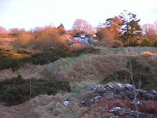
Entering the village of New Inn (East Galway) from the west ..... |
|||||||||||||
 |
|||||||||||||
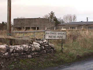
The quarry buildings by the roadside in the photograph above belong to Galway County Council. The Celtic words "An Cnoc Breac" on the above signpost literally mean "the hill with the speckles". Unusually for Ireland, the English placename of New Inn is not a corruption of some Celtic words. The two separate and unrelated names for the village are likely to have come from different periods in history, and for different sets of reasons. The name New Inn is thought to be from the 1800's. It is possibly connected with the period when fairly large numbers of wagon drivers began using the Esker Riada to haul merchandise back and forth between the two seaport cities of Galway and Dublin (which are more or less at opposite ends of the ridge). It is thought that a new inn of some kind came into being locally where the wagoners could change horses, and/or stay the night. This new addition to the area might have involved little more than a local resident making some small changes to his or her home (or business premises). The Celtic name "An Cnoc Breac" may be much older than the English name "New Inn". Many of the local hills and ancient monuments are pockmarked as a result of people removing parts of them over the centuries (for various reasons). As can be seen in one of the photographs below, spotted effects can be produced in the damaged areas: and hence the Celtic name of "An Cnoc Breac" (Speckled Hill). |
|||||||||||||
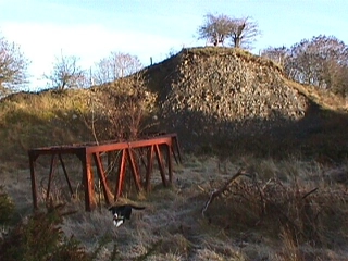
The crushing machine .... |
|||||||||||||
 |
|||||||||||||
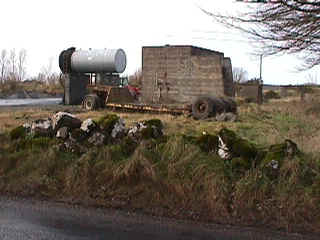
The building by the roadside in the photograph above shows the partly decommissioned structure which was built in the 1950's for crushing rocks from the section of the Esker Riada removed from New Inn by Galway County Council. |
|||||||||||||
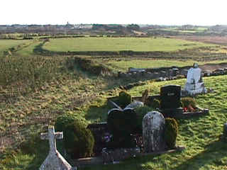
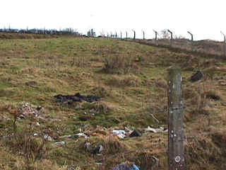
Where Site 93 (The Children's Burial Ground) used to be ..... |
|||||||||||||
 |
|||||||||||||
The fences in the above photograph show parts of the boundaries of the dump which was opened in New Inn village by Galway County Council in 1971. In this particular section, decomposing rubbish now replaces the sand and gravel which has been removed from the Esker Riada. Local residents managed eventually to have this particular dump closed down in 1989 because of the massive problems it was causing in the area: which included an enormous rat colony, and revolting air pollution. Disused plastic shopping bags and suchlike could also be seen stuck to many farmers' fences, and blowing around the local main road and nearby fields. Part of the uncovered rubbish can still be seen in the foreground of the photograph above. The buried rubbish in this area is understood to be in region of 50 feet deep, and some local people claim that at certain times toxic looking discharges (reddish in colour) can be seen seeping from it into a nearby stream, which later feeds into one of the local rivers. It certainly seems to be the case that most (and possibly all) of the fish in the area have been poisoned out of existence years ago: though this is not thought to be entirely due to discharges from the above rubbish tip. Up to and during the 1950's (at least), wild fish such as brown trout could easily be seen in the local rivers and streams. Now, they are conspicuous by their absence. The Children's Burial Ground referred to as Site 93 was located somewhere roughly in the middle of the top left hand quarter of the above photograph. Those who remember it say it was square in shape with sides approximately 10 yards in length. In addition to unbaptized children, this "Protected" Monument would almost certainly have contained adult human remains. Contrary to popular belief, such graveyards were not exclusively for children. Adult strangers who died while passing through the area would also have been buried in graveyards of this type - and many such adults would have been starving famine victims who wandered the Esker Riada in search of food. People who committed suicide would also be buried in such places. In Ireland, childrens' burial grounds of this kind can be up to 1000 years old, or more sometimes. (The original idea of excluding certain categories of people from normal Christian graveyards goes back almost to the time of Christ.) The stillborn twin brother of the late William Thomas Finnerty might well be one of the local infants buried at Site 93; his family home and birthplace is located just a few hundred yards away from the area shown in the photograph above. Site 93 was a Protected Monument, and it looks as though it was unlawfully destroyed (and some might feel thoroughly desecrated) by Galway County Council sometime during fairly recent times (i.e. after the mid 1950's). As can be seen on another page of this web site, President Mary McAleese, Prime Minister Bertie Ahern, Attorney General Michael McDowell, and two local newspapers have all been informed about this particular matter by letters sent through the registered post on December 29th 2000. |
|||||||||||||
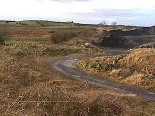
The Hill of Grange ..... |
|||||||||||||
 |
|||||||||||||
The remains of the ruined building on the Hill of Grange can just be seen near the middle of the skyline in the photograph above. The road shown here is one of several in the New Inn area leading off the Esker Riada in the general direction of Grange. It is thought that the original monument at Grange probably goes back to the earliest of times, and that it has been added to and changed by many different generations. Among other things, it was probably an important stopping off place where travellers could eat, rest, and wash; and it was almost certainly a place of worship during one or more periods in its history. As suggested below, the immediate area may also have been used for outdoor ceremonies of some kind which were attended by large numbers of people. The photograph below is taken from the Hill of Grange - with the camera facing in the direction of where the Esker Riada ridge used to be.
An extremely interesting looking piece of land can be seen in between the headstones and the top of the photograph above. It appears to have some kind of a relatively wide road going all around it. If this raised piece of ground of several acres was ever used for Celtic celebrations (or spiritual rituals) of the kind described in some reference books, thousands could have watched from all along the now disappeared section of the Esker Riada (which almost touched parts of the field furthest from the camera). As far as we know, the raised field shown above has never been subjected to any archaeological investigation: even though it and the surrounding area seem to be full of interesting features. Although it cannot be seen in the photograph, a river runs all along by the side of the raised piece of ground nearest the camera; and there are numerous stones strewn about its banks which suggest the possible presence of one or more Fulachta Fiadh type arrangements of the kind dating back to the bronze age (which was from around 2000 B.C. to 1200 BC).
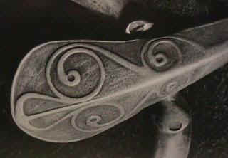
The La Téne style bronze snaffle-bit found at Attymon, which is understood to be now on display at the National Museum in Dublin, is shown in the photograph above. Apparently, uneven wear on opposite sides of the bit suggest it was used by horses pulling a two-horse chariot of the kind used by Celtic royalty. The bog in Attymon where this attractively decorated piece was found is just 4 miles or so to the north west of the raised field beside the Hill of Grange shown above. (See also: field damage at Grange.) |
|||||||||||||
| section | |||||||||||||
Cross section of the Esker Riada ..... |
|||||||||||||
 |
|||||||||||||
The above cross-sectional view of the Esker Riada in New Inn shows a sample of the kind of material deposited by the glacier which once covered this part of Western Europe. Often, the stones mixed in with the sand are many times larger than the ones seen here. For those who might be curious, the four legged amateur archaeologist in the above photograph has an interest in bones from all periods of history. A diplomat by training, she is on loan for a short period from the Ministry of Fun & Friendship in Tír-na-Nóg. Her full name on this particular assignment is "Gobnait FionnSneachta"; but, she is known as "Go-Be" for short - as in "go-be-quiet". (Tír-na-Nóg is a place in the Celtic spiritual world where the inhabitants never grow old, and the words of the name literally mean "the land of the young".) |
|||||||||||||
Still in regular use (January 7th 2001) - after 7,000 years or more .... |
|||||||||||||
 |
|||||||||||||
| The car in the above photograph is probably moving
along the exact same path which travellers used in ancient times. The Hill of Grange, Alloon, Kilconnel Friary, The Valley of the Suck, Clonmacnoise, Tara, Newgrange, and Dublin are all in front of the camera (to the east). The Turoe Stone, and the Rath of Feerwore where it once stood, are just three miles behind the camera (towards the west). The world famous Galway Bay is also behind the camera, and it is approximately 20 miles to the nearest part. Some of Ireland's earliest settlers very likely entered Ireland through the attractive and relatively safe waters of Galway Bay; and there is a tradition which claims that Galway was the port Christopher Columbus choose to exit Europe from when he set sail in 1492 AD to discover the New World on the opposite side of the Atlantic ocean. The Church of St. Nicholas in Galway City was built around 1320 AD, and during the middle ages St. Nicholas was commonly revered as the patron saint of sailors. There is reason to believe that Christopher Columbus almost certainly worshiped in this church in 1477, and his ideas about finding land somewhere far out into the Atlantic ocean may well have been inspired by stories he heard in Galway regarding St. Brendan the Navigator - an Irish monk who is believed to have succeeded in sailing to America in the 6th century AD. (Today, St. Nicholas is of course better know as the patron saint of children: i.e. Santa Claus; and some may be interested to know that The Church of St. Nicholas in the centre of Galway City is still open to visitors and worshipers each day.)
Page 1 (general Esker Riada information)
|
|||||||||||||
| bm10 |
|
VISITOR |
NUMBER | |