


|

Forts
Galway
Dún Aengusa, Inishmore
One of the finest stone forts in Europe, bodly stands on the edge of a 100 metre
cliff. The fort consists of three concentric 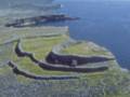 semi-circle enclosures surrounded by
walls and also has a chevaux-de-frise. semi-circle enclosures surrounded by
walls and also has a chevaux-de-frise.
Legend says that the fort delonged to Aengus, a chieftain of the Fir Bolg, banished
from the mainland after the Battle of Moytura.
Loughrea
(Baile Locha Riach The town of the Grey Lake)
A Norman settlement was found around a de Burgo manor estabolished after his conquest
of the country in 1235. Loughrea evolved into a well-defended medieval town. Today
only the town tower and an artificial watercourse, (the only town moat still functioning),
are all that remain of the medieval defences.
The ruins of the Carmelite Monastery founded by the de Burgos about 1300 can be seen
besides their present church.
East Clare
Beal Boru
The remains of Brian Boru's ring fort are located at the point where Lough
Derg narrows before reaching the town of Killaloe.
Grianan ring fort
Site of the hereditary home of the local rulers, the Dal gCais, is situated
on the southeastern side of a steep hill known as Crag or Cragliath, (Grey Rock)
a short distance away from Killaloe.
North Clare and the Burren
Carn Connachtach
Ballydeely
(5 km north-northwest of Ennistymon) is a striking bronze-age burial
mound, 8 m high and about 100 m in diameter.
Frost writing in 189,3 believed the correct name to be Carn Mac Tail,
the burial place of Mac Tail, son of Broc, chieftain of Corcomroe and
inauguration place of the chieftains of Corcomroe.
Folklore says that the cairn is the burial place of the defeated Connaught
army, (hence the name).
The region to the north of Doolin contains numerous cahers or stone ring
forts and earth forts (raths) surrounded by ditches.
Ballynalackan
To the south of the village is an upland area of great interest, scattered with
Stone-forts, megalithic tombs and remains of ancient churches.
There is a very high concerntration of habitation, (possibly medieval), to the
south of Ballyvaughan, which is interesting since the area was thought, at that
time to be outside the extent of Anglo-Norman settlement.
Cahermacnaghten
Over the top of Corkscrew Hill is the circular stone fort, which once housed one
of Ireland's most famous medieval law schools under the care and management of the
O'Davorens, a family of hereditary legal scholars and teachers. Donald O'Davoren is
credited as the compiler of both a Breton Law Glossary and "The prophecy of Conn of
the Hundred Battles" concerning the succession of the kings of Tara and the coming
of St. Patrick.
Rathborney
(Rath Bóirne- Burren earth fort)
(3 km from Cahermacnaghten, in the Feenagh Valley.) There is a medieval church on the site.
Caherballykinvarga
(Cathair Baile Cinn Mhargaidh - stone fort of the town at the head of the market)
1.5 km north of Kilfenora is a iron age structure of stone built with double ring walls
and a protective belt of upright stones for good defence. Interestingly enough, the fort
uses sharp limestone pillars set upright in the ground, a devise known as chevaux de fries,
as added defense. This strategy was adopted mainly by tribes of the Iberian Peninsula
(Spain and Portugal). Could there have been contact between the two regions in the Iron Age?
Ballyganner Region, offers a real sense of wilderness and has 5 megalithic tombs of
varying type. There are examples of a court tomb, gallery tombs and wedge tombs.
Poulawack
(Poll an Bhaic - hole or cave of the angle or bend)
is a large cairn,
excavated by Harvard archaeologists in 1934. They found the remains of 18 people, some
primative instruments and some bronze-age potsherds.
Caherconnell Fort
(Cathair Chonaill - Connell's fort
A strong and well-preserved ring fort on the Leamaneh - Ballyvavghan road.
Cathercommaun fort
one of the most elaborate stone built structures on the Burren, is situated on
a cliff edge. It has three ring walls, traces of stone houses and a souterrain
or underground passage. Cahercommaun was excavated in 1934 by Harvard archaeologists.
The structure dates from the 9th century.
Mid Clare
Mooghaun Fort
(Off the N18 road between Newmarket-on-Fergus and Dromoland.)
This famous iron-age ring fort, 'one of our most remarkable antiquities has three
great stone walls of which the outermost, oval in outline, measures 450 m x 300 m'
0 R1ordain, 1942.
West Clare
Doonegall Point
On the N67 between Doonbeg and Kilkee, one passes Doonegall Point and the remains
of a large promontory fort.
|
|


|