Home page Facitities Local amenities What our guests say What we charge Get in touch Make a reservation Directions Drives around Mayo Walk the Western Way Local Golf Courses Local History Photo Gallery

Irish Tourist Bord
Approved.


The Western Way is 120 miles long, running mainly through Mayo, but starting in Galway in the south and ending on the border at Sligo. Its appeal lies in the variety of landscape: from desolate wilderness to historic religious sites, covering bogland, forest, mountains, winding valleys and breathtaking coast. It starts on an ancient pilgrim path through the Maumturk Mountains of Connemara and the lnagh Valley, lined with picturesque white-painted cottages, and passing the neo-Gothic Kylemore Abbey proceeds to Leenane. There is a spectacular view here
across Killary Harbour to the Mweelrea Mountains.
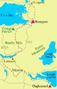
The next stretch takes in a short but spectacular crossing over the Sheeffty Hills, and the southern flanks of Croagh Patrick, where St Patrick spent Lent and convinced God to banish snakes from Ireland. Now some 60,000 people a year make a pilgrimage to the top, on the last Sunday in July, many of them barefoot. Clew Bay, studded with islets, is on your left, as you proceed to Westport and Newport. Now comes the lonely part. You pass Laugh Feeagh, at the foot of an idyllic valley, and head into the wilderness of the Erris and Tirawley bogs. You are in the Gaeltacht now. The path leads eventually to the Atlantic coast: after Killala, with its eleventh-cen fury round tower, it heads off to the May estuary (a big salmon river), and Ballina, from where winding country roads take you to the Sligo border.


Home Facilities Reservations Contacting us Gallery Getting Here Rates Amenities Golf Garden Menu Scenic Drives Western Way Heritage
Website Design by Alternative Times Westport