Portmarnock,
County Dublin, Ireland.
Portmarnock is town on the North Coast of County Dublin.
Originally fishing village with some holiday cottages it was famous for it's
magnificent velvet strand.
The Jameson family had a large residence near the beach, long converted
to a Hotel. The hotel has been recently upgraded and combined with a new
golf course which enclosed most of the area behind the sand dunes.
Death and regeneration of Portmarnock Strand.
The contours of Portmarnock strand change constantly during the year as sand
is moved to and fro by storms and wind. Extra beach has been created at the
southern end of the beach. A feature over the last few years has been the
deterioration of the sand dunes behind the strand. A series of photos taken
in January 2000 to show the extent of erosion of the dune system.
An attempt was made several years ago to stabilise
the front dunes but this was partially successful but was not followed through.
A grassy approach to the beach was created at the same
time as the stabilisation attempt. Railway sleepers were driven into the
sand several meters in front of the dunes and the area between the dunes
and sleepers was filled with soil. This has created an artificial access
to the beach from the roadway.
This area has now been extended by
Fingal County Council and, due to representations
from the Beach Committee of the PCA, it is being covered with sand instead
of soil and grass. The bare areas of sand here and down along
the beach are to be planted. The work is to be
partially paid for by both FCC and the Golf and Country Club Hotel. The work
was driven by the necessity to realign the fence
on top of the dunes to comply with planning permission.
It appears that the intention was to cover the dunes with soil for a distance
of 250m from the end of the present revetment. This resembles the works in
Malahide, where the dune system was covered and an area in the centre was
converted into a carpark.This idea was opposed by the PCA with the support
of numerous concerned residents. The plan has,
hopefully, been revised to accomodate our concerns.
BEACH UPDATE
 |
High tides over the last few years have led to
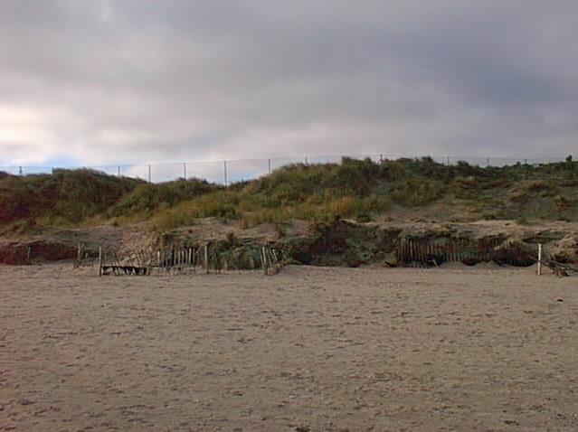
erosion of the face of the dunes as can be seen in the photo. The wooden
palings were put in several years ago by Fingal County Council in an attempt
to preserve dunes from erosion. They succeeded in places in causing
a large build up of sand and encouraged growth of marram grass.
The fence on the skyline belongs to the Portmarnock Hotel and Golf Links.
This fence is to be slightly repositioned according to the FCC plan.
Fingal County Council have placed sleepers in front of this
section of dunes in an effort to stop further erosion. |
| The deposition patterns be seen as lines across
the cliff face. The sand falling off the cliff forms slopes of loose sand
which blows away in high winds or carried away by high tides and during
storms.
With no marram grass to hold the sand erosion is taking place quite rapidly.
The landward side of this dune is cut away for a tee box while the seaward
side in undercut by the sea.
This dune has been demolished and recontoured by F.C.C. It
is intended to cover this and all other areas of bare sand with jute
sacking and plant them with marram grass to hold the sand. |
![[Image]](pict13.jpg) |
![[Image]](pict7.jpg) |
Changing contours of the dunes have caused a build
up of sand in some areas creating an open access to the Golf Links. In other
areas sand has been eroded from under the fence supports. |
| The layers of sand, which have built up over centuries, can be seen on
the face of the dune.
The height of the dune would have originally been level with
the marram grass at the crest. The face and some of the height of the dune
have been blown away without vegetation to preserve the structure.
Loose sand has been created by adults and children walking, running and sliding
on the face of the bare dunes. This loose sand then blows away in the wind. |
![[Image]](pict3.jpg) |
![[Image]](pict4.jpg) |
A trench cut for the fence by IMG in the top of
the dunes initiated this erosion which has been continued by walkers forced
up from the beach at high tides. The fencing in of the back section of the
dunes has put added pressure on the front dunes.
Before the erection of the fence walkers could choose to follow several paths
behind the dunes. |
![[Image]](pict5.jpg) |
Inside the fence grass has replaced the bio-diversity
which is a feature of this type of ecosystem. Removal of the organic layer
from much of the course and replacement with a single grass type made the
application of fertilizer essential. The sandy soil meant that any water
and fertilizer drained rapidly into the ground water and Baldoyle estuary
a special area of conservation. The estuary is the
winter feeding ground of almost 20% of the world population of light bellied
Brent Geese. |
Large segments have been cut out of high dunes
to create tee boxes at high levels. This contributes to the instability of
the dune system. Isolated patches of the original vegetation are visible
around the course.
|
![[Image]](pict8.jpg) |
TOP