

|
|
The Village Street
Well RoadOn the left is the Well Road, site of St Colmcille’s Well. It is about 50 yards down this street on the left hand side, and it is about ten or twelve feet below the level of the road. On the last step, there are some hollow marks which are reputed to be the traces of St Colmcille’s toes when he stepped from the top of the Round Tower to this spot. The well sprang up where his feet touched the ground. Its water is reputed to have health-giving properties especially as a cure for sore eyes. The well was refurbished by Swords Historical Society in 1991. CoolbanagherThe Old School House Restaurant, formerly called Coolbanagher, is located on this road. It was built in 1835 as the Infant School for the Old Borough School. Home ¦ Class Photographs ¦ Dates for Diary ¦ General Interest |Information ¦ Local History ¦ Newsletters ¦ Our Work ¦ Sporting Activities ¦ Useful Links ¦ Web Safety |
© St. Colmcille's B.N.S., Chapel Lane, Swords, Co. Dublin |
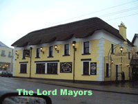 The
first road junction (at the traffic lights) marks the beginning of the village
street, and it was also the location for the “Turnpike” up to the 1860s. A
turnpike was a barrier in the road which was turned on the payment of a toll by
the coach drivers. This money was used to maintain the roads before the County
Councils took over this task. [The turnpike at the other end of the town was at
Lissenhall]. The pub on the corner is now called the Lord Mayors after Joe
Savage who was made Lord Mayor of Swords around the time that his family took
over this public house.
The
first road junction (at the traffic lights) marks the beginning of the village
street, and it was also the location for the “Turnpike” up to the 1860s. A
turnpike was a barrier in the road which was turned on the payment of a toll by
the coach drivers. This money was used to maintain the roads before the County
Councils took over this task. [The turnpike at the other end of the town was at
Lissenhall]. The pub on the corner is now called the Lord Mayors after Joe
Savage who was made Lord Mayor of Swords around the time that his family took
over this public house.