 |
I would like to acknowledge the indispensable assistance which I have received from the Ordnance Survey maps. I hope the Ordnance Survey Office of Ireland don't mind me reproducing this map of the national grid below. I love maps and over the years I have bought practically every road map the OS have produced, including most of the 1:50,000 discovery series. As well as that I have spent a small fortune on the six-inch-to-a-mile sheets corresponding to a wide sweep of my home area.
|
|
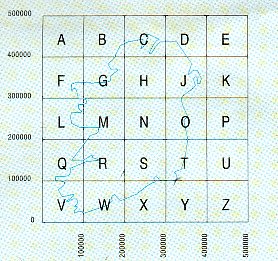
Ordnance Survey Grid References The Grid Reference numbers I am using in these pages follow (sort of) the OS grid of Ireland as shown on the left. The country is divided into 25 squares with letters to name them and numbers for the boundary lines. So Dublin is in square O as you can see. However, in order to give a more accurate reference for an area you must use the line numbers. This is done by reading the value across the bottom first and then up along the side. his is the way one locates a place from practically every kind of a map in the world and it is often learned by remembering that "you must crawl before you can stand up". |
|
|
When you look at an OS map, the numbers you see in the margins are subdivisions of the main dividing lines. For example, the lines shown as 300000 in the above grid appear as 30 but the area from that to 40 is lined out in ten subdivisions numbered 31, 32, etc. In my reference numbers I have subdivided each of these
tenths into a hundred parts. So I would refer to Notown by the numbers I try to be as accurate as possible. In my maps (the four
new OS 'Holiday' Maps for North/South/East/West to a scale of 1:250,000) each
grid is 40cm. X 40cm. I have a ruler to measure how many cm across and up must
I go in each square. So 26cm, for example, expressed as a percentage of 40cm is
|
