
|
From "Lewis's Topographical Atlas" (1837) A village, in the parish of Skull, Western Division of the Barony of West Carbery county of Cork, and province of Munster, 8 miles (w.s.w.) from Skibbereen; containing 601 inhabitants. The village is situated on a new line of road formed by the Board of Works from Skibbereen to Rock Island; and derives its name from its position at the confluence of three streams, whose united waters are crossed by a handsome stone bridge, below which they expand into a small but secure haven, near the termination of Roaring Water Bay. It consists of a long and irregular street containing about 100 houses, some of which are large and well built; and is rapidly increasing in size and importance, particularly since the formation of the new road, which has made it a considerable thoroughfare, aided by its propinquity to the copper mines of Cappach and the slate quarries of Audley's Cove and Filemuck, which renders it well adapted for business. |
|
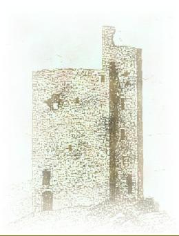
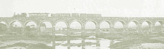
Ballydehob Beal Ath an Da Chab (ford mouth of the two openings) Ballydehob is a microcosm of Irish local history and legends and folklore abound in the locality. At the dawn of the Bronze age (2200-600 B.C.) , copper and some say gold were mined on Mount Gabriel, and just outside the village. At the same time Stone circles, Wedge and boulder tombs were constructed in the area . The Celts arrived around this time and the various clans fought for dominance, until the eventual emergence of the McCarthy's and O'Mahonys as the rulers of the area surrounding the present village. A string of castles along the coastline bear testament to their strength, and to the importance of the area. Kilcoe Castle was the McCarthy's most westerly stronghold and is probably West Cork's best preserved castle,( the actor Jeremy Irons is at present extensively restoring it). In 1602 soldiers led by Sir George Carew, Lord President of Munster descended On the area in a successful bid to break the power of the Gaelic chieftains. Their Passage through West Cork was described in "Pacata Hibernia" by Thomas Stafford, told of course from the invaders point of view, but interestingly, and probably uniquely for the time, a contempary Irish account can also be found in " Historicae Catolicae Iberniae Compenium" by Don Philip O'Sullivan. The arrival of the 17th century saw an influx of settlers mainly from England, but A significant number were protestants fleeing persecution in Catholic France. The Swanton's from Norfolk emerged as the most prominent family in the area, and by the late 18th century they had succeeded in changing the name of Ballydehob to Swanton's town.( the last known use of the name Swanton's town was in the census of 1821) In the 1820's copper mining took off in the area, Lord Audley opened the Cappagh Mine whose 20 metre chimney still dominates the location about 3km from the Village, an interesting fact of this time was the introduction to Ballydehob of a Police constabulary and barracks, this was some 6 years before the first London Police force. By the 1840's the population had swelled to nearly 20,000 , then disaster struck, The potato crop failed and famine stalked the land This most traumatic event in Irish history affected Ballydehob and the whole of West Cork in a most devastating Way . Thousands died and thousands more emigrated in those horrific years, between 1841 and 1851 the population of the area fell by 42% which was a good deal higher than the national average. 1n the 1880's amid growing agitation over land reform, the Ballydehob branch of The land league hosted a visit by Anna Parnell sister of Charles Stewart Parnell, to Address a public meeting on the subject, which was held in the field where St. Brigit's school now stands. 1886 saw the opening of the Skibbereen to Schull railway with a huge sports Event held in Ballydehob to mark the occasion, at the time there was a 15m.p.h. Speed limit on the railway. The magnificent 12 arch bridge which dominates the Estuary of Ballydehob, was the major engineering achievement of the line. Mounting losses and the arrival of buses and motor cars eventually brought the closure of the Line. The final train ran on January 27 1947. |

|
Accommodation Health & beauty. Arts and Crafts Eating out. History Horses & riding Flora & fauna. Pubs and Bars. Sports and leisure. Services. Shops. Useful information. |
|
No history of Ballydehob would be complete Without a mention of Danno Mahony the World wrestling champion of the 1930,s Known as the Irish Whip in celebration Of his famous throwing technique. Danno was killed in a car accident in the 1950's and a monument to him is to be erected in the village, shortly. |
|
GURTNAGROUGH FOLK MUSEUM This unique Folk Museum is well worth a visit. A veritable treasure chest of agricultural tools as well as domestic equipment from olden days. Some of the collections date back to 1700. While browsing through the museum the years will be rolled back and your heritage will be revealed in all it's glory. VISITOR RATES .Adults £2 Children £1 Family £5 Open 10 a.m. to 6 p.m Sunday 2 p.m. to 6 p.m.your hosts: Tom & Leita Camier Also Bed and Breakfast tel. (028) 37274. Situated 3 mls. From Ballydehob just off the N71 |