| 1. Symposia / Historical Safaris
3. Research 4. Surveys
7. Folklore 9. Contact us 11. Links |
Other Prehistoric Monuments
Click here for Prehistoric Monuments Map
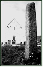
Standing stone The diminutive stone in the townland of Ballytouhymore, near the road, was the only prehistoric monument identified by Westropp.Standing only 1.35 metres in height it is almost rectangular in plan. Paul Gosling remarks, "The erection of large, more or less unhewn stones, often inprominent locations, was a widespread custom in prehistoric Ireland and elsewhere in western Europe. ...single standing stones appear to have been erected over a long period, possibly from the Early Bronze Age (c. 2500BC) to the Iron Age and even later. It has been claimed that some standing stones may have been boundary and route markers and that other were burial monuments and memorials. The location of the one in Ballytouhmore may suggest the former function. Midden A 'kitchen midden' is exposed at the northern end of the bay to the north of the harbour. An arrowhead of chert was recovered from its lower horizon and suggest that the midden was active in the Early Bronze Age (c. 2500-1500BC) Promontory fort There are six promontory
forts located along the coast Houses and hut sites A number of houses and hut sites have been located since 1989, testifying to considerable populations from the early Bronze Age. At Porteen Fuinsh, where the megalithic tomb is located, there seems to be successive use of the same site, including a number of houses. Two areas of huts, numbering six to eight are located on the southern and western slope of the Knockmore (the Big Hill). Their high elevation and relatively exposed position suggests that they were used as booleys,and could be quite recent. Enclosures A number of circular stone enclosures can be found on the island. Two are located in the north east of the island, not far from the woodland. Field wall systems Some extensive areas of field walls, probably Iron Age, are located at the far west of the island near the storm beach of Leicwee as well as below the Lighthouse, and up along the cliffs, north of the Big Hill. Again, at Porteen Fuinsh, the walls can easily be seen going underneath the bog and the lake.
|
 line of the island, though from aerial photography, it is possible to locate
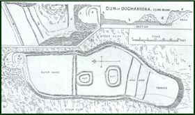
ten. Known through their placenames as "doon"s, these artifical
fortifications may have been used from the Bronze age up until medieval times.
Doonagapul was excavated as part of the New Survey of Clare Island. Westropp
considered it the strongest artifical fortification on the island. Doon Ooghanuisce
occupies perhaps the most dramatic location in Toormore.
line of the island, though from aerial photography, it is possible to locate
ten. Known through their placenames as "doon"s, these artifical
fortifications may have been used from the Bronze age up until medieval times.
Doonagapul was excavated as part of the New Survey of Clare Island. Westropp
considered it the strongest artifical fortification on the island. Doon Ooghanuisce
occupies perhaps the most dramatic location in Toormore.