| 1. Symposia / Historical Safaris
3. Research 4. Surveys
7. Folklore 9. Contact us 11. Links |
19th century and Historical Geography
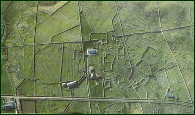
The island's last landlord was Mr. James McDonnell o f Westport, whose neices inherited the island, and sold it to the Congested Districts Board for �5,486 in 1895.In 1897, Charles Browne, MD, conducted an anthropological survey on Clare Island and Inishturk. He expresses great urgency in his documentation.The island had been bought by the Congested Districts Board two years earlier. Through the work of the Board yet another change transformed the island's landscape and way of life. When they took over the management of the island, four fifths of the total area was occupied by 98 tenant farmers, (although only 68 tenancies were recorded on the previous landlord's rental-a consequence of the ruinous practice of subdivision). Rundale, as this type of landapportionment is known, was prevalent throughout the west of Ireland. A man would have as many as thirty different holdings , sometimes as small as an eighth of an acre, scattered throughout the island. In 1892, a preliminary report for the Congested Districts Board was conducted by Major Ruttledge-Fair. He describes the existing conditions and makes recommendations for improvements should the Board acquire the property.The population of the island at the time was 692. He describes the land as being of good quality, and that a superior class of both cattle and sheep are reared here than on any of the other islands. An average holding would have three acres under cultivation in the following way: 1.25 acres under oats, the same amount under potatoes and half an acre in meadow.
When the Board acquired the island it immediately set about re-apportioning or "striping" the island into 77 new farms, separating the tillage from the pasture land with a five-mile-long dry stone wall, known as the Boundary Wall, averaging 5ft6in in height. About fifty miles of lesser walls and mearings were built to mark the boundaries of the newly designated farms, running over existing and in some places ancient lazybed field systems which followed the contours of the land.
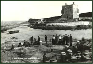
The island assumed a much more orderly appearance. In 1897 there were only five houses into which the cattle and pigs were not taken every night. The Board assumed the function of landlord for the period of re-organization- about four years in all, during which rents were duly paid in full by the tenants. Purchase annuities were introduced, replacing the old system of paying rents, the sums advanced for this purpose repayable over a term of 68.5 years at an interest rate of 3.25%. An important stipulation was the prohibition of subdividing. Entering the twentieth century, Clare Islanders were landowners of their own holdings. The Board instituted a number of "works". In addition to wall-building, islanders worked on road construction and improvements. A fishing industry was established.The famous Lawrence collection photographs show extensive herring barrels at the quay. Girls from as far away as Donegal were employed, in addition to islanders, fish gutting. The herring industry collapsed when the fish failed to return to the area in the mid 1940's.
|
 The Great
Famine of 1846-47, and all the smaller famines, mark a profound point on the island's
timeline. The ubiquitousnous of the lazybed, the abandoned potato ridge as the symbol of
the catastrophic demography of the west of Ireland is perhaps nowhere so profoundly
illustrated as on Clare Island.
The Great
Famine of 1846-47, and all the smaller famines, mark a profound point on the island's
timeline. The ubiquitousnous of the lazybed, the abandoned potato ridge as the symbol of
the catastrophic demography of the west of Ireland is perhaps nowhere so profoundly
illustrated as on Clare Island.