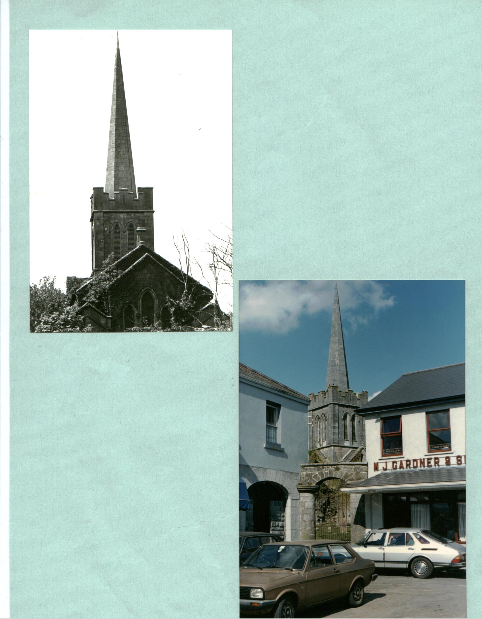
 St Marys Church in Athenry.
On this page we will present you with all the local history of our area, Lisheenkyle and our parish; Athenry. There are many local areas of interest and historical landmarks around the area, especially in and around Athenry itself.
School History
Lisheenkyle National School was first opened in 1951.It started as a one-teacher school and the first teacher was Mrs. Connolly. Gradually, as the area flourished the numbers increased and it became a two-teacher establishment. Presently it’s a four-teacher school and our beautiful new extension was opened in 1991. The Dept. of Education has now sanctioned a further extension, which we hope will be completed within two years.
St Marys Church in Athenry.
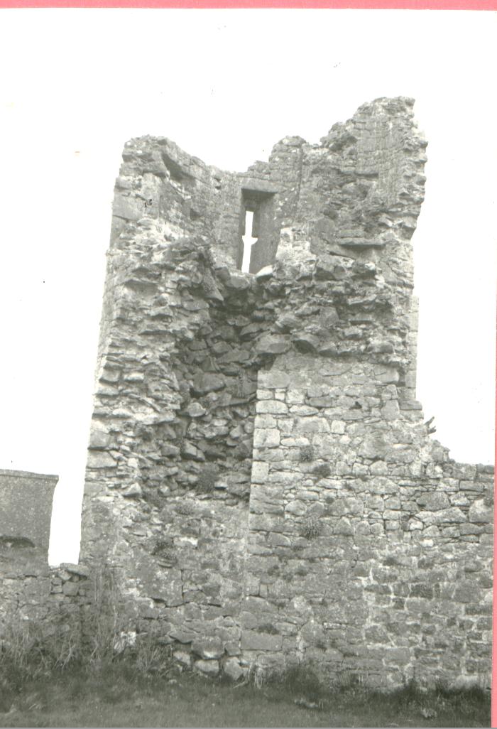
The Normans founded Athenry because they saw the advantage of its central position and the ford on its river. It is historically connected with Bermingham in England. In 1235, William de Burgo, the Norman lord, gave Peter de Bermingham possession of lands Around Athenry.
Henry III summoned Peter to parliament as a baron, as he was the first lord of Athenry. The little of Baroney of Athenry became dormant between the years 1797 and 1802.
Athenry-town of the ford of the kings
Athenry takes its name from its situation at the function of three ancient kingdoms, where the corners of Hy-many O Kelly, Hy-briuin Seolo O Flaherty, and Hy-feachrach O’ Hynes touched at the ford. Many tourist attractions include the castle, The Abbey; the arch, the old church, Lady’s well, the old walls and market cross.
By Sharon & Louise.
The Dominic Abbey
The Abbey of St. Peter and Paul was founded by Meyler de Bermingham in 1214. In the year 1243, it was destreyed by fire, and again in 1574. In 1644 it was re-built to be used as a university. During Cromwells invasion in 1649 the abbey was used to stable the soldiers horses, resulting in its destruction. With the introduction of the penal laws the monks were forced to flee to Belgium and live as out laws. Some of these later returned to start a school in ester, however it is generally believed that they never re-established themselves in Ireland after the penal laws. The main window of the Abbey is still intact, and its design is used as a school crest for Presentation College Athenry.
By Katie and Maedhbh.
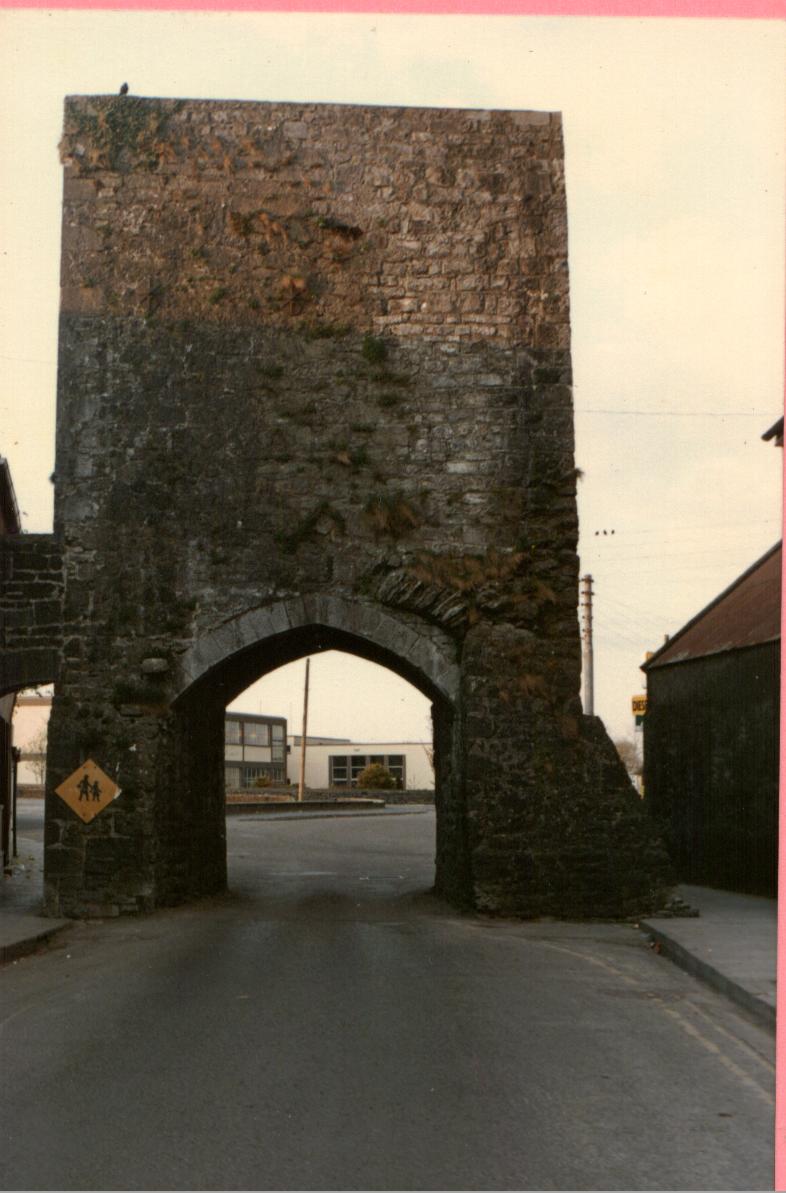
The North Gate.
The market cross
The market cross is proudly seated at the centre of the Square in Athenry.
It is said to be over 500 years old.
It is beautifully designed with a carving of Christ as he is crucified on one side and Mary and child on the other.
At the base there are carvings of animals and it bears a resemblance to Celtic crosses.
The cross when touched was said to seal bargains.
It was moved to its present position from Parsans green in 1629 when
permission was given to hold markets in the town.
The man responsible for its creation was named Coyle.
Jolouise and Aoife
The mace and seal.
The mace is singular design a clenched first cupped below the wrist made from solid bronze and mounted on a stout ashen handle. It wars about 7 inches in length.
The seal the design on this was of a castle with two heads on spires arising from the battlements.
The mace seal were in the keeping of John Blakeney of Abbert, a patron of the borough of Athenry and were presented to the newly opened Athenry Heritage Centre this year.
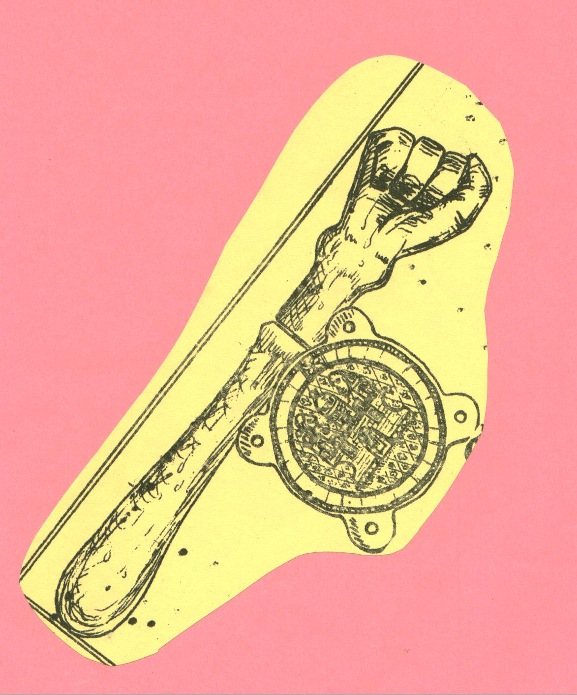 The Mace and Seal.
By Lisa and Neil.
LADY’S WELL
The battle of 1249, between the Irish and the Normans was said to have been lost by the Irish because they attacked on the feast of the Assumption. Because of this the Irish did a pilgrimage to the well every Assumption day. Lady’s well is located near Esker monastery. By Gary Murphy.
Athenry Millennium
Flag
When one considers that a flag is often viewed from a distance of a hundred metres or more, and that it’s usually fluttering in the wind, the main ‘rule of thumb’ in a designer’s mind is ‘keep it simple’! One could create a beautiful kaleidoscope of colour, with intricate detail, but at hundred metres it would look like a multi-coloured blob.
The Athenry Millennium flag, sponsored by Athenry Credit Union, suggests the arrival of the year 2000 in Athenry, as many thousands of visitors have done in the past, under the North Gate (The arch) . The colours represent light coming out of darkness. The background colour suggests the darkened sky during the last solar eclipse of this Millennium, while the gold shows the colour of the sun coming out and also the dawn of the morning of the birth of Jesus Christ 2000 years ago.
Some people have asked why not use the Athenry colours? Maroon and white are indeed the Athenry GAA club colours, but this flag is for everyone and I’ve never seen a maroon sky! On the other hand,a blue sky with yellow lettering might be interpreted as representing our neighbours Clare or Roscommon! Anyway, its not possible to please all the people all of the time so this is it and I hope that it makes a suitable momento of the arrival of 2000, which we shouldn’t forget is the 2000th anniversary of the birth of the saviour.
Thomas and Gary.
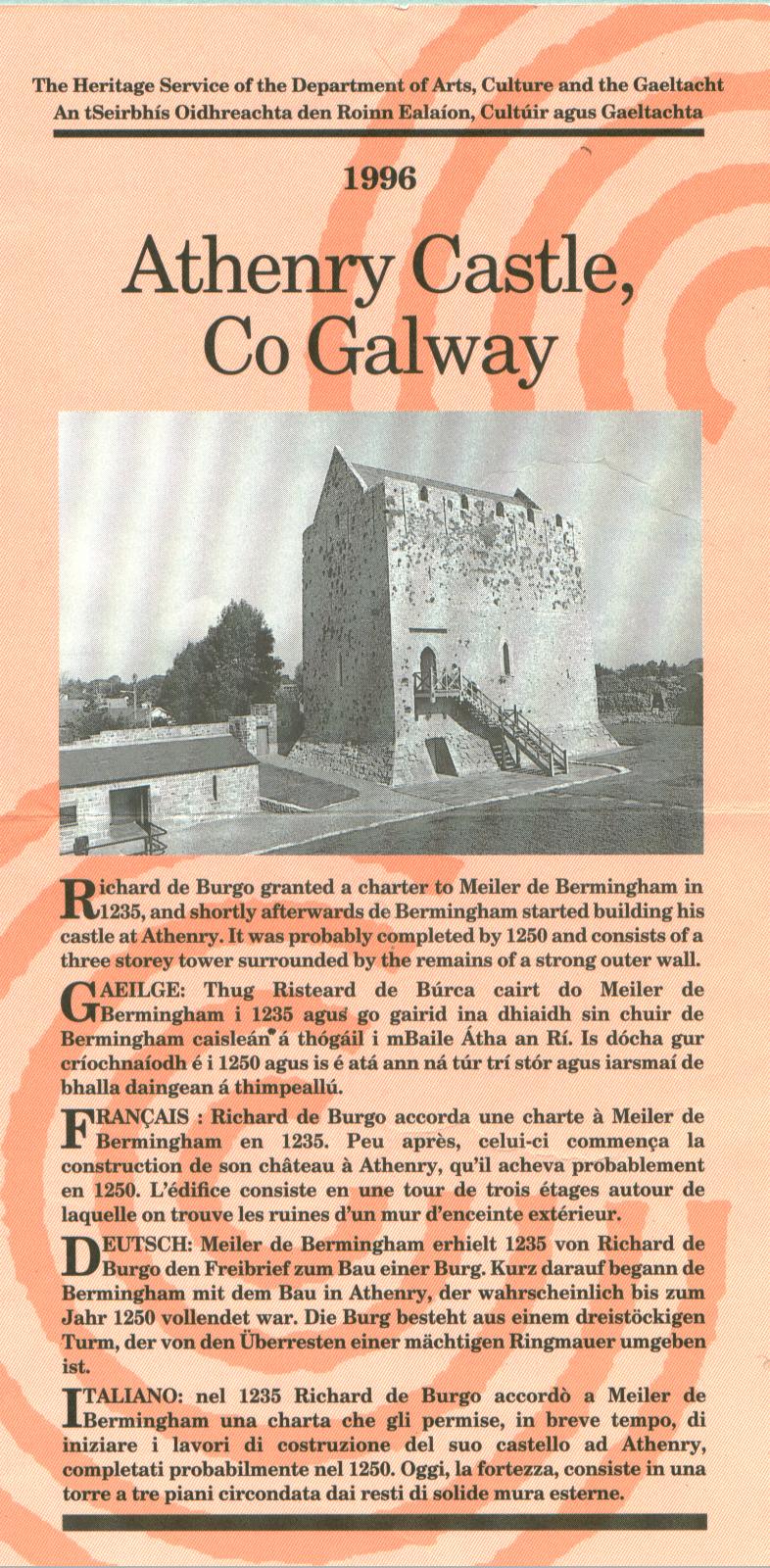
KING JOHN’S CASTLE
King John’s castle is the earliest remaining building in the town.
It was built at the ford by Meyler de Birmingham, shortly before 1240.athenry castle is one of the finest 13th century castles remaining in Ireland. It consists of a three storied keep, within gables added to its top during the late 15th to early 16th century, surrounded by a strong curtain wall. Which had two corner towers and a corner butress. This was near the gate, as the keep over looking. The curtain walls obliviated the necessity of defensive towers there. The castle has recently been renovated and opened to the public. It contains an audio-visual display and a guided tour is available.
THE GREAT FAMINE
Between the 1800 and1850 there were poor people everywhere in Europe. In Ireland many people lived close to starvation all the time. A poor family in a town or city might live in a over crowded tenement room or in a damp basement; in the country home might be a one-roomed hut with out window or chimney. Foreign travellers wrote about the extreme poverty that they saw among the Irish and the number of beggars that they met every where.
THE DIVISION OF LAND
The population of Ireland increased rapidly during this time .In 1800 there were 5million people by 1840 there were over 8 million. Most of these people lived on the land and depended on farming for a living. Whereas a farmer now a days will usually pass on his land to only one of his sons, in the 1820s
And ‘30s he divided it among all of them. As a result farms became smaller and smaller and more and more people began to depend on one food for survival – the potato. They grew potatoes wherever they could – on the edges of bogs and even on the side of a steep hill. They ate potatoes for their breakfast, dinner and supper.
GOVERNMENT WORRY
This was a very dangerous situation, for if there was a crop failure many would die of hunger. Indeed, in 1817, and again in 1821 there were bad harvests, and people died of starvation, especially along the West Coast. The government in an attempt to improve matters introduced a ‘poor law’ to combat poverty. Landlords and strong farmers had to pay a tax (called rates) and this money was used to build large workhouses in the towns where those who had no money or food could go and live. The workhouses were harsh and unpleasant places where families were split up and men and women were kept apart. Not surprisingly, very few wished to enter the ‘poor house’.
THE ‘QUAKERS’
There was once this family in Athenry they were known as the Quakers during the famine. They were a helpful family and they used to send out food to the poor and starving.
The Town Walls.
![]() E-mail us lisheenkyle@hotmail.com
E-mail us lisheenkyle@hotmail.com