

| |
|
|
|
|
|
|
|
|
|
|
| |
|
|
|
|
|
|
|
|
|
|
|
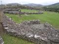
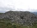
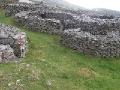
This is an inland promontory fort likely dating from the Iron Age. Known locally as Binn na Port the mountain has no definitive name and names for the site include Benagh after the area, Binn Fhaiche and Slieve Bronach. It is relatively recently that the site was confirmed as a Promontory Fort by the late Barry Raftery in 1984 after its rediscovery by Steve MacDonogh. The fort is spectacularly sited dominating much of the surrounding landscape. Over 2600 feet (800m) above sea level on an arete a little over 12 m wide with cliffs on its northern and southern sides. The arete eventually narrows and drops steeply on its western side. It has been described as like the prow of an upturned boat. The pilgrim path to Mt Brandon starting at Faha skirts across the lower slope of the ridge leading to the top of Binn na Port. Not much more than a couple of hundred metres up above the pilgrim path is a low wall. None of the descriptions I have seen mention this wall which may be some sort of boundary linked to the main surviving structures higher on the ridge. Higher on the approach ridge to the top of Binn na Port the main fort consists of two large stone wall which run the width of the promontory. The outer wall is over 100 metres long. It is best preserved on the southern side of the approach ridge overlooked by Mt Brandon with a glacial valley below. The wall consists mainly of large sand stone blocks and is over 2m high and a metre thick with a slight batter. What is likely to have been the entrance is still visible. Much of the middle section of the wall has collapsed over time but a spread of Sandstone blocks across the hillside marks its position. On the northern side of the ridge some of the wall survives but not to the same height. Approximately 120m west of this outer wall towards the summit lies the second wall about 30m north south. Outside this wall there is a dip in the ridge before it slopes up again to the wall. This could be natural but there is a possibility that it is a fosse forming part of the defenses. Outside the wall another possible defensive feature are sharp slabs of upstanding rock which does not look natural. The wall has an entrance and at its highest is over 2 metres high and over 2 metres thick. When you pass through the entrance the summit rises gently before you. There are no visible earth works within and it is likely the peat cover is fairly thin. Some possible terraces can be identified. However if there were structures here during its use they must have been of wooden construction. From the mountain top there are commanding views of much of the surrounding countryside in all directions. Barry Raftery has pointed out that the effort and time in constructing such a hill fort would have been considerable requiring large numbers of people over an extended period of time. Even today in certain conditions the walls of Binn na Port are visible from much of the surrounding county side. So the fort whether a military or a ritual site, would have been a prominent feature of the landscape and a major statement of the power and status of its builders. Certainly in our current climate it is difficult to envisage Binn na Port being occupied during the winter months. Possibly the site was only used during the warmer months of the year. Also on the Dingle peninsula inland from Binn na Port is a second inland promontory fort, Caherconree at 630m above sea level in the Slieve Mish mountains
Bibliography
|
Site VisitMy visit to Binn na Port was made in late May 2011. | |||
 |
 |
 |
 |
 |
 |
 |
 |
 |
 |
 |
 |
 |
 |
 |
 |
 |
 |
 |
 |
 |
 |
 |
 |
 |
 |
 |
 |
 |
 |
 |
 |
Site Location
(www.archaeology.ie) |

|
| Next > |
|---|
