|
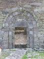
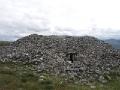
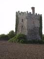
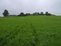
Slieve Gullion Passage tomb is located on the southern end of the summit ridge of Slieve Gullion. At 573m and situated just west of the Cooley peninsula Slieve Gullion provides extensive views over much of the country. To the south the Dublin and Wicklow mountains are visible and the central plain of the midlands to the southwest. Visible to the North are the Belfast Mountains and Slemish mountain and Lough Neagh. To the west, in very clear weather some of the Donegal mountains are visible. To the East are the Mourne Mountains and the Cooleys. Its geographical location was probably a significant factor in selecting it as a site for a Passage Tomb. Slieve Gullion Passage Tomb is the highest surviving passage tomb in Ireland.
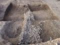
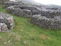
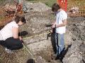
The stone cairn of the passage tomb rises above the blanket bog which covers most of the summit. Of the tomb itself, some of the entrance passage and its lintel roof survives as does the central cruciform chamber, though with much of the corbelled roof gone. The tomb was excavated in 1961 by Queen's University. Three basin stones were identified all natural stones, improved slightly by hammer dressing. Finds were limited to some fragments of cremated bone and seven pieces of worked flint which included a scraper and barbed and tanged arrowhead. The excavation also identified the kerb stones surrounding the tomb which were under the blanket bog. A cairn on the northern end of the summit ridge contained the remains of two Bronze Age cists. Some pollen analysis and radiocarbon dating was carried out on samples taken at the margin of the Passage Tomb cairn. The Pollen analysis showed a major elm decline, with signs of woodland clearance dated to c. 2000 bc. The appearance of small stones in the deposit may relate to the building of the cairn. These stones appear in the profile between samples dated to c. 3300 and 2000 bc.
|