| 1. Symposia / Historical Safaris
3. Research 4. Surveys
7. Folklore 9. Contact us 11. Links |
Botany of Clare Island
1. Vegetation Map
Praeger's vegetation map is a record of the vegetational position of the island in 1911. Analysis of the map shows 49% of the total area to be Calluna or heather formation. Farmland makes up 36%, natural grassland on the cliffs 11%, calluna- eriopharum-juncus 3%, with woodland, alpine, saltmarsh, plantago sward each accounting for less than 1% of the total area. Praeger's report noted the change from tillage to pastoral farming, and that the heather was being slowly grazed away. As to species composition he listed 413 species , though about 150 of them were not abundant. Many of these were only located once,and infrequently 2/3 times over the Island. It is these species that have proved difficult to relocate. In 1986 the flora of the island was resurveyed. 307 of Praeger's 413 species were found, plus 22 additional species not listed by Praeger. The general reduction in species number (25%) reflects a fundamental change in the island's vegetation, resulting from changed agricultural practice with a major shift from arable farming to sheep grazing. The consequent change in flora was especially noticeable in the reduction of weed species associated both with grain and root crops. Such weeds as wild radish, pearlwort spurrey, scarlet pimpernel and common comfrey were absent.Field gentian was also absent though it was listed as a frequent occurrence by Praeger. Among the 22 new species are bulbous buttercup, lessers winecress, sea rocket, marshmallow, wild conteaster, cranberry (a species with a very restricted distribution in West Mayo) and wild celery. During the intervening years grazing has altered the botanical composition in terms of community structure; and to some degree species composition (though it is a combination of effects that influences this). Since then many new species have been added to the species list for the Island, so that the number of species is now only slightly lower than Praeger's figure. Undoubtedly the dynamic of the Island's vegetation will see fluctuation's in species number, and further introductions. Current work on the flora of the island carried out by Tim Ryle, Department of Botany, University college Dublin for the New Survey has concluded:
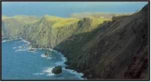
Natural grassland- refers to areas of grassland in commonage areas, that are similar to grasslands found in farmland areas. Most are found in coastal areas and are dry in nature. Some of the inland examples may represent dry areas from ancient farming settlements long since abandoned before the congested districts board built the wall. Calluna formation- this community covered most of the Island (commonage) and has been replaced with a mosaic of upland vegetation communities dominated by rough hill grazings typical of the West of Ireland. This would also include small areas of bracken, bogs, flush, lakes, small stream valleys and some areas of heather. The grassland range from wet to dry depending on the depth of soil and slope but are dominated by Bent grass (Agrostis capillaris) and Sheep's fescue (Festuca ovina) with a variety of rushes (Juncus sp.) and mosses in wetter areas. The other dramatic change in the vegetation since Praeger's time is the extent of overgrazing by sheep on the common land. This phenomenon is by no means unique to Clare Island. Large areas of mountain commonage throughout the west of Ireland have been so affected. This problem is only now being seriously addressed by Dublin and Brussels through the Rural Environmental Protection Scheme(REPS). "On Clare Island, no portion of the vegetation can be claimed as absolutely undisturbed except that occupying certain portions of the sea-cliffs where the ubiquitous sheep are unable to climb. Nevertheless the heath area which occupies about 2/3 of the island is still comparatively in its primitive condition." Clare Island Survey Today the heath is so closely cropped that in many areas it has disappeared completely. The most dramatic example is that of the Southern slope of Croaghmore. Praeger described heather "up to three feet in height". Today the slope is smooth, almost completely barren of heather.
|

 - The 1200ft. path
has eroded away and access to the cliffs was impeded. Some of the species have not been
relocated. It is impossible to say what is the cause-- other research would indicate that
grazing is not a contributing factor.
- The 1200ft. path
has eroded away and access to the cliffs was impeded. Some of the species have not been
relocated. It is impossible to say what is the cause-- other research would indicate that
grazing is not a contributing factor.