| 1. Symposia / Historical Safaris
3. Research 4. Surveys
7. Folklore 9. Contact us 11. Links |
Geology, soils & Paleobotany
In what follows, we borrow heavily from a 'layman's' account of the geology written for us by Professor Adrian Philips1. 1. Leic and Ballytoughey Formations
Geologically, the island can be divided into three sections, each of which have been formed at different periods of time. Nature has drawn a line from the steep cliffs on the north side of the Big Hill to the sandy beach by the harbour. From sea, or from the mainland, this line is quite visible. The fault which forms the cliffs on the mountain is carried through the island. At the foot of the inland cliffs is a road known as the 'Leic Road'. The visitor who passes by the great cliff-face at Leic is traversing one of the major fault systems of Ireland. The Leic Fault can be traced north eastwards through Donegal to the Great Glen Fault system of Scotland. Vertical movement on this fault produced the dramatic cliff face at Leic where one section of the Earth's crust was pushed upwards relative to the other, while horizontal movement brought ancient rocks to the northern part of the island from 160 kilometers away to the northeast.
Geological Map of the Ballytoughey Formation:
These rocks form a link to the remote past. It is not, however, a lifeless past. Hidden in the rocks of Clare Island is also a record of past life.The oldest fossil animal ever found in Ireland comes from the beds of chertin the townland of Ballytoughey More in the northern quarter of Clare Island. It is the fossil of a sponge probably 540 million years old. More recently, another fossil of slightly younger age was found in 1997 by Dr. John Graham.
South of the Leic Fault, the rocks are considerably younger than the folded crevices in Ballytoughey and almost half the age of the low rock ridge between Kill and Portariff. The sedimentary rocks south of Leic were laid down along the southern coast of the North American continent. At this time the southeast portion of Ireland was attached to the European continent and a major ocean lay between it and the part of Ireland that was attached to the American continent. Above this second layer of rocks lies a third, up to 300 metres in thickness, of interbedded red and green siltstones, sandstones and beds of volcanic ash.These rocks contain numerous traces of evidence of deposition in very shallow water. The main bulk of the Big Hill is formed by a major unit of sandstones, best seen at the west end of the island around the ruins of the old Signal Tower at Toormore. Along the steep cliffs on the west side, several horizons of calcareous siltstones provide a limey soil. It is here that the rare alpine flora find their unique island habitat. |
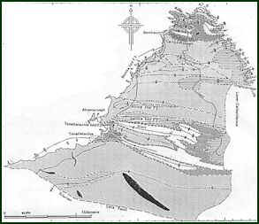
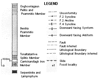
 Younger microfossils, some 470 million years
old, have been found in younger layers of this same succession of rocks, known as the
Ballytoughey Formation. These rocks are best seen near the lighthouse and along the
northwestern cliffs of the island. Therocks of the Ballytoughey Formation were folded and
refolded at least four times during major earth movements 460 million years ago.
Younger microfossils, some 470 million years
old, have been found in younger layers of this same succession of rocks, known as the
Ballytoughey Formation. These rocks are best seen near the lighthouse and along the
northwestern cliffs of the island. Therocks of the Ballytoughey Formation were folded and
refolded at least four times during major earth movements 460 million years ago.