|
|
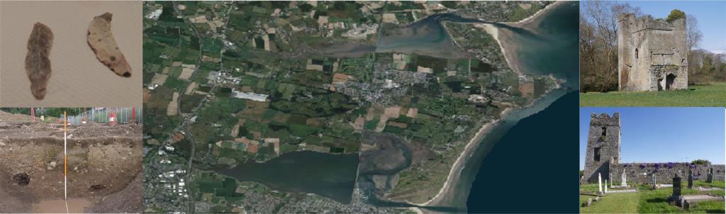
With the collapse of the Roman Empire in the 5th Century AD there was increased raiding the western coast of Britain by Irish pirates. Maritime connections were also to lead to the introduction of Christianity to Ireland and the beginnings of Early Christian Ireland or the early medieval period dated to around 500AD (O'Sullivan and Breen 2007,109). The Early Medieval Archaeology Project (EMAP) describes this as one of the most significant periods of social, ideological, environmental and economic change in Ireland (O'Sullivan et al. 2008,1). The EMAP report (O'Sullivan et al. 2008) on excavated sites relating to this period provides a useful frame work for interpreting the early medieval sites on the Donabate-Portrane peninsula. It is a period for which we have considerably more surviving evidence on the peninsula then for prehistory. The Early Medieval in Ireland which was to last until the arrival on the Normans in the 12th century is the first period for which some historic information is available to complement the archaeology and support our interpretation. As with previous change, the transition from the Iron Age to the Early Medieval is likely to have been a gradual process with changes in beliefs and the economy evolving over time. The Annals tell us that North Co. Dublin, at the dawn of the historical period (5th/6th centuries A.D.), formed part of the geographical region of Brega(Courtney and Goucher, 2007) . The excavated site at Coldwinters may have transcended the late Iron Age / Early Christian period. The burial practice at the site is potentially an example of this transition as the burials could reflect a Pagan or Christian burial tradition, being all extended supine inhumations aligned east-west (Opie 2002, 44) . The last burial at the Coldwinters site was located in the centre of a small circular ring ditch measuring c. 10m in diameter constructed within the main enclosure. This burial consisted of a single human extended supine burial contained within a slab lined grave and covered by a few covering lintels and was aligned southeast/northwest. With evidence of settlement activity also present, Coldwinters could represent a settlement/cemetery, a site where prehistoric funerary monuments and ancestral palaces continued to remain foci for burial and subsequent settlement activity in the Early Medieval period (O'Sullivan et al 2008). On the nearby Bellinstown site the north eastern side of the Iron Age ringbarrow as described in the previous section was cut by five unprotected east west inhumation burials. Immediately beside these inhumations were four other burials, orientated northeast southwest. This mix of burial practices could also represent a gradual transition from pagan to Christian burial practices, and continued use of a prehistoric burial site in the early medieval period. (O'Sullivan et al 2008). On the peninsula proper no burials from the Early Medieval period have been uncovered to date. Evidence both archaeological and historical though does exist of Early Medieval activity on the peninsula. The primary settlement evidence on the peninsula for this period consists of several possible ringfort sites, the predominant settlement type surviving from this period. Ringforts consist of a circular area surrounded by one or more earthen banks and outer fosses (Mulligan, 2005). The current consensus from assessment of those ringforts excavated to date supported by historical sources is that the majority of univallate ringfort sites can be interpreted as the farmsteads of small farmers engaged in pastoral agriculture. Multivallate ringforts are associated with high status sites(O'Sullivan et al 2008). The possible ringfort sites on the peninsula have been recorded as enclosures and were mostly detected by aerial photography as circular cropmarks. No visible trace survives at ground level at the sites identified. It is likely that they represent ploughed out ringforts and occur at Lanestown (SMR DU012-006), Kilcrea (SMR DU012-017), Turvey (SMR DU008-025) and at Lissenhall Great where an enclosure (SMR DU012-003) and an earthwork site marked as 'site of fort' on the OS 1st edition (SMR DU012-015) is located (Courtney and Goucher, 2007, 11).
The site at Kilcrea (SMR DU012-017) is also marked on the first edition Ordnance Survey map. Satellite imagery also shows the main enclosure with some ditches outside. It is likely that there were other ringforts on the peninsula and the townland names of Rahillion and Ballalease may be indicative of previous ringforts (Courtney and Goucher, 2007). In the townland of near Raheen Point (SMR DU008-026)earth banks shown on the first edition Ordnance Survey map which survived to the late 20th century beside the Rogerstown estuary surrounded a low marshy are which may have served as a harbour but this feature has not been dated. The Early Medieval period saw the development of major ecclesiastical sites in Swords and Lusk. The foundation of the monastic site at Lusk Whilst not on the same scale as Lusk or Swords, several of the ecclesiastical sites on the Donabate-Portrane peninsula have been dated though historical sources to the Early Medieval period. These include St Mochuda's Church at the Burrow known as The Chapel Bank (DU008-028), St. Canice's at Portrane (DU008- 03101) and the churches at Ballymadrough (DU012-01301) and Kilcrea (DU012-01601).These church sites probably received direction from the major ecclesiastical centres located at Swords and Lusk (Courtney and Goucher, 2007). In addition to these four sites Bates (2003) also mentions St Colman's in Lanestown and St. Kenny's on the coast as the six celtic churches on the peninsula. Very little archaeological investigation has been carried out at these sites. We do not know if these sites were ecclesiastical settlements as defined by Swan (1983). The site at St Mochudas is enclosed by a low bank but this has not been dated though historical sources suggest that St Mochudas was a chapelry of Lusk monastery (Bates 2003). Churches and structures from the sixth to ninth century would have been predominantly built of wood. Mortared ecclesiastical structures only became common from after the 10th century A.D. (O'Sullivan et al 2008). The church at Donabate was thought to be medieval in date. However recent excavations of a section of the Glebe field in 2008 below the site of the current 18th century church and grave yard uncovered evidence of Early Medieval settlement. A U-shaped linear ditch 99m in length orientated, east-west was uncovered in the excavation, truncated at either end by the adjoining road We have no evidence for the nature of the Early Medieval economy on the peninsula. It is reasonable to assume as supported by historical sources and archaeological evidence from sites though out the country that agriculture was the dominant activity as evidenced by the probable ringfort sites in the area. Up to 800AD Lambay Island may have served as a trading emporia similar to Dalkey Island. Imported B ware pottery was found in burials excavated on the island (Doyle, 1998). A feature of this period is the development of water mills and milling. In Donabate in Kilcrea townland at Baltray are the remains of a tidal mill which historic sources suggest dates at least to the medieval period ( O Conbhui, 1963). The late 8th Century saw the first Viking raids on Ireland. The monastery on Lambay island may have been plundered in 795 as the annals make reference to a raid on Rechru the pre-viking name for Lambay which is a name with Viking origins. Though the annals could be refering to Rathlin island also known as Rechru. It is possible there was some Viking settlement on the peninsula but there has been no archaeological evidence uncovered to date. By the middle of the ninth century bases were established by the Vikings at Inbher Domhnainn (Malahide) and Ben Eadair (Howth) (Courtney and Goucher, 2007). Bates (2001) mentions Knockaman, as the highest point in Burrow townland, as the site of a battle, which based on artefacts recovered in the 19th century involved the Norse. We have no evidence for the nature of the Early Medieval economy on the peninsula. It is reasonable to assume as supported by historical sources and archaeological evidence from sites through out the country that agriculture was the dominant activity as evidenced by the probable ringfort sites in the area. Up to 800AD Lambay Island may have served as a trading emporia similar to Dalkey Island. Imported B ware pottery was found in burials excavated on the island (Doyle, 1998). A feature of this period is the development of water mills and milling. In Donabate in Kilcrea townland at Baltray are the remains of a tidal mill which historic sources suggest dates at least to the medieval period (O Conbhui, 1963). |
BibliographySpecial thanks to Margaret Gowen & Co. Ltd, NRA and IAC for facilitating access to unpublished excavation and archaeological assessment reports.
|
| Last Updated , Jan 2015 |
| Next > |
|---|
")

