|
|
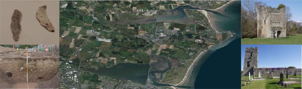
The arrival of the Anglo-Normans in Ireland in 1169 marks the start of the Late Medieval period. By the winter of 1171-2 the areas around Dublin were brought under Norman control. In 1183, Comyn, Archbishop of Dublin, established his archiepiscopal manor at Swords and a large portion of Donabate/Portrane came under his control (Kananagh 2009,5). To consolidate their hold on the land the Normans constructed mottes. These were wooden castles built on a large earthwork and sometime with an outer enclosure called a bailey (Mulligan 2005). A possible Motte site at Ballymadrough identified by the archaeological survey (SMR DU012-014) and marked on the first edition OS maps as a mound could be evidence of the early Norman settlement on the peninsula. Research by the Discovery program on the medieval manor of Forth at Castlemore Co Wexford shows an earthen motte and its ruined bailey surviving several hundred meters from a denuded graveyard. In Ballymadrough the site of this mound is almost 1km from the church and graveyard site. In 1230 historic sources make reference to the medieval church in Donabate when it was granted to the monastery of Grane, County Carlow. In 1240, the parish was administered by Richard De St. Martin. In 1310, the king, during the vacancy of the See of Dublin, presented William de Bathe to the vicarage of Donabate. He was succeeded, as far as the records show, by Thomas Athaland in 1375, and by Henry Marleburgh in 1419 (Courtney and Goucher 2007,12). The site of the medieval church in Donabate is occupied by the current church built in the 18th century (Courtney and Goucher 2007). An excavation carried out in 2008 in advance of road widening, below the ridge where the current church and surviving Tower House are sited has given us an insight into the area surrounding the church during the medieval period. The excavation uncovered a portion of a large rectangular structure (Plate 15), possibly a house. Several sherds of late 12th to mid 14th century pottery were found in the external walls. A possible internal partition wall and some and some remains of the internal stone floor also survived (Kavanagh 2009). A large rubbish pit was found 2m from the building remains and contained more sherds of late 12th to mid 14th century pottery, iron nails and animal bone. Pottery of this date was also found in the fills of several north south ditches discovered on the site. Over 300 sherds of medieval pottery were recovered from the site consisting mostly of Irish local wares but some 13th and 14th C Saintonge ware from France was also found along with some pottery sherds from the Iberian peninsula. Saintonge wares were by products of the extensive wine trade of the time with the Bordeaux area of France. The medieval finds from this site as fairly typical of a medieval farm site of this period. Certainly the pottery found at the site at Cookstown near Ashbourne was a similar assemblage (Clutterbuck 2009). The Turvey avenue excavation gives us an insight into life in Medieval Donabate. This building was demolished at some stage as the excavation indicated that its walls were truncated by several later medieval features including a small corn drying kiln (Kavanagh 2009). Carbonised seeds recovered from the kiln included oats, wheat and barley which were likely to have been grown in the area. Further evidence for medieval settlement comes from excavations in a nearby site in Beaverstown where sherds of Dublin ware pottery were recovered from a pits and a possible field boundary (Lohan 2004). In the archaeological assessment carried out on the Balllinmastone lands (Frazer and Eriksson 2008) a base sherd of handmade pottery (possibly Leinster Cooking-type Ware) was found in a test trench across an enclosure ditch. In the townland of Corballis the first edition Ordnance Survey map records a moated site (Figure 18). It is possible that this could this be an Anglo-Norman medieval moated farm site. No remnants of the feature are visible today. A possible moated site at Newtowncorduff (SMR DU008 -016) is recorded just north-west of the peninsula and a moated site is also recorded on Lambay island (SMR DU009-001006) (Sites and Monuments Database). Warfare was endemic in fourteenth century Ireland and it was during this period that the first tower houses were built (O'Keefe 1992, 65). There are three surviving tower houses on the peninsula at Portrane (DU008-030), Lanestown Castle at Newbridge Demesne (DU012-004) and at Donabate (DU012-005/02). O'Keefe (1992, 66) describes the Tower Houses of the Dublin region as mainly defended farms houses, rural fortifications, or defended priests houses. For the Tower Houses at Portrane( The Ordnance Survey first edition map marks the ruins of St. Kenny's well and chapel (Figure 14) (SMR DU012-9001) along the coast between Portrane and Balcarrick beach. Now the grounds of St Ita's hospital there is no surface trace of the ruins. At the church site in Kilcrea (Plate 21) the east gable and side walls (Plates 22 and 23) of a single chambered chapel survive. This structure could be medieval in date but has not been dated in any of the literature consulted. It is described in the Site and Monument Record (DU012-016001) as a plain rectangular building roughly built of blocks of limestone and conglomerate. It has splayed single light windows in the east gable and the south wall in which the door rebate survives. O'Conbhui (1963) in his study on the lands of St Marys Abbey mentions that the Cistercians held land in Kilcrea being granted to St. Mary's Abbey, Dublin, by Gilbert de Nugent who became Baron of Delvin in Westmeath under Hugh de Lacy, and held lands in Meath and Dublin. A later charter thought to date from the 13th Century states that Kylcrach was situated near Duuenachbat (now Donabate).and that the monks had mills in Kylcrach. The mills were still on the land at the time of the dissolution of the monasteries, being described in the extent of 1540 as "two watermills." These mills could be the tidal mill in Kilcrea shown as Baltray corn mills on Roques 1760 map of County Dublin (Figure 20). McErlean and Crothers (2008) make reference to the 'North Co Dublin group of tidal mills comprising of known mills that exploited the tides in constricted shallow inlets off the Irish Sea. They are Newhaggard td near Rush , Baltray corn mill in Kilcrea td near Donabate, Burrow td near Portmarnock and Yellow walls townland at Malahide. Today the probable site of the mill is marked by a cairn of stones and the stone wall of the north side of the mill race (DU012-018). In 1466 following the conviction of the Earl of Ormond on treason Edward the 4th granted the manor of Turvey to the Fitzgerald family (Kavanagh 2009). A late medieval find in the national museum, a whale bone book cover recorded as being found in Donabate bears the coat of arms of the Fitzgerald Earls of Desmond. (Wallace & O'Floinn 2002). The lands were restored to the Earl of Ormond in 1507 (Kavanagh 200.9) At the dissolution of the monasteries in 1541, their land holdings on the peninsula were seized. D'Alton (1838) refers to Egidia Wale, "the last prioress of Grane, (Grace Dieu) was found to have been seized of the rectories of Donabate, Kilmacud, and Bray, which, with their tithes and emoluments, were, as the inquisition states, appropriated to said house". Thus began the transition to what archaeologists call the Post Medieval period. |
BibliographySpecial thanks to Margaret Gowen & Co. Ltd, NRA and IAC for facilitating access to unpublished excavation and archaeological assessment reports.
|
| Next > |
|---|
 )and Lanestown (
 ), Moylan(1960 ) reproduces the detailed descriptions of their interior features recorded in the Irish Builder in the late 19th C. The three towers houses have a projecting tower a feature found in many of the Tower Houses of the pale (O'Keefe 1992, 69). Roques 1760 map shows houses in the vicinity of the tower houses and it is likely that this was also the case in the medieval period (Figure 20). All three surviving tower houses also had religious sites nearby. In the case of Lanestown castle, St Colman's church of which there are no visible remains today was located nearby (Bates 2001). Adjacent to the tower-house in Donabate (Plate 18) is the current St Patricks Church of Ireland was built in 1758 on the site of the medieval church which was then in ruins (D'Alton 1838). The current church south porch entrance (Plate 19) incorporates a medieval doorway with a pointed arch of chamfered limestone (SMR DU12-005001).
In Portrane a short distance from the tower house known locally as Stella's tower, is St Catherines Church (Plate 20), though the surviving structure may be late medieval in date (SMR DU008-031001). The remnants of a fourth Tower House (DU008-024001 was discovered during the demolition of Turvey house in the 1980s. The Tower House had been extened in the late 16th century house and incorporated into the 18th century Turvey house.
), Moylan(1960 ) reproduces the detailed descriptions of their interior features recorded in the Irish Builder in the late 19th C. The three towers houses have a projecting tower a feature found in many of the Tower Houses of the pale (O'Keefe 1992, 69). Roques 1760 map shows houses in the vicinity of the tower houses and it is likely that this was also the case in the medieval period (Figure 20). All three surviving tower houses also had religious sites nearby. In the case of Lanestown castle, St Colman's church of which there are no visible remains today was located nearby (Bates 2001). Adjacent to the tower-house in Donabate (Plate 18) is the current St Patricks Church of Ireland was built in 1758 on the site of the medieval church which was then in ruins (D'Alton 1838). The current church south porch entrance (Plate 19) incorporates a medieval doorway with a pointed arch of chamfered limestone (SMR DU12-005001).
In Portrane a short distance from the tower house known locally as Stella's tower, is St Catherines Church (Plate 20), though the surviving structure may be late medieval in date (SMR DU008-031001). The remnants of a fourth Tower House (DU008-024001 was discovered during the demolition of Turvey house in the 1980s. The Tower House had been extened in the late 16th century house and incorporated into the 18th century Turvey house.