Archaeology of the Donabate Portrane Peninsula
Archaeology of the Donabate Portrane Peninsula |
|
The Archaeology of the Donabate Portrane Peninsula |
|
Ā
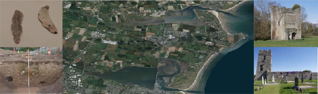
DonabateThe Donabate- Portrane peninsula is located along the coast of North County Dublin. The peninsula shaped not unlike the head of a hammer, is bounded to the north by the Rogerstown Estuary, the Irish Sea to the east and Malahide Estuary and the Broadmeadows estuary to the south. On the landward side it is bounded by the old N1 road and the new M1 motorway. The peninsula occupies an area of 32.7 Sq Km and is a relatively low lying undulating semi rural landscape with several low east west orientated ridges. The sea facing head of the peninsula consists of the spit beaches of Portrane and Donabate (Balcarrick) separated by a coastal cliff formation with Lambay island lying offshore. From much of the southern side of the peninsula the Dublin Mountains can be seen in the distance. The agricultural land on the penisula consists of predominant grey brown podzolics with associated gleys, over a parent material of till with limestone and shale, soil types that are naturally fertile.The peninsula is still largely a semi rural area with tillage the predominant agricultural activity. Significant land is also devoted to leisure activities including six golf courses and public parks on the old demesne of Newbridge and part of the Turvey estate. Portrane demesne is now the site of St Ita's hospital built in 1896. Since the year 2000 significant development, mainly housing, has taken place on the Donabate-Portrane peninsula particularly in the vicinity of Donabate village and subsequently the population of the peninsula has grown from just over 3000 in the 1990s to over 7000. ArchaeologyThe coastal area of North County Dublin is an area with many significant archaeological sites from both the prehistoric and historic period. Offshore lies Lambay island where considerable evidence of prehistoric settlement activity has been uncovered. Prehistoric remains have also been found in Malahide . Further north along the coast is the promontory fort of Drumanagh, a possible trading centre with Roman connections during the late Iron Age. There are also two promontory forts located on Lambay Island (Cooney 2009). The Donabate-Portrane peninsula lies just north of Swords an important ecclesiastical site dating to the Early Medieval period. To the north of Donabate lies Lusk which was also a significant ecclesiastical centre founded in the Early Medieval period. Just inland lies the site of Grace Dieu monastery another medieval ecclesiastical site.To the north of the Rogerstown Estuary the land rises to Baldongan Hill, site of a medieval church and castle.Inland to the North West of the peninsula is Knockbrack hill, thought to be a major centre in the Late Bronze Age and Iron Age.Despite its location the archaeology of the peninsula has been largely overlooked. Even as a geographical context for sites such as Lambay Island the Donabate-Portrane peninsula is not seen as having significance (Cooney 2009; Dolan, 2005). Whilst there are several published works on the local history of the peninsula (Moylan 1960, Bates 2001) very little archaeological research on the Peninsula has been published apart from passing references in some journal articles such as Liversage (1961) and Stacpoole (1963). This may be partly because most of the visible archaeological remains on the peninsula date from the early medieval period and later. This may be due to the predominance of tillage as the main agriculture practiced on the peninsula as evidenced be the fact that there are no visible surface remains for many the RMP sites recorded on the peninsula. During the Celtic Tiger era, development led archaeological assessments both on the peninsula and its periphery have shown that the peninsula does have considerable archaeological potential and has given us new insights into past life on the peninsula. |
Bibliography
|
| Next > |
|---|
| Last Updated , Nov 2014 |
